![]()
![]()
9.0 East Valley
9.1 Hazard and Risk Assessment
The East Valley community is located in central Douglas County between the communities of Gardnerville and Fish Springs. The community is situated on a west-facing alluvial fan and benches above the agricultural lands and floodplain. The majority of homes in the area are relatively new and additional development is currently occurring in the community. The community is bordered by public lands to the north and east and by agricultural lands to the west. Approximately 500 homes were observed in the community during the assessment. The hazard assessment resulted in classifying East Valley in the Low Hazard category (38 points). A summary of the factors that determine this hazard rating is included in Table 9-2. The primary hazard factor for the East Valley community was the larger lot sizes with continuous expanses of vegetation between homes.
9.1.1 Community Design
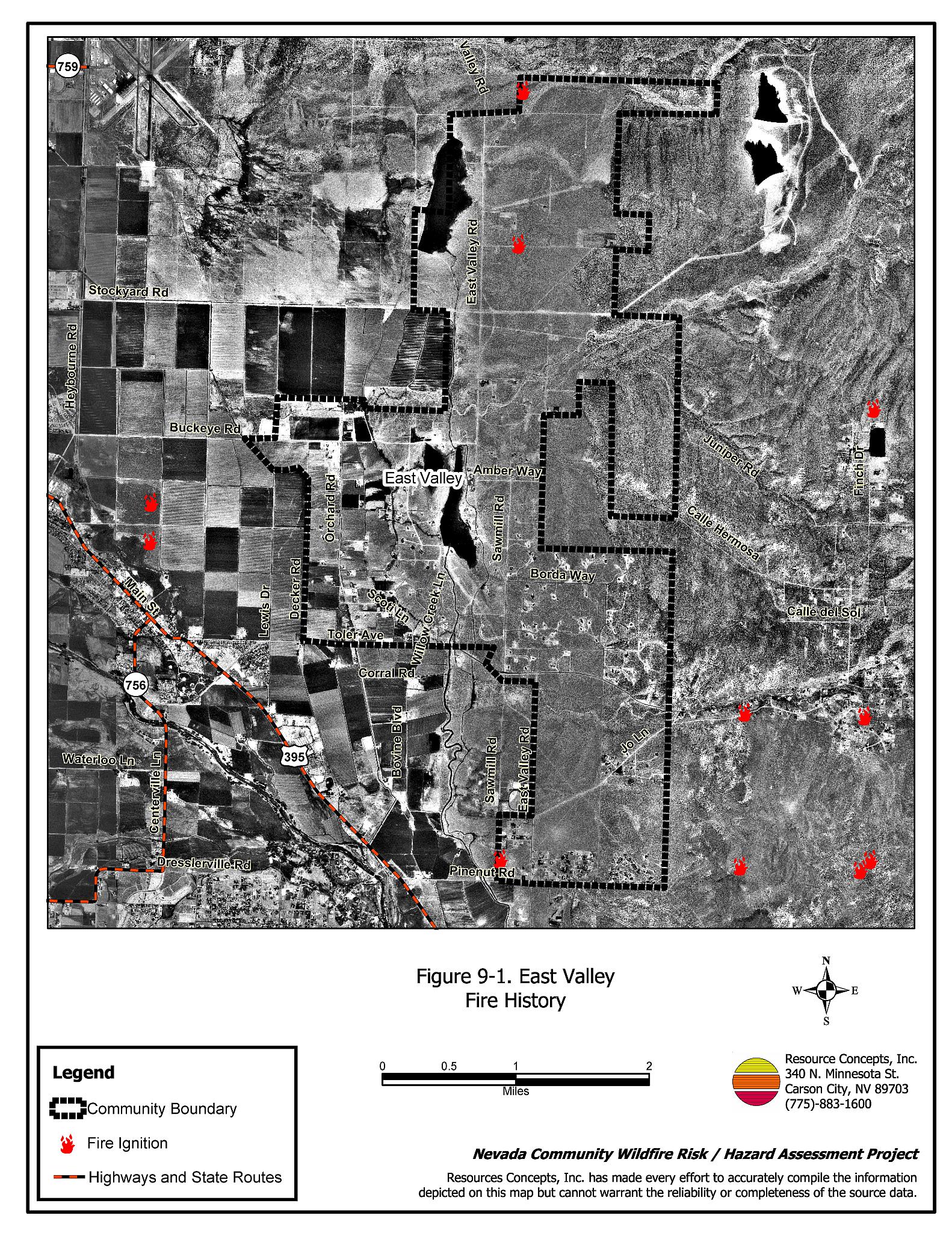
The East Valley interface area is characterized as an intermix wildland-urban interface condition. Structures are scattered throughout the wildland area with no clear line of demarcation between wildland fuels and residences in the community. The majority of lots assessed were on parcels between one and ten acres (see Figure 9-1).
- Roads: Toler Avenue, East Valley Road, and Fish Springs Road are the primary roads providing access between the East Valley community and other communities in Douglas County. The roads are paved and are between twenty and 24 feet in width and provide adequate access for fire suppression vehicles. Most of the secondary community roads have adequate turn around space for fire suppression equipment, and the majority of community roads have less than a five percent gradient.
- Signage: Street names were adequately identified with reflective lettering. Residential addresses were visible on most of the homes assessed. Clear and visible residential addresses are important to aid firefighting personnel in locating homes during low visibility conditions that occur during a wildland fire.
- Utilities: Both overhead and underground power lines are present within the community. Power line right-of-ways were properly maintained, which minimizes the possibility of power lines sparking during windstorms and starting fires in nearby vegetation.
9.1.2 Construction Materials
Approximately eight percent of the homes assessed have wood shake roofing materials. The remainder of the homes observed were built with fire resistant siding materials and non-combustible roofing materials such as metal, tile, or asphalt composite materials. About ten percent of the homes observed have unenclosed balconies, porches, decks, or other architectural features that create drafts and provide areas where sparks and firebrands can be trapped, smolder, ignite, and rapidly spread fire to the home.
9.1.3 Defensible Space
A majority of the homes in the interface had landscaping that would meet the minimum defensible space requirement to help protect the home from damage or loss during a wildfire.
9.1.4 Suppression Capabilities
Wildfire Protection Resources
East Valley is provided wildland and structure fire protection by the Fish Springs Volunteer Fire Department (Station 9) and the Gardnerville Volunteer Fire Department (Station 2) of the East Fork Fire and Paramedic Districts. See Tables 4-2 and 4-3 for more information on the typical fire suppression response for first-alarm wildland-urban interface fires in Douglas County. Appendix E lists the type and number of fire suppression vehicles located at each EFFPD career staffed and VFD station.
Water Sources and Infrastructure
Water availability for fire suppression in East Valley includes two 50,000-gallon tanks equipped with a gravity fed hydrant. There is also a 240,000 gallon static fill tank located on Jo Lane that can be used as a drafting source (Blackbull Wildfire Services 2004a). There is no emergency generator for the pumps on the wells that fill the tanks. There are no hydrants available for structure protection in the community. The Carson River and various reservoirs throughout the community may be used for helicopter dip sites.
9.1.5 Factors Affecting Fire Behavior
Vegetation, dead and down fuels, and topographic features contribute to the potential fire hazard around wildland-urban interface communities. The terrain around East Valley is generally flat with slopes less than eight percent. The community is situated partially on west facing alluvial fans and floodplain.
The vegetative fuel density in the East Valley community was moderate, estimated at two to four tons per acre. Fuels in the community consisted primarily of sagebrush and horsebrush, with a cheatgrass, bottlebrush squirreltail, mustard, and Russian thistle understory. Typical shrub heights ranged between one and three feet. The fire behavior potential in East Valley was determined to be moderate due to the moderate fuel hazard combined with flat terrain and high wind exposure. Fire ignitions have occurred within the vicinity of the community from both human and lightning causes. The predominant wind direction is from the south/southwest especially in the late afternoon.
9.1.6 Fire Behavior Worst Case Scenario
The worst-case scenario for East Valley would likely occur in the event of a lightning or human-caused ignition within the community. With south or southwest winds exceeding 25 miles per hour, a fire could rapidly spread through tall brush fuels (one to three feet high) and quickly threaten structures. Extensive wood fencing throughout the community would contribute to the potential fuel load. The vinyl fencing investments throughout the community would be at risk of destruction should a wildfire occur in the community. The scenario would be worse if EFFPD resources were unavailable due to previous assignment to an emergency situation elsewhere.
9.1.7 Ignition Risk Assessment
East Valley has been rated with a moderate ignition risk. While there is an ignition history reported for the area (Figure 9-1), there is no significant wildfire history in the immediately adjacent area, possibly due to the low to moderate fuel hazards. Ditch burning is another human-caused ignition risk that occurs near the community.
9.2 Risk and Hazard Reduction Recommendations
The East Valley risk and hazard reduction recommendations address the primary concern regarding protection of existing and future development in the wildland-urban interface area. Other recommendations pertain to community coordination and public education efforts that could be undertaken to enhance fire safety in East Valley.
9.2.1 Defensible Space Treatments
Defensible space treatments are an essential first line of defense for residential structures. Significantly reducing or removing vegetation within a prescribed distance from structures (100 to 200 feet depending on slope and vegetation type) reduces fire intensity and improves firefighter and homeowner chances for successfully defending a structure against an oncoming wildfire.
Property Owner Recommendations
- Remove, reduce, and replace vegetation around homes according to the guidelines in Appendix D. This area should be kept:
- Lean: There are only small amounts of flammable vegetation,
- Clean: There is no accumulation of dead vegetation or other flammable debris,
- Green: Existing plants are healthy and green during the fire season.
- Remove debris and flammable materials from within the defensible space area.
- Cheatgrass or other annual grasses that have become dominant within the defensible space zone should be mowed or treated with an application of pre-emergent herbicide prior to seed set. Treatments may need to be repeated the following year to ensure that the seed bank of unwanted grasses has been depleted. Refer to Appendix D for approved seed mixes and planting guidelines that can be used in conjunction with removal of this annual grass.
- Store firewood a minimum distance of thirty feet from structures.
- Maintain areas under wood decks and porches free of weeds and other flammable debris. Enclose these areas wherever possible.
- Remove shrubs within 25 feet and cheatgrass within ten feet of wood and vinyl fences throughout the community. Either maintain this area free of weeds and annual vegetation or plant fire resistant grass and forb species referenced in Appendix D.
- Install spark-arresting screens on chimneys.
- Annually remove vegetation and debris along irrigation ditches to reduce the fuel load.
- Immediately dispose of cleared vegetation when implementing defensible space treatments. The material dries quickly and poses a fire hazard if left on site.
- Maintain this defensible space as needed to keep the space lean, clean, and green.
9.2.2 Fuel Reduction Treatments
Fuel reduction treatments are applied on a larger scale than defensible space treatments. By permanently changing the fuel structure over large blocks of land to one of a lower volume or reduced flammability (a fuel reduction treatment), the expected result in the event of a catastrophic wildfire would be one of reduced capacity for uncontrolled spread through the treatment area.
Utility Company Recommendation
- Reduce vegetation a minimum distance of fifteen feet from all utility poles to reduce the risk of loss during a fire and reduce the chance of sparks igniting nearby vegetation.
Douglas County Roads Department Recommendation
- Remove shrubs and weeds for a distance of 25 feet along Buckeye Road, East Valley Road, Amber Way, Borda Way, Toler Avenue, Fish Springs Road, and Jo Lane. Reseed if necessary to control cheatgrass and other invasive weeds. Recommended seed mixtures and planting guidelines are included in Appendix D.
9.2.3 Community Coordination
Many of the most effective activities aimed at reducing the threat of wildfire for the East Valley community require that individual property owners coordinate with each other and with local fire authorities. Address signage and defensible space, for example, are more effective in small communities when applied uniformly throughout entire neighborhoods. Public education and awareness, neighbors helping neighbors, and proactive individuals setting examples for others to follow are just a few of the approaches that will be necessary to meet the fire safe goals in the community. Disposal of biomass generated from defensible space and fuel reduction treatments can sometimes be most efficiently handled through community programs.
Property Owner Recommendations
- Assure residential addresses are visible from the road. Address characters should be at least four inches high and reflective. Improving visibility of addresses will make it easier for those unfamiliar with the area to navigate an area during a wildland fire.
- Form a local chapter of the Nevada Fire Safe Council. The Nevada Fire Safe Council proposes to work on solutions that reduce the risk of loss of lives and property from wildfires in Nevada’s communities. Through establishment of a local Chapter, communities become part of a large information-sharing network that receives notifications of programs and funding opportunities for fire mitigation projects such as those listed in this report. The Nevada Fire Safe Council will accept and manage grants and contracts on the Chapter’s behalf through its non-profit status. The Nevada Fire Safe Council provides assistance and support to communities to complete fire safe plans, set priorities, educate and train community members, and promote success stories of its members. For more information on forming a chapter, contact:
Nevada Fire Safe Council
1187 Charles Drive
Reno, Nevada 89509
www.nvfsc.org
East Fork Fire and Paramedic Districts Recommendation
- Distribute copies of the publication “Living With Fire” to all property owners who live in wildland-urban interface areas in East Valley. This publication is free of charge. Copies can be requested from the University of Nevada Cooperative Extension.
9.3 Summary of Recommendations
| Involved Party | Recommended Treatment | Recommendation Description |
|---|---|---|
| Property Owners | Defensible Space | Remove, reduce, and replace vegetation around homes according to the defensible space guidelines in Appendix D. |
| Community Coordination | Assure addresses are visible from the road on all homes within the community. Form a local chapter of the Nevada Fire Safe Council. |
|
| Douglas County | Fuels Reduction | Remove shrubs and weeds for a distance of 25 feet along primary roads in the community. |
| Utility Company | Fuels Reduction | Reduce vegetation a minimum distance of fifteen feet from all utility poles to reduce the risk of loss during a fire and reduce the chance of sparks igniting nearby vegetation. |
| East Fork Fire and Paramedic Districts | Community Coordination | Distribute copies of the publication “Living With Fire” to all property owners. |
Table 9-2East Valley Wildfire Hazard Assessment Summary Sheet |
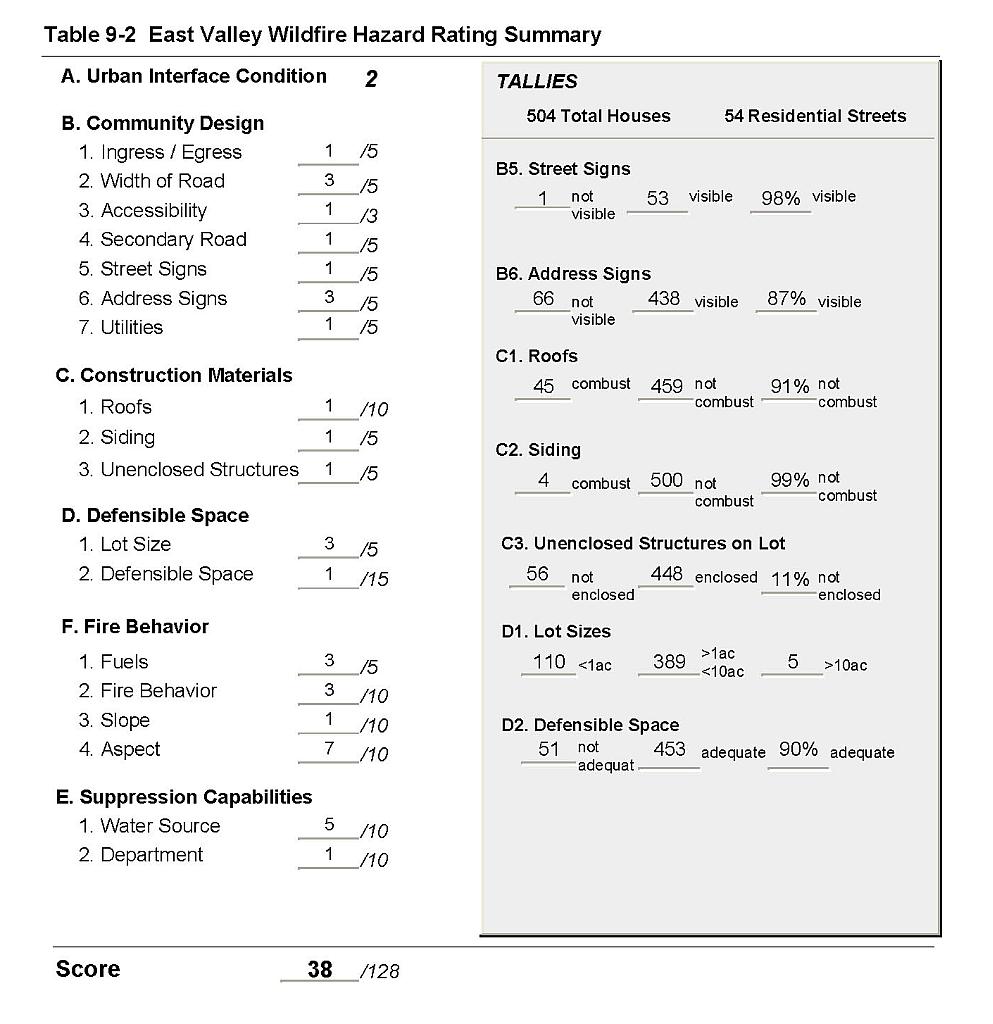 |
Figure 9-1East Valley Fire History |
 |