![]()
![]()
10.0 Fish Springs
10.1 Blackbull Wildfire Services Hazard and Risk Assessment
In 2004, Blackbull Wildfire Services completed an assessment entitled “Community Wildfire Threat Reduction and Project Implementation Plan for Fish Springs, September 2004,” on behalf of the Nevada Fire Safe Council. The pertinent information for this report is summarized from the Blackbull Fish Springs assessment.
Fish Springs is a community of approximately 700 residents located five miles east of Gardnerville, Nevada. The majority of the residences are located along the valley floor (4,900 feet elevation) and are surrounded by public land. The assessment resulted in classifying the Fish Springs community in the High Hazard category. The primary hazard factor for the Fish Springs area was the high fuel hazard vegetation.
10.1.1 Community Design
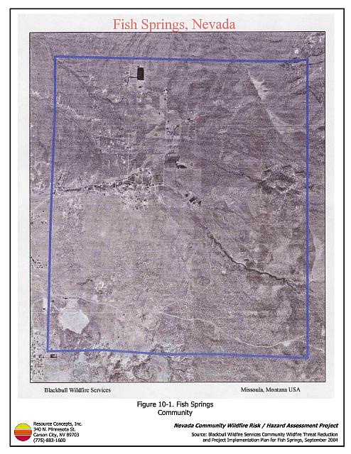
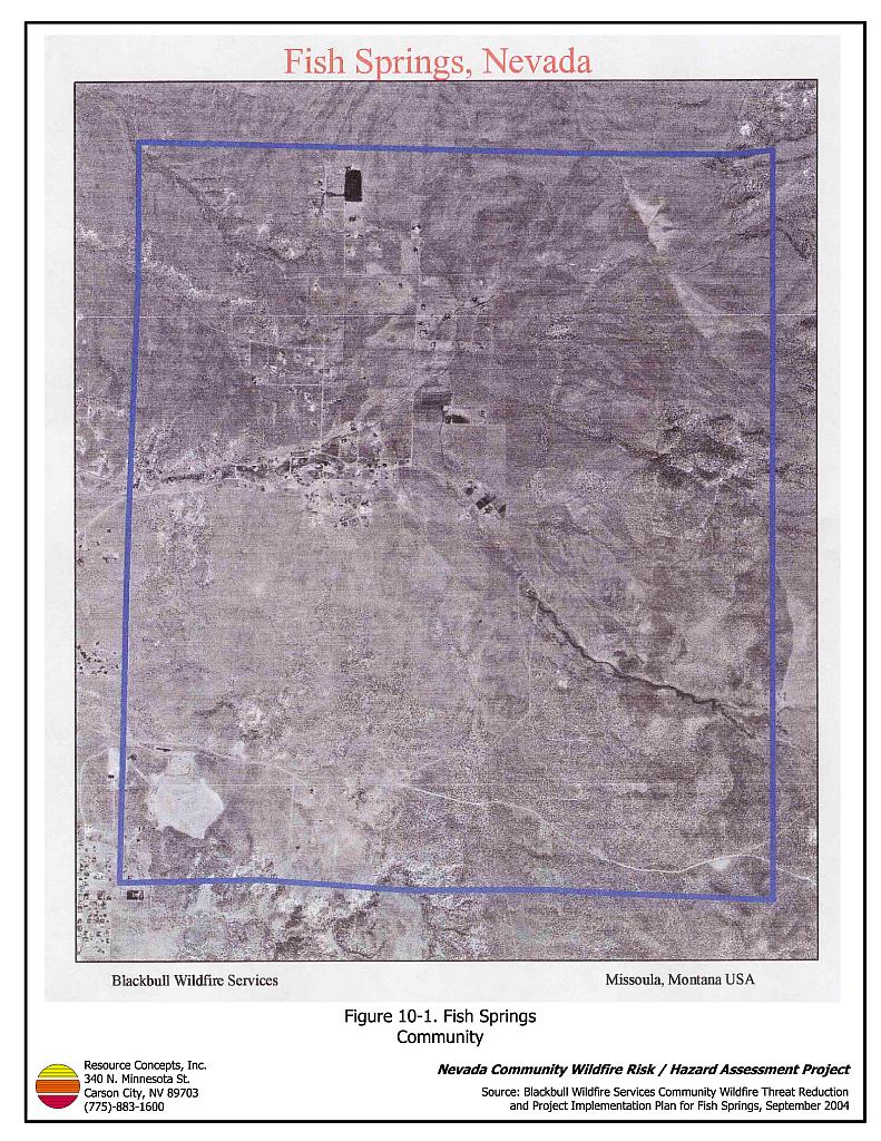
The Fish Springs interface area is characterized by an intermix wildland-urban interface condition. Structures are scattered throughout the wildland area with no clear line of demarcation between wildland fuels and residences in the community. (Figure 10-1).
- Roads: Fish Springs Road is the primary road connecting the Fish Springs community with other communities in Douglas County.
- Utilities: All utilities were noted to be above ground. Reducing vegetation underneath and adjacent to power lines minimizes the possibility of power lines producing sparks during windstorms and starting fires in nearby vegetation.
10.1.2 Defensible Space
A majority of homes in the community lacked proper defensible space or vegetation clearance. In Fish Springs the recommended minimum defensible space distance ranged between 100 and 200 feet depending upon slope.
10.1.3 Suppression Capabilities
Wildfire Protection Resources
The Fish Springs Volunteer Fire Department (Station 9) of the East Fork Fire and Paramedic Districts is responsible for wildfire and structure fire protection in the Fish Springs community. At the time of the assessment, the Fish Springs VFD listed twenty volunteers on its roster (East Fork Fire Protection District website). See Tables 4-2 and 4-3 for more information on the typical fire suppression response for first-alarm wildland-urban interface fires in Douglas County. Appendix E lists the type and number of fire suppression vehicles located at each EFFPD and Douglas County VFD station.
The BLM / Interagency wildland fire resources will also respond to all wildland fire reports within the Fish Springs community. The BLM stations a wildland fire engine at the Fish Springs Volunteer Fire Department to respond to threats to the adjacent public land. The response will be initiated by the Sierra Front Interagency Dispatch Center.
Water Sources and Infrastructure
No hydrants are available within the community; however, an 18,00-gallon tank is available as a drafting source at the VFD. There is also a 240,000 static fill tank located on Jo Lane in the East Valley community that can be used as a drafting source with less than a twenty-minute turn around time.
Community Preparedness
The Fish Springs community has shown interest in forming a local chapter of the Nevada Fire Safe Council; however, a chapter had not yet been formed at the time of the assessment. There is currently no evacuation plan for residents of the community, nor do the emergency and disaster plans provide information on safe zones within the community.
10.1.4 Factors Affecting Fire Behavior
Vegetation, dead and down fuels, and topographic features contribute to the potential fire hazard around wildland-urban interface communities. The terrain in the community is generally flat with a box canyon near Burro Court and slopes of all aspects surrounding the edges of the community. There is a significant history of large fires and fire ignitions near the community.
The vegetation in the Fish Springs community was generally classified as a high hazard fuel type, dominated primarily by pinyon pine, Utah juniper, and big sagebrush.
10.1.5 Previous Fire Hazard Reduction Projects
In 2004 the BLM Carson Field Office funded a Student Conservation Association Fire Education Corp Team that completed a home demonstration project in the Fish Springs community. The Team made the residential site "fire wise" by removing and thinning hazardous fuels within a distance of fifty feet of the residence. Other homeowners were provided with defensible space educational materials and evaluations of defensible space conditions.
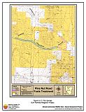
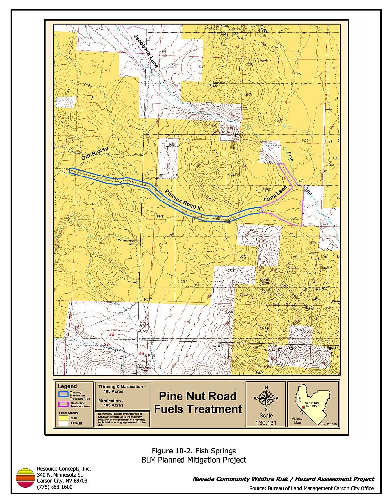
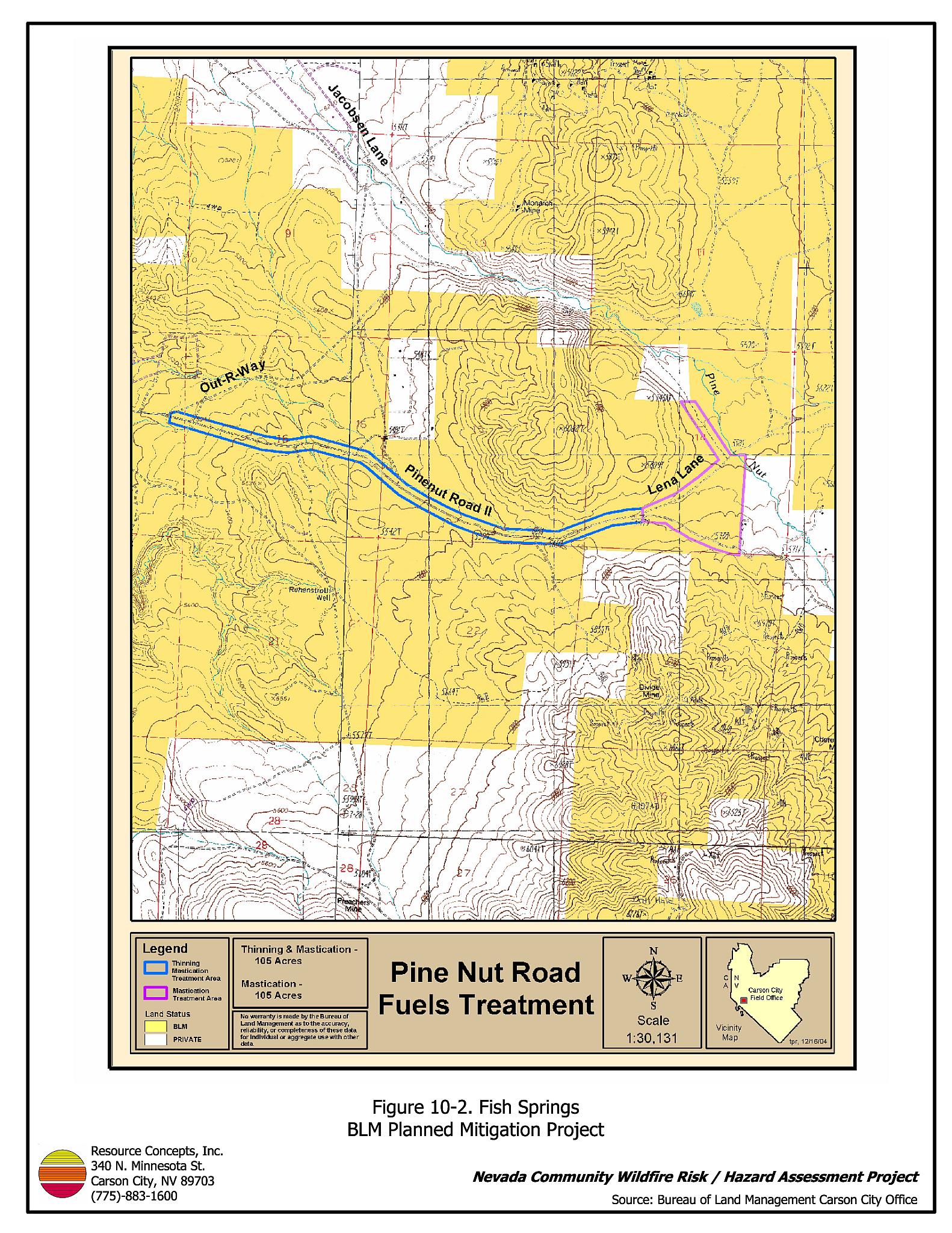
The Bureau of Land Management Carson City Field Office is implementing a fuel reduction treatment at the south end of the Fish Springs community along Pine Nut Road II from Out-R-Way to Lena Lane (Figure 10-2). The project area was first initiated by opening the area to public woodcutting between October 2004 and January 2005. Project specifications for the two treatment areas include reducing tree and shrub cover by approximately 90 percent using mechanical mastication. The mastication treatment is currently underway and will be completed in May 2005.
Additional fuel reduction treatments are scheduled to be completed in 2005 on private lands in the Bluebird Way-Wheaton Lane area of Fish Springs. A perimeter shaded fuelbreak and interior road treatments are planned. Trees will be thinned to approximately 40 trees per acres, brush removed, and limbs removed within four feet of the ground on remaining trees within the proposed treatment areas.
10.1.6 Fire Behavior and Worst Case Scenario
The worst-case scenario for the Fish Springs community would consist of several lightning or possibly human-caused ignitions starting west, southwest, or south of the southern end of the community, near Wheaton Lane. Fire ignitions could quickly threaten the community if they started in the afternoon of a windy, low humidity, day when helicopter or air tanker resources are already committed to other fires.
10.1.7 Ignition Risk Assessment
The risk assessment assigned Fish Springs a high ignition risk rating. A significant history of wildfire and fire ignitions exists in the public lands and private lands surrounding the community. High ignition rates are likely due to the high fuel loads in and around the community, the tendency for lightning storms during the summer, and the high number of people using the wildlands near Fish Springs.
10.2 Risk and Hazard Reduction Recommendations
The Fish Springs risk and hazard reduction recommendations focus on improving defensible space and promoting homeowner responsibilities. Other recommendations pertain to community coordination efforts that could be initiated to enhance the fire safe nature of the Fish Springs community. Recommendations are detailed below.
10.2.1 Defensible Space
In addition to the following recommendations developed by Blackbull (2004), the RCI Project Team strongly recommends adding recommendations that pertain to defensible space. Defensible space treatments are an essential first line of defense for residential structures. Significantly reducing or removing vegetation within a prescribed distance from structures (minimum of 100 feet to 200 feet depending upon slope) reduces fire intensity and improves firefighter and homeowner chances for successfully defending a structure against an oncoming wildfire.
Property Owner Recommendations
- Remove, reduce, and replace vegetation to create defensible space around homes according to the guidelines in Appendix D. This area should be kept:
- Lean: There are only small amounts of flammable vegetation,
- Clean: There is no accumulation of dead vegetation or other flammable debris,
- Green: Existing plants are healthy and green during the fire season.
- Remove debris and flammable materials from within the defensible space area.
- Store firewood a minimum distance of thirty feet from structures.
- Mow or remove brush for a distance of 25 feet along each side of wood or vinyl fences in the community.
- Cheatgrass or other annual grasses that have become dominant within the defensible space zone should be mowed or treated with an application of pre-emergent herbicide prior to seed set. Treatments may need to be repeated the following year to ensure that the seed bank of unwanted grasses has been depleted. Refer to Appendix D for recommended seed mixes and planting guidelines that can be used in conjunction with removal of this annual grass.
- Maintain areas under wood decks and porches free of weeds and other flammable debris. Enclose these areas wherever possible.
- Clear all vegetation and combustible materials around propane tanks for a minimum of ten feet.
- Remove or properly board up abandoned trailers and mobile homes to prevent sparks from entering and igniting the structures.
- Install spark-arresting devices on chimneys.
- Thin pinyon and juniper trees in the defensible space area such that tree canopies are spaced a minimum distance of thirty feet from any other trees, shrubs, or residential structures. Limb branches of remaining pinyon and juniper trees within the defensible space area a minimum of four feet from the ground, or no more than one-third of the tree height. Reduce the needle and cone duff from under the remaining trees to a depth no greater than one-inch.
- Irrigate all trees and shrubs in close proximity to structures to increase their fire resiliency, especially during drought conditions.
- Immediately dispose of cleared vegetation when implementing defensible space treatments. This material dries quickly and poses a fire hazard if left on site.
- Maintain this defensible space as needed to keep the space lean, clean, and green.
10.2.2 Fire Suppression Capabilities
East Fork Fire and Paramedic Districts Recommendations
- Inventory the known water sources and place signs identifying them as a fire suppression apparatus drafting source. Install additional 8,000 to 10,000-gallon dry hydrants in various locations throughout the community.
- Develop a pre-attack plan for the Fish Springs community. The plan should include information regarding the location of water sources, helibases, evacuation plans, resident safety zones, locations of recent fuel reduction projects, and other fire protection facility information.
10.2.3 Fuel Reduction Treatments
Bureau of Land Management Recommendation
- Complete construction of the planned fuel reduction treatments along Out-R-Way and Lena Lane (Figure 10-2).
Nevada Fire Safe Council and Bureau of Land Management Recommendation
- Complete construction of the planned fuel reduction treatments in the Bluebird Way-Wheaton Lane area of the Fish Springs community.
10.2.4 Community Coordination
Property Owner Recommendation
- Form a local chapter of the Nevada Fire Safe Council. The Nevada Fire Safe Council proposes to work on solutions that reduce the risk of loss of lives and property from wildfires in Nevada’s communities. Through establishment of a local Chapter, communities become part of a large information-sharing network that receives notifications of programs and funding opportunities for fire mitigation projects such as those listed in this report. The Nevada Fire Safe Council will accept and manage grants and contracts on the Chapter’s behalf through its non-profit status. The Nevada Fire Safe Council provides assistance and support to communities to complete fire safe plans, set priorities, educate and train community members, and promote success stories of its members. For more information on forming a chapter, contact:
Nevada Fire Safe Council
1187 Charles Drive
Reno, Nevada 89509
www.nvfsc.org
East Fork Fire and Paramedic Districts Recommendations
- Develop a community fire notification and evacuation plan for the Fish Springs Community, including notification plans for homeowners and recreation users. Install permanent signs clearly showing ingress and egress routes within the community in areas of high use by mountain bikers and ATV users.
- Prepare a community-wide fire safe plan including information on individual home preparedness, fire awareness, and fire prevention education for homeowners and recreation users.
10.3 Summary of Recommendations
| Involved Party | Recommended Treatment | Recommendation Description |
|---|---|---|
| Property Owners | Defensible Space | Remove, reduce, and replace vegetation around homes to create a minimum of seventy feet of defensible space. |
| Community Coordination | Form a local chapter of the Nevada Fire Safe Council. | |
| BLM | Fuels Reduction Treatments | Complete construction of the planned fuel reduction treatments along Out-R-Way and Lena Lane. |
| Nevada Fire Safe Council BLM |
Fuels Reduction Treatments | Complete construction of the planned fuel reduction treatments in the Bluebird Way-Wheaton Lane area. |
| East Fork Fire and Paramedic Districts | Fire Suppression Capability | Inventory known water sources and install additional 8,000 to 10,000-gallon dry hydrants in various locations throughout the community. Develop a pre-attack plan for the Fish Springs community. |
| Community Coordination | Develop a community fire notification and evacuation plan and install permanent signs showing clear ingress and egress routes within the community. Prepare a community-wide fire safe plan for the community. |
Figure 10-1Fish Springs Community |
 |
Figure 10-2Fish Springs BLM Planned Mitigation Project |
 |