![]()
![]()
8.0 Dresslerville Colony
8.1 SWCA Hazard and Risk Assessment
In 2002, SWCA Environmental Consultants completed an assessment entitled “Wildfire Hazard Assessment and Mitigation Plan for the Dresslerville Colony, Washoe Tribe of Nevada and California,” on behalf of the Bureau of Indian Affairs, Western Nevada Agency. The pertinent information for this report is summarized from the SWCA Dresslerville assessment.
The 795-acre Dresslerville Colony is located along US Highway 395, approximately one mile south of Gardnerville and is bordered by the Gardnerville Ranchos community to the west. The Colony is situated on the west side of the highway and is dissected by the east fork of the Carson River. This assessment included 144 single-family residences in the Dresslerville Colony. The assessment resulted in classifying the Dresslerville Colony in the Moderate Hazard category (adapted from the Wildfire Hazard Assessment and Mitigation Plan for the Dresslerville Colony, Washoe Tribe of Nevada and California, January 2003). The primary hazard factors for the Dresslerville Colony were limited address signage on residences and residential streets in addition to limited defensible space implementation throughout the community.
8.1.1 Community Design
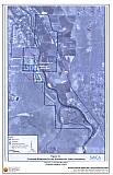
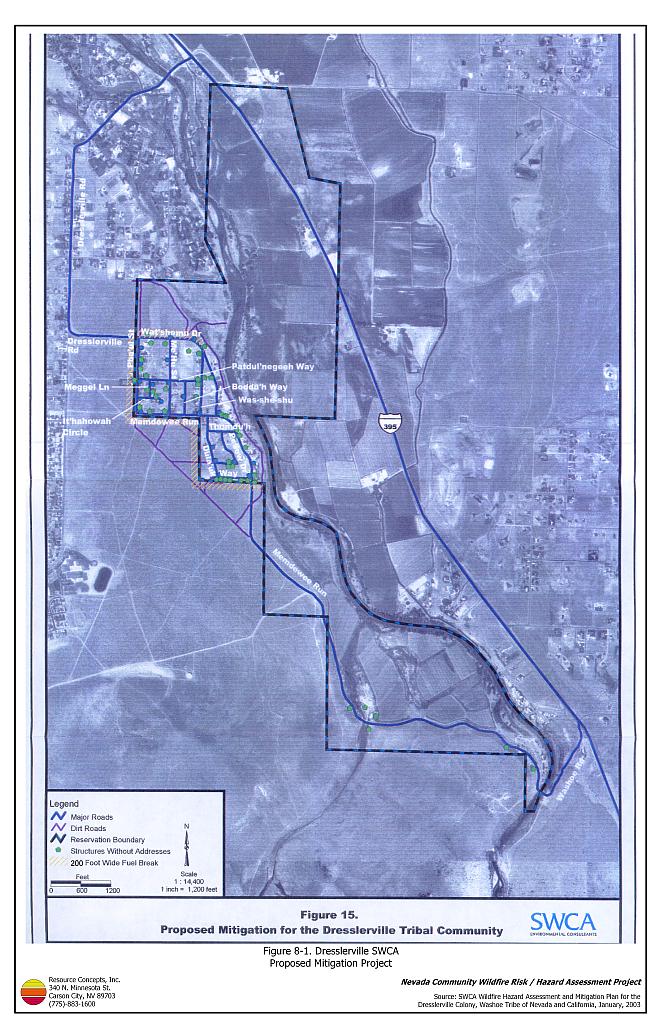
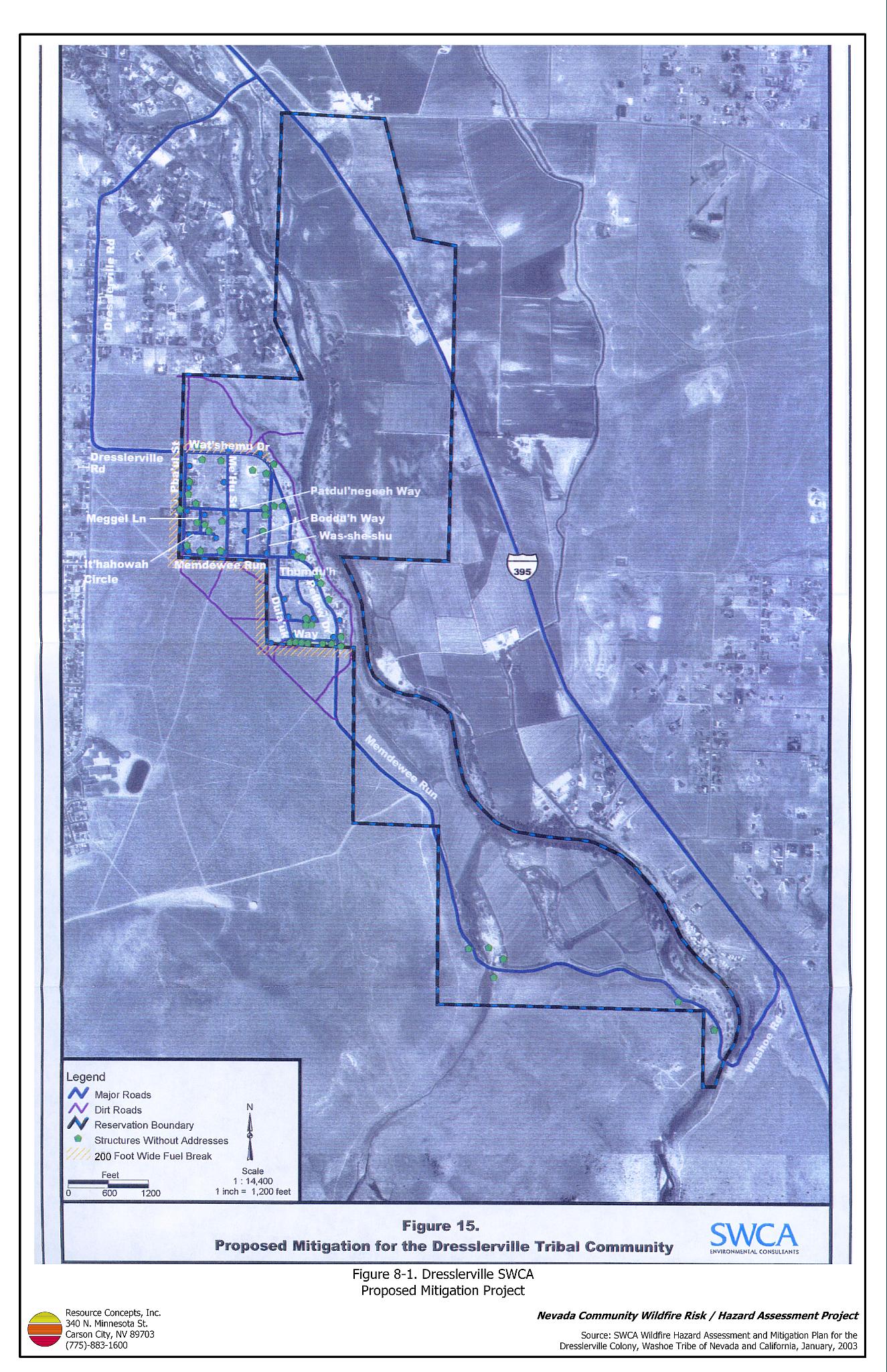
The Dresslerville Colony demonstrated the characteristics of the classic wildland-urban interface condition. In many areas, subdivisions border wildland fuels with a clear line of demarcation between the fuels and the residences. A majority of the homes assessed were on parcels of one acre or less. As such, most structures are spaced close together (see Figure 8-1).
- Roads: Dresslerville (Wat’sheamu) and Washoe (Memdewee) Roads are the primary roads connecting the Dresslerville Colony with other communities in Douglas County.
- Utilities: Power lines in the Dresslerville Colony were noted to be above ground. Reducing vegetation underneath and adjacent to power lines minimizes the possibility of power lines producing sparks during windstorms and starting fires in nearby vegetation.
8.1.2 Construction Materials
Residences in the community were built with class C rated wood siding, which burns in less than twenty minutes. Most homes were updated with Class B roofing material in 1995. None of the homes observed had unenclosed balconies, porches, decks, or other architectural features that create drafts and provide areas where sparks and firebrands can be trapped, smolder, ignite, and rapidly spread fire to the home.
8.1.3 Defensible Space
Approximately 86 percent of the homes assessed had landscaping that meets the minimum defensible space requirement to help protect the home from damage or loss during a wildfire. In the Dresslerville Colony the recommended minimum defensible space distance ranged between thirty and 100 feet depending upon vegetation type.
8.1.4 Suppression Capabilities
Wildfire Protection Resources
The Gardnerville Ranchos Volunteer Fire Department, East Fork Fire and Paramedic Districts Station 7 (combination career-volunteer), and the Bureau of Land Management Carson Field Office provide structure and wildland fire protection to the Dresslerville Colony. Station 7 responded to over 500 calls in 2003. The Gardnerville Ranchos VFD reported thirty volunteers at the time of the assessment (East Fork Fire Protection District website). See Tables 4-2 and 4-3 for more information on the typical fire suppression response for first-alarm wildland-urban interface fires in Douglas County. Appendix E lists the type and number of fire suppression vehicles located at each EFFPD career staffed and VFD station.
Water Sources and Infrastructure
Hydrants are available within 500 feet of residences in the northern section of the Colony, where most of the homes are located. The Carson River is a possible helicopter dip spot.
8.1.5 Factors Affecting Fire Behavior
Vegetation, dead and down fuels, and topographic features contribute to the potential fire hazard around wildland-urban interface communities. The terrain throughout the Colony is flat as it is situated on the Carson River floodplain. The predominant winds are from the west. There is a history of wildfire near the community as evidenced by a 1984 fire that burned within one mile southeast of structures in the Colony.
Three predominant vegetation types were identified in the community including sagebrush/annual grass scrub, native riparian, and irrigated agriculture. The dominant shrub species in the sagebrush/annual grass type are sagebrush, rabbitbrush, and bitterbrush with a grass understory of cheatgrass, Indian ricegrass, needlegrass, and Sandberg bluegrass. The shrubs generally ranged between one and three feet in height and the fuel hazard in these areas was considered moderate.
The predominant species in the riparian vegetation type include willow, cottonwood, and sedges. The fuel type was considered a low fuel hazard. The irrigated agricultural lands were either alfalfa or pasture grasses. Due to the annual (or more frequent) harvest of the vegetation and the irrigated, fire-resistant, qualities of the vegetation these lands were rated as a low fuel hazard.
8.1.6 Previous Fire Hazard Reduction Projects
In 2004, the Washoe Tribe Environmental Protection Department constructed a twenty to thirty-foot wide fuelbreak south of the main cluster of homes in the Dresslerville community. The fuelbreak was constructed by mowing sagebrush to a six-inch height along the Washoe Tribe property boundary.
8.1.7 Fire Behavior and Worst Case Scenario
The RCI Project Team described a worst-case scenario for the Dresslerville Colony as an event that would likely occur with a fire starting south of the main cluster of residences on a high hazard day. With strong winds, 25 mph or greater from the south or southwest, a fire could quickly burn through the moderate hazard sagebrush vegetation and threaten homes. The scenario would be worse if East Fork Fire and Paramedic Districts resources were unavailable due to assignment to an emergency situation elsewhere.
8.1.8 Ignition Risk Assessment
Dresslerville has a low potential for ignition based on the number of ignitions and fire history for the area. Ditch burning and large equipment have been the primary human-caused ignition risks near the community.
8.2 SWCA Risk and Hazard Reduction Recommendations
Risk and hazard reduction recommendations developed by SWCA for the Dresslerville community focus on improving defensible space and promoting homeowner responsibilities. Other recommendations pertain to community coordination efforts that could be initiated to enhance the fire safe nature of the Dresslerville Colony. The RCI Project Team concurred with these recommendations.
8.2.1 Defensible Space
Property Owner Recommendation
- Implement defensible space to a minimum distance of 70 feet for 16 structures in the community.
8.2.2 Community Coordination
Washoe Tribe and Property Owner Recommendation
- Clearly identify all streets with signs that have reflective letters four inches in height. Clearly mark all residences with the appropriate address.
Washoe Tribe Recommendations
- Widen Dula’Uk Way to 24 feet and resurface with an aggregate or pave.
- Improve a 0.25 length of road from Pellow Drive to Memdewee Run.
8.2.3 Fuel Reduction Treatments
Bureau of Indian Affairs, Washoe Tribe, and Property Owner Recommendations
- Construct and maintain a 200-foot wide and 2.5 mile long fuelbreak [greenstrip] around the western, southern, and northern perimeters of the community. The specifications include removing all vegetation down to bare soil and seeding with perennial native grasses. Recommended seed mixtures and planting guidelines are provided in Appendix D.
8.3 RCI Risk and Hazard Reduction Recommendations
8.3.1 Fuel Reduction Treatments
Utility Company Recommendation
- Remove shrubs within fifteen feet of power poles and trim tree limbs within fifteen feet of power lines throughout the Dresslerville Colony.
Washoe Tribe Recommendation
- Remove or mow vegetation within ten feet of fire hydrants throughout the Dresslerville Colony.
8.3.2 Community Coordination
Washoe Tribe Recommendation
- Form a local chapter of the Nevada Fire Safe Council. The Nevada Fire Safe Council proposes to work on solutions that reduce the risk of loss of lives and property from wildfires in Nevada’s communities. Through establishment of a local Chapter, communities become part of a large information-sharing network that receives notifications of programs and funding opportunities for fire mitigation projects such as those listed in this report. The Nevada Fire Safe Council will accept and manage grants and contracts on the Chapter’s behalf through its non-profit status. The Nevada Fire Safe Council provides assistance and support to communities to complete fire safe plans, set priorities, educate and train community members, and promote success stories of its members. For more information on forming a chapter, contact:
Nevada Fire Safe Council
1187 Charles Drive
Reno, Nevada 89509
www.nvfsc.org
East Fork Fire and Paramedic Districts and Washoe Tribe Recommendations
- Distribute copies of the publication “Living With Fire” to all homeowners in the Dresslerville Colony. This publication is free of charge. Copies can be requested from the University of Nevada Cooperative Extension.
8.4 Summary of Recommendations
| Involved Party | Recommended Treatment | Recommendation Description |
|---|---|---|
| Property Owners | Defensible Space | Remove, reduce, and replace vegetation around homes to create a minimum of seventy feet of defensible space. |
| Community Coordination | Clearly identify all streets with signs that have reflective letters four inches in height. Clearly mark all residences with the appropriate address. | |
| Fuels Reduction | Cooperate with the Washoe Tribe and BIA to construct and maintain a 200-foot wide and 2.5 mile long fuelbreak. | |
| Washoe Tribe | Community Coordination | Clearly identify all streets with signs having letters four inches in height and reflective. Clearly mark all residences with the appropriate address.Ā Widen Dula’Uk Way to 24 feet and resurface with an aggregate or pave. Improve a 0.25 length of road from Pellow Drive to Memdewee Run. |
| Fuels Reduction | Construct and maintain a 200-foot wide and 2.5 mile long fuelbreak around the western, southern, and northern perimeters of the community. | |
| Bureau of Indian Affairs | Fuels Reduction | Construct and maintain a 200-foot wide and 2.5 mile long fuelbreak around the western, southern, and northern perimeters of the community. |
| Involved Party | Recommended Treatment | Recommendation Description |
|---|---|---|
| Washoe Tribe | Fuels Reduction | Remove or mow vegetation within ten feet of fire hydrants throughout the Dresslerville Colony. |
| Community Coordination | Form a local chapter of the Nevada Fire Safe Council. Cooperate with EFFPD to distribute copies of the publication “Living With Fire” to all homeowners. |
|
| Utility Company | Fuels Reduction | Remove shrubs within fifteen feet of power poles and trim tree limbs within fifteen feet of power lines throughout the Dresslerville Colony. |
| East Fork Fire and Paramedic Districts | Community Coordination | Distribute copies of the publication “Living With Fire” to all homeowners. |
Figure 8-1Dresslerville SWCA Proposed Mitigation Project |
 |