![]()
![]()
9.0 Virginia Highlands
9.1 Risk and Hazard Assessment
Wildfire risks and hazards to the Virginia Highlands community were assessed in 2002, with results and recommendations documented in Community Wildfire Risk Assessment and Fuel Reduction Plan for the Virginia Highlands Community. Resource Concepts, Inc. prepared this report for the Fire Safe Highlands and the University of Nevada, Reno - Cooperative Extension. For a complete treatment of the community, please refer to the original report (available online at http://www.rci-nv.com/reports/highlands). The following section is a brief review adopted from the 2002 report and includes information on the progress made in fuels reduction and other fire safe activities since the first report was issued.
Virginia Highlands is situated between approximately 5,800 feet at the Highlands Fire Station #2 to almost 7,000 feet at Geiger Summit on Highway 341 (Geiger Grade). Except for Fivemile Flat and the large flat near the Fire Station, the area is hilly with steep forested slopes. Minor ridges run in a southwest to northeast direction. Aspects are generally northwest and southeast. Using the assessment results from the 2002 report, a rating category of Extreme Hazard can be inferred, principally due to the combination of steep slopes, dense, flammable vegetation, very little defensible space, narrow roads, and limited access.
9.1.1 Community Design
The urban interface condition surrounding Virginia Highlands is intermixed. The Community consists of 1,169 one-acre lots clustered in the interior of the subdivision, with ten-acre parcels concentrically located around the one-acre core and forty acre parcels in the outermost extents of the subdivision. Therefore, structures and wildland fuels are not separated by clear lines of demarcation.
- Roads: Access to the area is gained from Highway 341. Cartwright Road is the main entry road to the north in the area of Fivemile Flat. Lousetown Road enters the development just north of Virginia City, also from Highway 341. These two main arteries into the subdivision are paved and intersect near Storey County Fire Station #2 in the Highlands. Residential roads are typically twenty feet wide with good drainage from a minimal road base. Base materials appear to be a mix of gravel and native soil.
Access across the project area is difficult in many places. The road network is generally winding and steep; many roads dead-end at driveways. Navigation from one artery to another on residential streets involves numerous turns. Many roads are constructed straight up the slopes, making them difficult to drive. Some roads are impassable to emergency equipment, especially under wet or icy conditions. - Signage: Most road signs were small, made of wood, and non-reflective, making them difficult for firefighters to read in many places. During a wildland fire, these signs may be destroyed making access to specific structures impossible for firefighters, especially those brought in from cooperating agencies that are not familiar with the neighborhoods. Small and uniform reflective street address signs have been installed where driveways meet the main road at many residences, a significant aid to rescue vehicles in locating specific homes.
- Utilities: All of the power utilities are above ground. Large propane tanks are located throughout the area, in many cases close to structures without adequate clearance from brush and trees.
9.1.2 Construction Materials
Homes within the Highlands Community have been built with a variety of roofing materials and exterior wall siding products. While the roofing materials on most residences were made of composite or other fire-resistant materials, some homes with highly flammable shake shingle roofs were observed. Most of the exterior walls observed during neighborhood reconnaissance were composed of wood products.
9.1.3 Defensible Space
The fuel hazard in the Virginia Highlands interface area ranges from moderate to extreme. Fuels consist of sagebrush with inclusions of bitterbrush, rabbitbrush, desert peach, pinyon pine, and juniper trees. The terrain is steep. At the time of the evaluation, the vast majority of the homes did not have landscaping that would meet the minimum requirement for defensible space to protect the home from damage or loss during a wildfire; however, activities focused on clearing defensible space have been initiated.
9.1.4 Suppression Capabilities
Wildfire Protection Resources
Storey County Fire Station #2 is located in the Virginia Highlands and, at the time of inquiry, this station reported housing three permanent firefighters, thirteen volunteers for the Storey County Fire Department, and the fire suppression equipment listed in Table 4-2 (G. Hames, pers. comm.). The Nevada Division of Forestry assigns a Type III engine and five seasonal firefighters to this station during the fire season. Resource availability and mutual aid agreements with Storey County Fire Protection District are described in Section 4.1.1.
Water Sources and Infrastructure
Virginia Highlands has the following water resources:
- Fifteen underground water storage tanks that total 247,000 gallons that are used as drafting tanks for filling water tenders.
- Fire hydrants are available in Virginia City, which is more than 45 minutes away, roundtrip .The fire main flow is 3,000 gpm per hydrant in Virginia City.
9.1.5 Factors Affecting Fire Behavior
Slopes range from zero to eighty percent with an average slope of about seventeen percent. Minor ridges run in a southwest to northeast direction. Aspects are generally northwest and southeast. The terrain has many topographic features conducive to extreme fire behavior, particularly canyons with steep slopes and saddles.
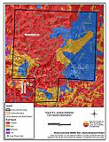
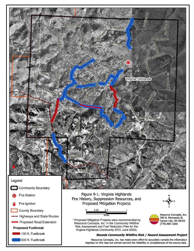
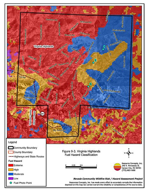
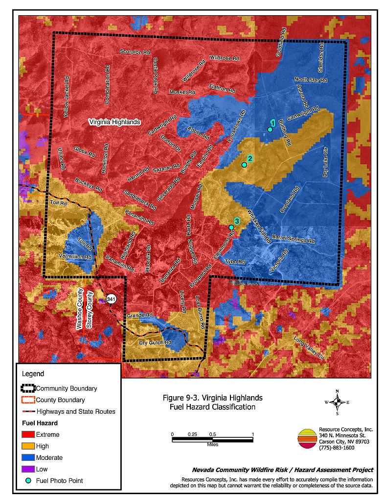
Numerous single-tree lightning strike fires occur during the summer in the Highlands area. These ignitions are usually extinguished before burning beyond the tree of origin. Historically, large fires in the general area have started to the west and to the north of the Virginia Highlands. A map of the fuel hazard condition for Virginia Highlands is shown in Figure 9-3. Photographs of fuel conditions in the Virginia Highlands interface area are included in Figure 9-4.
9.1.6 Fire Behavior Worst-case Scenario
An example of a worst-case wildfire scenario in the Highlands is a fire that starts southwest of the community near Highway 341 and Cartwright Road in mid-afternoon. Winds in excess of 35 mph from the southwest could move the fire in a northeast direction toward areas with extreme fuel loads and very limited road access.
The dense woodlands and steep topography in this area almost assure that the worst-case scenario wildfire will be carried through the canopy of the pinyon trees in a stand-destroying crown fire. A crown fire is the most perilous of all fire conditions and is usually catastrophic in nature since the danger to firefighters is generally too great to deploy ground crews. In the absence of a well-executed and aggressive fuels management plan before a fire occurs, virtually all of the vegetation, homes, and people in the path of a crown fire are at risk of destruction, injury and loss of life. In addition to limited possibilities for structure protection, there is a high possibility of loss of life in the worst-case wildfire scenario of a wind-driven crown fire.
9.1.7 Ignition Risk Assessment
The Virginia Highlands have been categorized with a high ignition risk rating. There is a history of lightning strikes in the area, as shown in Figure 9-1. Human caused ignitions can come from nearby highways and county roads by burning material thrown out of vehicle windows or ignited during auto accidents, recreational use by off-road vehicles, debris burning in piles or burn barrels, and firearm use on adjacent undeveloped lands.
9.2 Risk and Hazard Reduction Recommendations and Responsibilities
Resource Concepts, Inc provided the treatments and recommendations listed below in the June 2002 report. In that report, the Virginia Highlands were separated into four Fire Risk Zones; recommendations are provided for each risk zone. All recommendations are a priority.
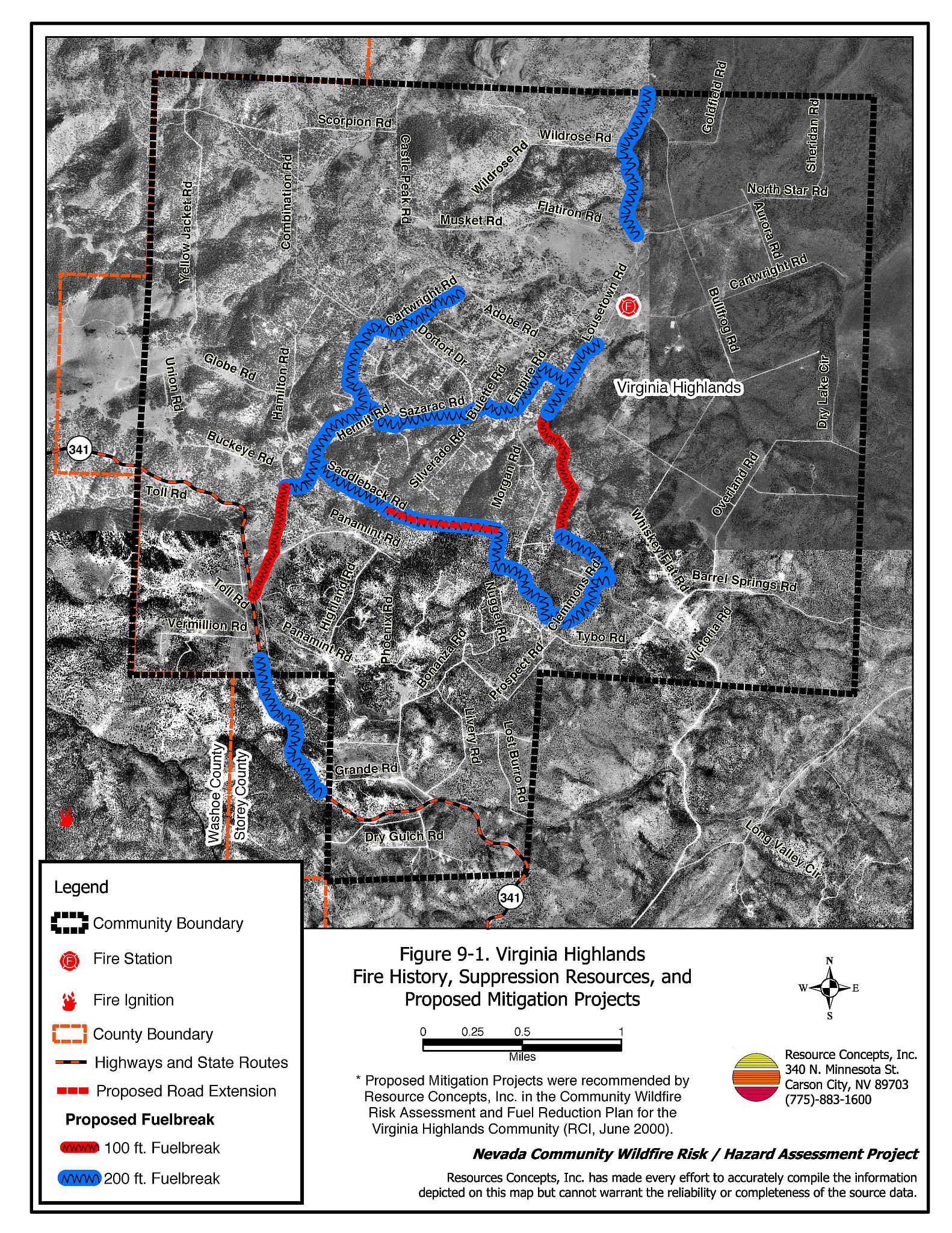
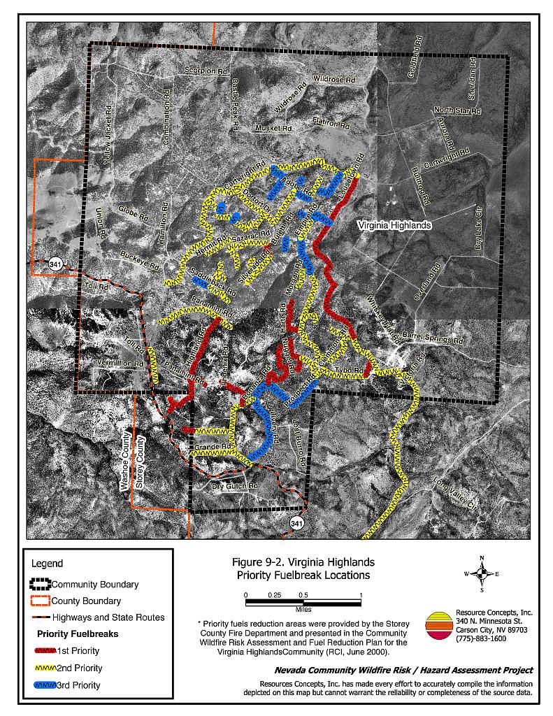
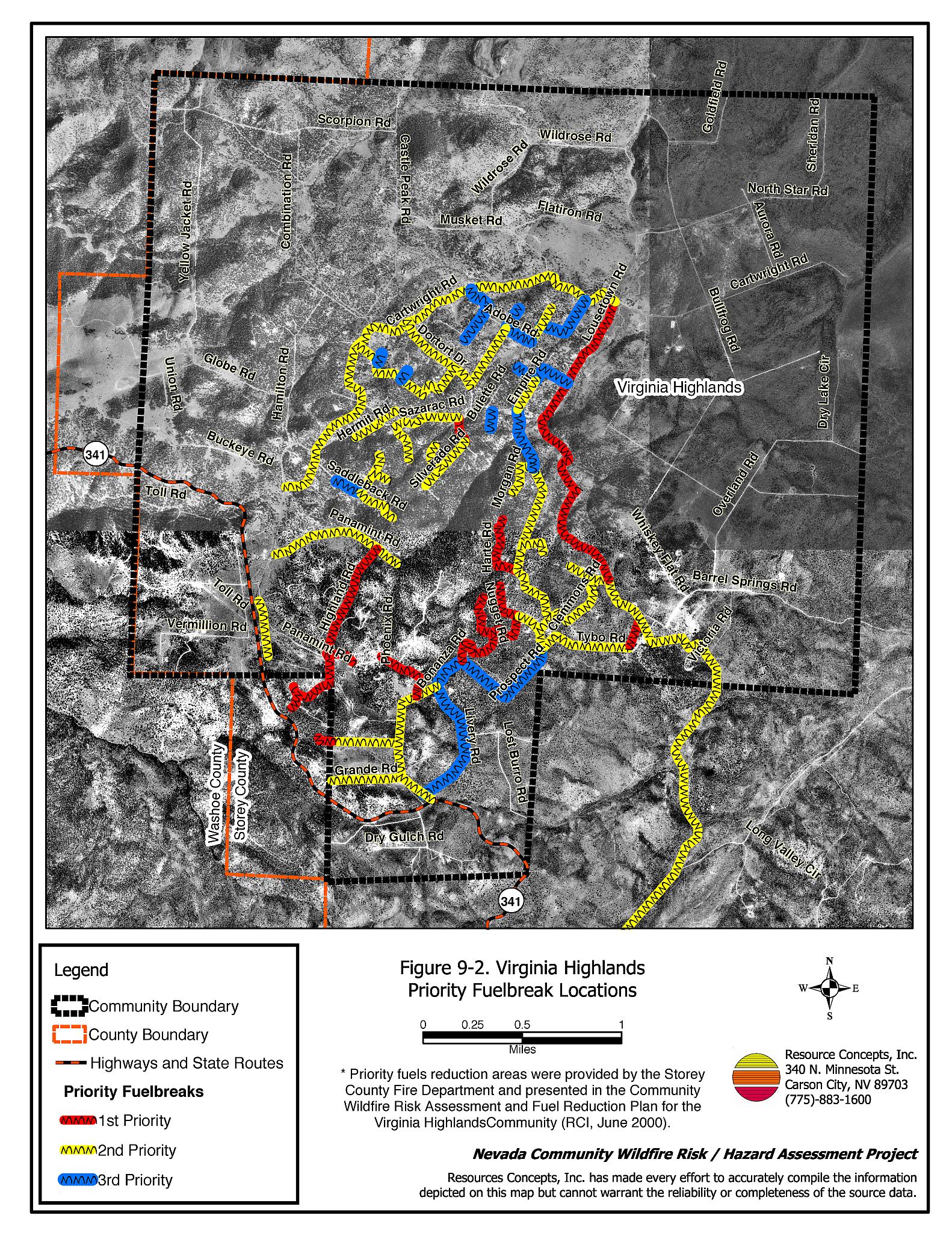
Specifications for the recommendations pertaining to fuelbreaks recommended by Resource Concepts, Inc. (2002) are summarized in Tables 9-1 through 9-4 and shown in Figure 9-2. Perimeter fuelbreaks are planned for Cartwright Road and proposed for Yellowjacket Road and Highway 341 for the fall of 2004 through the spring of 2005.
The Storey County Fire Department prioritized several internal fuelbreak recommendations for the Virginia Highlands community. At the time of this report, the homeowner support on parcels that would be affected by internal fuelbreaks was around fifty percent (J. Copeland, pers. comm.). This observation indicates that efforts to emphasize the importance and effectiveness of internal fuelbreaks will be a necessary prerequisite to the actual implementation of these fuelbreaks in the interior of the community.
9.3 Summary of Recommendations for Virginia Highlands
The following recommendations are summarized from RCI 2002 Community Wildfire Risk Assessment and Fuel Reduction Plan for the Virginia Highlands Community.
| Responsible Parties |
Recommendations |
|---|---|
| Nevada Division of Forestry Fire Safe Highlands |
Construct shaded fuelbreaks a minimum of 200 feet wide along the following existing roads: Cartwright Road, Lousetown Road, segments of Hwy 341 that traverse the P-J woodland, Sazarac to Empire, and north to Agate and on to Lousetown. Seek to extend Saddleback to Lousetown Road to provide a continuous fuelbreak. Extend less intensive tree and shrub treatment for an additional 25 feet. |
| Property Owners | Thin trees and shrubs along driveways similar to the recommendations for roadside fuelbreaks. See the RCI Highlands Report (2002) for further details. Broadcast seed treated areas with a recommended seed mixture such as included in Appendix E of this report, or Appendix A of the RCI Highlands Report (2002). Refer to the RCI Highlands Report (2002) for detailed specification on creating and maintaining effective defensible space. (Refer to Appendix E of this report for guidelines on defensible space.) Seek advice from the Storey County Fire Department for sheltering on-site. |
| Source: RCI 2002 | |
| Responsible Party |
Recommendation |
|---|---|
| Nevada Division of Forestry Fire Safe Highlands Coalition |
Construct fuelbreaks along Cartwright Road and Lousetown Road that are a minimum distance of fifty feet from the centerline on both sides of the road. Areas dominated by pinyon-juniper should follow the RCI 2002 Highlands Report recommendations for Zone 1. |
| Property Owners | Refer to the RCI 2002 Highlands Report for detailed specification on creating and maintaining effective defensible space. (Refer to Appendix E of this report for guidelines on defensible space.) Broadcast seed with seed mix recommended in Appendix E of this report or Appendix A, Zone 2 of the RCI 2002 Highlands Report to minimize cheatgrass invasion. Clear residential driveways of hazardous fuels and construct pullouts or adequate turning radius to accommodate firefighting equipment. |
| Source: RCI 2002. | |
| Responsible Party |
Recommendation |
|---|---|
| Nevada Division of Forestry Fire Safe Highlands |
Continue the fuelbreak along Lousetown Road by implementing the recommendations for Zone 1 in the RCI Highlands Report (2002). |
| Private Property Owners | Treat private driveways for a minimum distance of fifty feet from centerline on both sides of the road. Remove all dead shrubs and other accumulated biomass to a designated safe area. Refer to the RCI 2002 Highlands Report for detailed specification on creating and maintaining effective defensible space. (Refer to Appendix E of this report for guidelines on defensible space.). Provide adequate space for fire equipment to turn around. Identify addresses with four-inch fluorescent numbers that are readily visible to emergency responders |
| Source: RCI 2002 | |
| Responsible Party |
Recommendation |
|---|---|
| Private Property Owner | Control shrubs and herbaceous vegetation within thirty feet along both sides of driveways. Revegetate all disturbances created from hazard reduction treatment according to the recommendations for Zone 4, given in Appendix 2 of the RCI Highlands Report (2002). Refer to the RCI 2002 Highlands Report for detailed specification on creating and maintaining effective defensible space. (Refer to Appendix E of this report for guidelines on defensible space.). Replace hazardous fuels with fire retardant species or desert landscaping (xeriscape) treatments that incorporate rock or gravel and minimize use of flammable plants. |
| Source: RCI 2002 | |
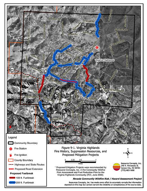
Figure 9-1Virginia Highlands Fire History, Suppression Resources, and Proposed Mitigation Projects |
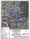 |
Figure 9-2Virginia Highlands Priority Fuelbreak Locations |
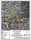 |
Figure 9-3Virginia Highlands Fuel Hazard Classification |
 |
Figure 9-4. Virginia Highlands Fuel Hazard Photo Points
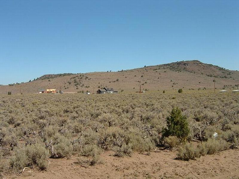
Photo Point 1. 0273891N. 4362936E. Direction 22°NNE. The moderate fuel hazard in this area consists of sagebrush, with some bitterbrush and rabbitbrush. The total fuel load was estimated at less than five tons per acre.
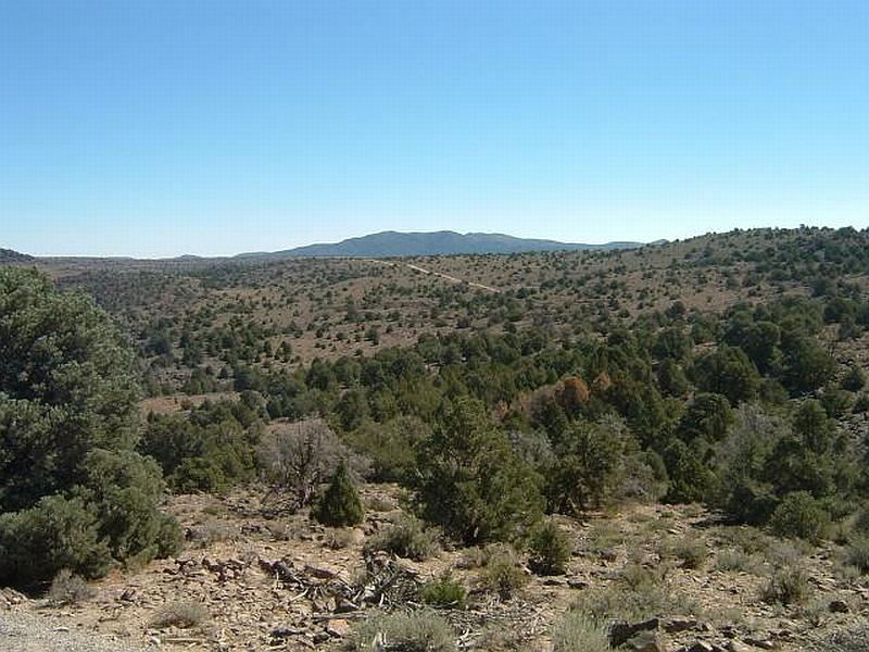
Photo Point 2. 0273376N. 4362234E. Direction 104°ESE. High fuel hazard areas consist of scattered pinyon-juniper woodland cover with some sagebrush and bitterbrush understory. Fuel loading for high fuel hazard areas ranges between four and eight tons per acre.

Photo Point 3. 0273117N. 4360986E. Direction 264°WSW. Extreme fuel hazard in the Virginia Highlands characterized by steep slopes and closed-canopy pinyon-juniper woodlands with understory of sagebrush, bitterbrush, and rabbitbrush. The total fuel load for these areas was estimated at more than eight tons per acre.