![]()
![]()
8.0 Virginia City
8.1 Risk and Hazard Assessment
Virginia City is located at 6,000 feet in the Virginia Range, mid-slope, generally on east facing aspects. The risk assessment resulted in classifying Virginia City in the High Hazard category (75 points). A summary of the factors that contributed to the hazard rating for Virginia City are presented in Table 8-2. The principal factors that influenced this rating were construction materials and the difficult access for fire suppression apparatus, often due to steep, narrow roads and dead ends with no turn-around space. Existing heavy fuels and common downslope winds on the west side of town also contributed to the hazard score.
8.1.1 Community Design
The urban interface condition surrounding Virginia City is intermixed. Structures are scattered throughout the wildland area; there is no clear line of demarcation between wildland fuels, buildings, and open space throughout the community. On the west side of town, the line of demarcation is more clearly defined, approximating a classic interface condition. Nearly all of the 262 structures assessed are on parcels of less than one acre.
- Roads: State Routes 341 and 342 provide the primary access routes for the community. These roads are at least 24 feet wide, paved, and have adequate turnaround space for fire suppression equipment. Twelve percent of the secondary roads have grades steeper than five percent, which makes access difficult for suppression vehicles, especially those loaded with water.
- Signage: Street signs were present along all of the streets. Residential addresses were easily visible on roughly half of the houses.
- Utilities: All of the utilities are above ground. Many areas beneath power lines were in need of vegetation clearing and thinning.
8.1.2 Construction Materials
Approximately 78 percent of the homes assessed were built with non-combustible siding materials; nearly all of the homes have fire resistant (composition, metal, tile) roofing materials. Sixty-five percent of the homes observed had unenclosed balconies, porches, decks, or other architectural features that can create drafts and provide areas where sparks and embers can accumulate, smolder, ignite, and rapidly spread fire to the home.
8.1.3 Defensible Space
The vegetative fuel loading in the Virginia City interface area is generally moderate. Fuels in the community consist primarily of sagebrush with inclusions of bitterbrush, rabbitbrush, desert peach, and cheatgrass. The terrain is steep with some slopes approaching eighty percent on the west side of town. Approximately thirty percent of the homes surveyed have landscaping that would meet the minimum requirement for defensible space to help protect the home from damage or minimize loss during a wildfire.
8.1.4 Suppression Capabilities
Wildfire Protection Resources
Storey County Fire Department Station #1 is located in Virginia City. At the time of inquiry, fire personnel included the fire chief, six career firefighters, seventeen volunteers, and the fire apparatus listed in Table 4-2 (G. Hames, pers. comm.). Resource availability and mutual aid agreements with the Storey County Fire Protection District are described in Section 4.1.1.
Water sources and Infrastructure
Virginia City has a variety of water resources:
- There are 500 gpm hydrants within 500 feet of the structures
- There are several water tanks totaling 3 million gallons. A new 2 million gallon tank will be installed in 2005 in Virginia City.
The community water system is operated by electric pumps and gravity flow. The pumps have an emergency electric generator for back up. The fire main flow is 3,000 gpm per hydrant. The water systems meet or exceed the current codes.
8.1.5 Factors Affecting Fire Behavior
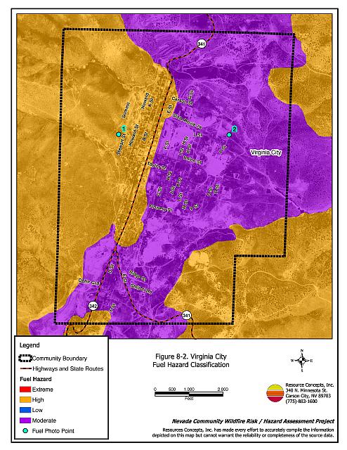
The fire behavior potential in Virginia City is high on the west side of town. Continuous fuels in close proximity to structures and a fuel composition that includes a shrub layer with grass understory create the potential for high intensity surface fires. Slopes in the area reach eighty percent, with some south aspects that effectively preheat and dry vegetation during the day. Several past fires in the vicinity of Virginia City have destroyed and damaged buildings in the community. The location of Virginia City relative to the east facing slopes of Mt. Davidson, the Virginia Range, and Six Mile Canyon enhances its vulnerability to the predominant winds from the west that frequently blow downslope. Fuels in the area are mostly sagebrush, bitterbrush, desert peach, rabbitbrush, and cheatgrass. Fuels are moderately dense and shrubs are two to three feet in height. Fuel loading was estimated to be less than four tons per acre and was considered a high fuel hazard.
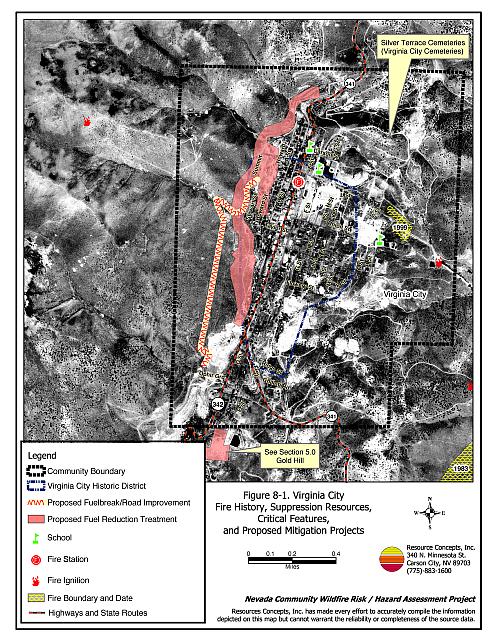
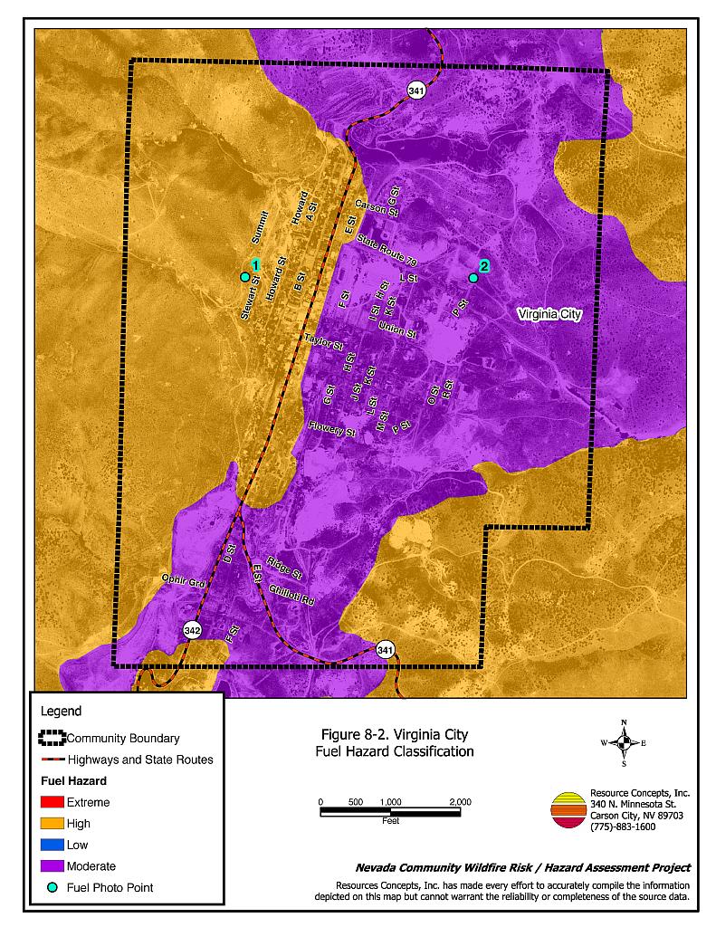
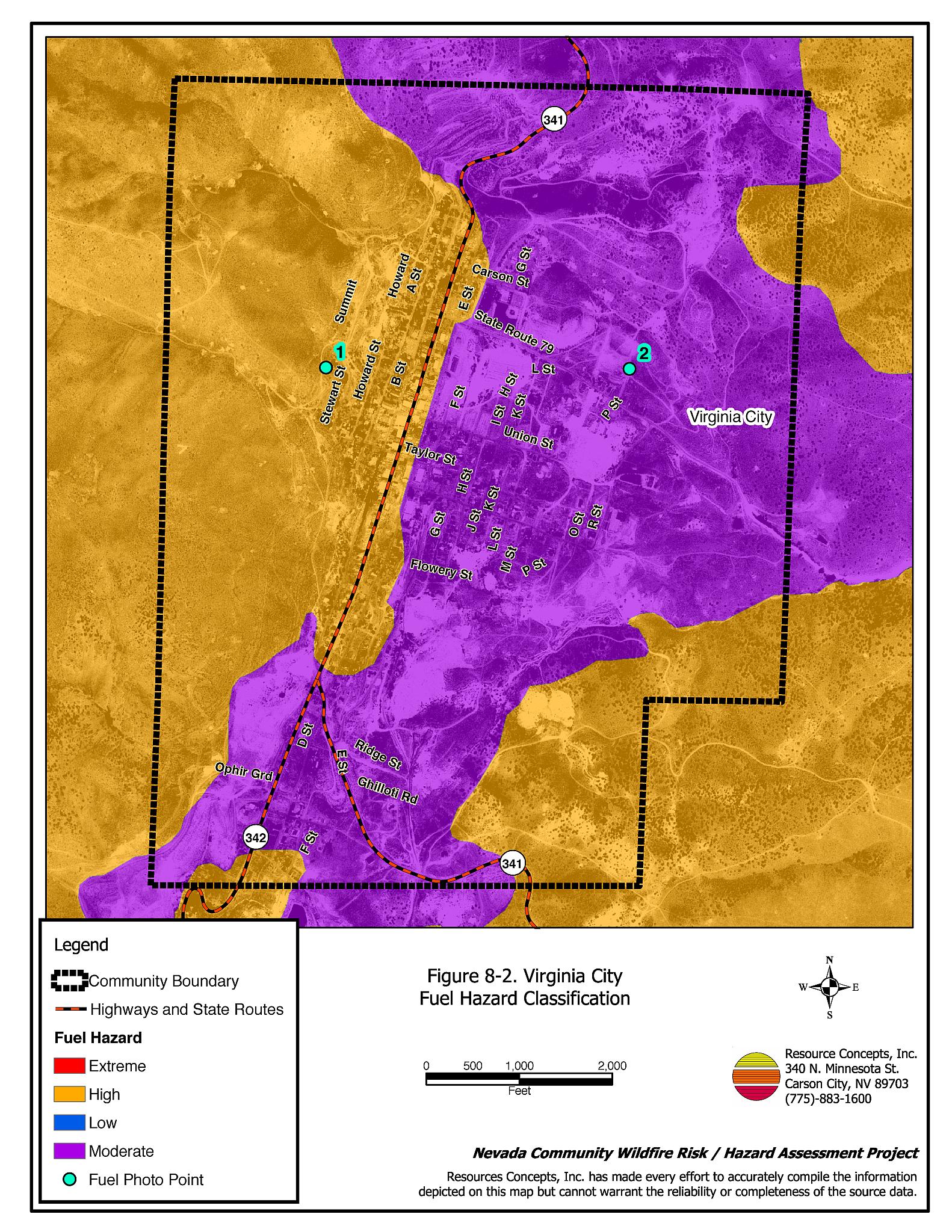
Fuels on the east side of town are discontinuous and interrupted by large expanses of mine tailings. Existing fuels in this area have been greatly reduced from past fires. A map of the fuel hazard condition for Virginia City is shown in Figure 8-2. Photographs of fuel conditions in the Virginia City interface area are included in Figure 8-3.
8.1.6 Fire Behavior Worst-Case Scenario
The worst-case wildfire scenario would be a fire that starts mid-afternoon during the summer months with dry lightning and a 25 to 35 mph wind. The possibility of lightning strikes in the area is high and afternoon downslope winds are common. A strike occurring in the drainage at the west end of Taylor Street, with west winds, would drive the fire east, causing a downslope fire that would rapidly spread into homes on the west side of town. High tourist volumes during the summer months are the cause for a serious evacuation concern. Gridlock from chaotic evacuation and poor visibility from smoke would exacerbate the problem and limit access by emergency vehicles, both local and those called in from automatic mutual aid and interagency dispatch.
The concern from a wildfire approaching on the east side of town burning upslope in Six Mile Canyon would be focused on firebrands. Burning embers blowing into town could ignite numerous spot fires around old wooden structures that could escalate into a catastrophic fire if not controlled and extinguished quickly by firefighters patrolling in town. The advancing fire burning upslope in Six Mile Canyon would be slowed when it reached mine tailings and low density fuels in previously burned areas. If the fire moved into Six Mile Canyon and burned upslope in a northwest direction it would miss the community of Virginia City. Fire and smoke under these circumstances would block two of the three evacuation routes out of town and limit emergency access to Virginia City.
8.1.7 Ignition Risk Assessment
Virginia City has a high ignition risk due to the high number of summertime visitors to the area. Human caused ignitions can come from a variety of sources. Fires can be started along highways and county roads by burning material thrown out of vehicle windows or as a result of auto accidents. The dirt roads and trails around Virginia City are commonly used by off-road vehicles. Based on ignition history data, the ignition risk from lightning strikes in the Virginia City area is low to moderate.
8.2 Risk and Hazard Reduction Recommendations and Responsibilities
The priority recommendations for Virginia City are for defensible space. Fuel reduction on the west side of town is designed to complete a continuous “fuelbreak” around the community in conjunction with existing mine tailings and old burns. Specific recommendations and responsibilities are summarized in Table 8-1.
8.2.1 Defensible Space
Defensible space treatments are an essential first line of defense for residential structures and are especially critical for those homes along the west side of Virginia City. The density and type of fuel around a home determines the potential fire exposure levels to the home. The goals of defensible space are to reduce the risk of property loss from wildfire by eliminating flammable vegetation near the home, thereby lowering the potential to burn and providing firefighters a safer working area from which to defend the home or outbuilding during a wildland fire. Guidelines for improving defensible space around residences and structures in the community are given below and in Appendix E.
Property Owner Responsibilities
- Remove, reduce, and replace vegetation to create defensible space around homes according to the guidelines in Appendix E. This area should be kept:
- Lean: There are only small amounts of flammable vegetation,
- Clean: There is no accumulation of dead vegetation or other flammable debris, and
- Green: Existing plants are healthy and green during the fire season.
- Clear weeds and brush to a width of ten feet along both sides of the driveways. Install turnouts and ensure space to turn around on long private driveways.
- Thin trees and shrubs to a spacing equal to twice their height.
- Prune remaining trees so that branches are at least fifteen feet away from buildings, especially near chimneys. Prune and remove all dead and diseased branches from trees. Remove pine needle duff from beneath remaining trees.
- If possible, irrigate all remaining trees and large shrubs in close proximity to structures to increase their fire resiliency. This is especially important during drought conditions.
- Maintain a minimum clearance distance of thirty feet from the crown of trees to structures and other tree crowns that remain within the defensible space zone. Keep this area free of smaller trees, shrubs, and other ladder fuels.
- Clear brush and weeds away from propane and oil tanks for a minimum distance of ten feet.
- Mow, prune, or removebrush growing within ten feet of fences in the community.
- Immediately dispose of cleared vegetation when implementing defensible space treatments. This material dries quickly and poses a fire hazard if left on site.
- Store firewood a minimum distance of thirty feet from structures.
- Maintain areas under wood decks and porches free of weeds and other flammable debris. Install screens around unenclosed overhangs where possible.
- Maintain this defensible space as needed.
8.2.2 Community Coordination
Many of the most effective activities aimed at reducing the threat of wildfire for the Virginia City Community require that individual property owners coordinate with each other and with local fire authorities. Effective defensible space, for example, is more effective in small communities when applied uniformly throughout entire neighborhoods. Public education and awareness, neighbors helping neighbors, and proactive individuals setting examples for others to follow are just some of the approaches that will be necessary to meet the fire safe goals in Virginia City. Disposal of biomass generated from defensible space treatments can sometimes be most efficiently handled through community programs.
Property Owner Responsibility
- Form a local chapter of the Nevada Fire Safe Council. The Nevada Fire Safe Council facilitates solutions to reduce the loss of lives and property from wildfire in Nevada’s communities. Through the establishment of a local Chapter, local communities will become part of a large network for sharing information, including notification of programs and funding opportunities for fire mitigation projects such as those listed in this report. The Nevada Fire Safe Council will accept and manage grants and contracts on the Chapter’s behalf through its non-profit status. The Nevada Fire Safe Council will provide assistance and support to communities to complete fire safe plans, set priorities, educate and train community members and promote success stories of its members. To form a local Chapter or for more information contact the:
Nevada Fire Safe Council
1187 Charles Drive
Reno, Nevada 89509
(775) 322-2413
www.nvfsc.org
- Assure that address signs are visible from the road. Address characters should be at least four inches high, reflective, and composed of non-flammable material. Improving visibility of addresses will make it easier for those unfamiliar with the area to navigate under smoky conditions during a wildland fire.
- Read and become fully knowledgeable of evacuation procedures, fire safety zones, and safety procedures for sheltering in place in the event that evacuation is not possible.
Storey County Fire Department Responsibilities
- Organize community clean-up events to remove weeds and debris in town. Facilitate community projects to dispose of accumulated biomass.
Storey County Commissioner Responsibilities
- Require all future development in the County to meet the national fire codes with regard to community design aspects, building construction and spacing, road construction and design, water supply, and emergency access. Refer to Appendix F for an example of fire safe recommendations for planning new developments.
8.2.3 Fuelbreaks and Fuels Reduction Treatments
Fuel reduction treatments, including shrub thinning are recommended on approximately ten acres along the western interface (See Figure 8-1). These treatments are recommended to permanently change the fuel structure over large blocks of land. With a fuel reduction treatment, the expected result in the event of a catastrophic wildfire would be one of reduced probability for uncontrolled spread through the treated area. Fuelbreaks can stop or slow the advance of a wildfire and give firefighters a place to stand against an oncoming fire. Fuels reduction treatments are applied on a larger scale than defensible space treatments and generally reach beyond private land boundaries.
Storey County Fire Department
- Coordinate with private property owners, the Nevada Division of Forestry, and the BLM to create a fire access road along the west side of Virginia City by grading and widening the existing Summit Road and adding turn-around locations to allow passage of fire suppression equipment. In addition to improving the existing road, increase the vegetation clearance area along Summit Road by an additional thirty feet on each side of the roadway for a distance of approximately 6,000 lineal feet.
- Coordinate with private property owners, the Nevada Division of Forestry, and the Bureau of Land Management to implement a fuels reduction treatment on approximately 63 acres below Summit Road and the edge of the residential area. Thin trees to create openings of at least thirty feet between tree crowns. Remove ladder fuels and thin shrubs to a spacing equal to twice their height. Revegetate the treatment area with the seed mixture and procedures given in Appendix E to prevent establishment of cheatgrass and other noxious weeds.
Utility Company Responsibilities
- Maintain power line corridors by clearing flammable vegetation within fifteen feet of power poles, as fires have been known to start from arcing power lines during windy conditions or exploding transformers during periods of high electricity use.
Storey County and Nevada Department of Transportation Responsibilities
- Reduce and remove fuels along county roads, State Routes, and highways using brush hogs or mowers to reduce vegetation height to four inches for a distance of 25 feet on both sides of the road or to the fenced right-of-way boundary.
8.2.4 Public Education
Public education about fire safety is critical. A program that explains fire safe measures in clear and emphatic terms will have an impact on residents of the wildland-urban interface. Informed community members will be more inclined to make efforts in effectively reducing the wildfire hazards to their homes and neighborhoods. People moving into the area may be unfamiliar with standard precautions that must be taken when living in a fire-prone environment. Working with local fire officials, residents can learn to identify fire hazards in the wildland-urban interface and take effective action to remedy those hazards in Virginia City.
Storey County Fire Department
- Complete and distribute copies of the Virginia City emergency evacuation plan to all residents. Conduct public workshops annually prior to the tourist and fire season to ensure that all residents are fully knowledgeable of evacuation routes, evacuation procedures, designated fire safe zones, and procedures for sheltering in place in case evacuation becomes infeasible during a fast moving fire storm.
- Post the evacuation plan in parking lots and elsewhere throughout Virginia City to inform tourists of appropriate evacuation procedures.
- Distribute copies of the publication Living with Fire to all property owners. This publication is free of charge. Copies can be requested from the University of Nevada Cooperative Extension.
- Enforce or develop county laws, regulations, and ordinances that support implementation and maintenance of defensible space and establish fuel reduction responsibilities for absentee homeowners and vacant lots.
- Contact the University of Nevada Cooperative Extension and the BLM Carson City Field Office for assistance with public education.
8.3 Summary of Recommendations
| Responsible Party |
Recommended Treatment |
Recommendation Description |
|---|---|---|
| Property Owners | Defensible Space | Remove, reduce, and replace vegetation around home according to the defensible space guidelines in Appendix E. |
| Community Coordination | Form a local chapter of the Nevada Fire Safe Council. Improve address visibility. Participate in public education opportunities and become knowledgeable of emergency evacuation procedures. |
|
| Utility Company | Fuels Reduction | Reduce and remove vegetation in power lines corridors. Maintain fifteen feet of clearance around utility poles. |
| Storey County And NDOT |
Fuels Reduction | Reduce and remove vegetation in county road, state route, and highway right-of ways to maintain an average four-inch vegetation height. Reseed with the recommended seed mixture given in Appendix E to minimize opportunities for cheatgrass and noxious weed invasion. Facilitate removal of biomass generated from fuel reduction projects. |
| Storey County Fire Department Nevada Division of Forestry Bureau of Land Management |
Fuels Reduction | Grade Summit Road for a distance of approximately 6,000 lineal feet to create a fire safe access road on the west side of the community Clear vegetation an additional thirty feet on the uphill side of the road. Implement a fuels reduction treatment on approximately 63 acres. |
| Storey County Fire Department | Public Education | Complete and distribute the Virginia City emergency evacuation plan. Conduct annual workshops to train residents on evacuation procedures and safety procedures for sheltering in place. Post the evacuation plan throughout the community to inform tourists of evacuation procedures. Organize community clean-up projects and facilitate biomass removal from treatment areas. Enforce or develop county laws, regulations, and ordinances for defensible space and fuel reduction that include responsibilities for absentee homeowners, vacant lots, and new subdivisions. Distribute copies of the publication “Living with Fire” to all property owners. Contact the Nevada Cooperative Extension and the Bureau of Land Management for assistance with public education. |
| Storey County Commissioners | Community Coordination | Require all future development in the County meet the national fire codes with regard to community design aspects, building construction and spacing, road construction and design, water supply, and emergency access. |
Figure 8-1Virginia City Fire History, Suppression Resources, Critical Features, and Proposed Mitigation Projects |
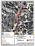 |
Figure 8-2Virginia City Fuel Hazard Classification |
 |
Figure 8-3. Virginia City Fuel Hazard Photo Points
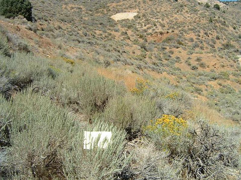
Photo Point 1. 0271370N. 4354566E. Direction 28°NNE. Total fuel loading on the west side of Virginia City is estimated at less than four tons per acre. Vegetation consists of sagebrush, rabbitbrush, cheatgrass, and native grasses with occasional pinyon and juniper trees. The vegetative fuel hazard is rated as high due to its position at the base of the Virginia Range on steep slopes that experience frequent downslope winds.
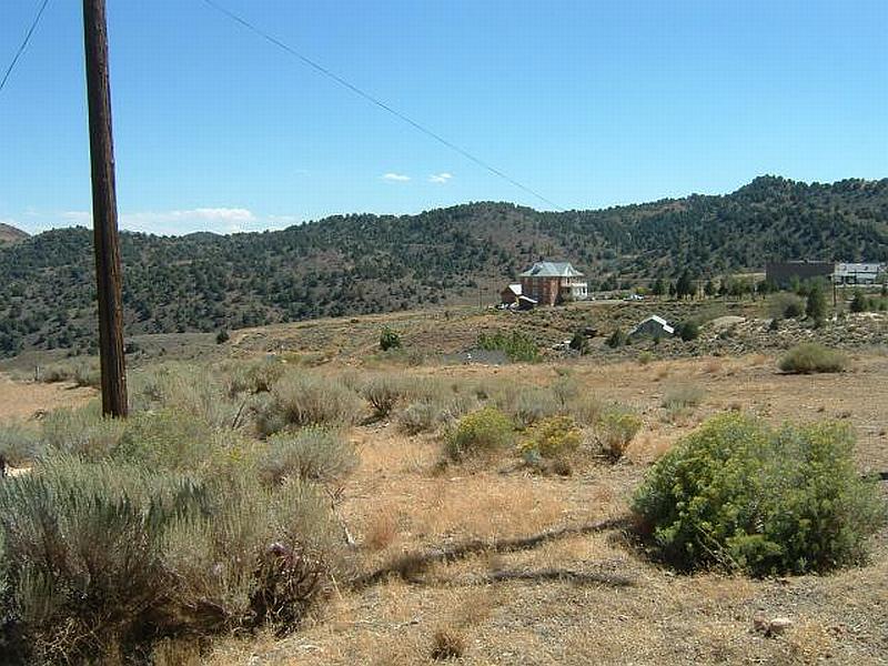
Photo Point 2. 0272365N. 4354562E. Direction 164°SSE. The fuels on the east side of the community are characterized by a light cheatgrass component, sparse sagebrush, and rabbitbrush. Historic mining activity and other disturbances create a highly fragmented fuel bed. Fuel loading is estimated at less than two tons per acre and has a hazard rating of moderate.
Figure 8-2Virginia City Wildfire Hazard Rating Summary |
 |