![]()
![]()
20.0 Pine Nut Creek
20.1 Blackbull Wildfire Services Hazard and Risk Assessment
In 2004, Blackbull Wildfire Services completed an assessment entitled “Community Wildfire Threat Reduction and Project Implementation Plan for Pine Nut Creek, September 2004,” on behalf of the Nevada Fire Safe Council. The pertinent information for this report is summarized from the Blackbull Pine Nut Creek assessment.
The Pine Nut Creek community is located approximately eleven miles east of Gardnerville, Nevada. A majority of the residences and one non-profit organization (City of Refuge) are located along Pine Nut Creek, southeast of the community of Fish Springs at approximately 5,500 feet in elevation. The property adjacent to the community is public land and Tribal Trust lands. Five homes and the non-profit organization buildings were included in the assessment. The assessment resulted in classifying the Pine Nut Creek community in the High Hazard category. The primary factors that affected the Pine Nut Creek community hazard score were hazardous vegetative fuels, road conditions, the absence of street and address sighs, and construction materials.
20.1.1 Community Design
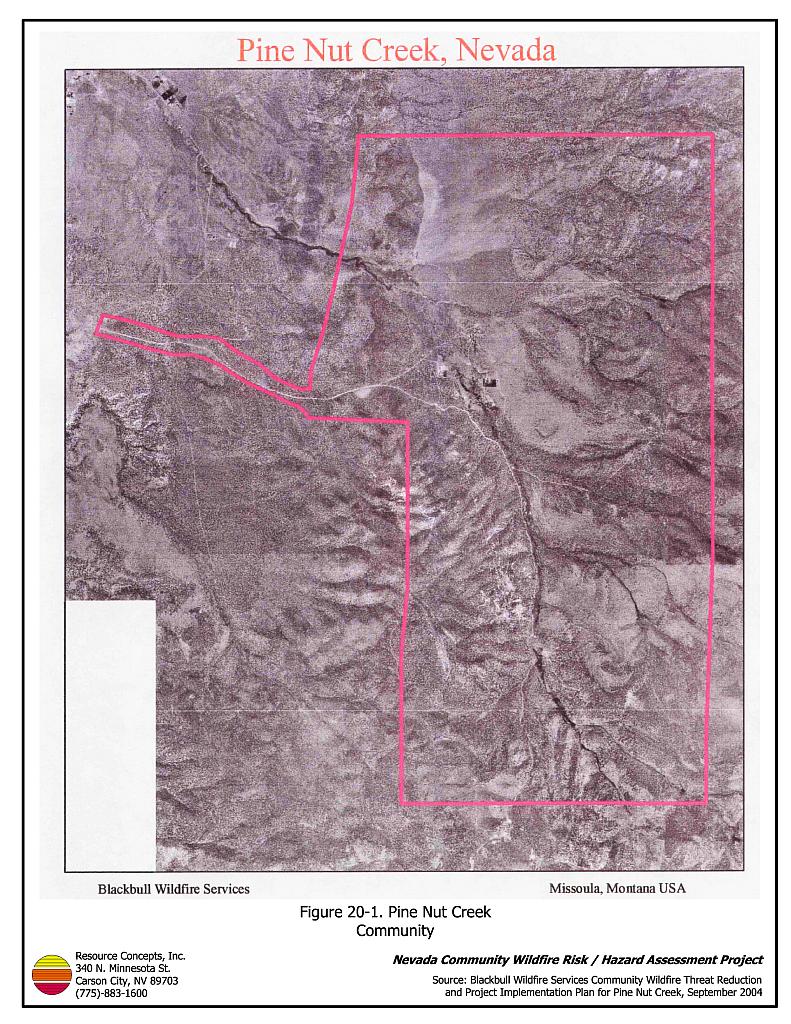
The Pine Nut Creek interface area is characterized by the intermix wildland-urban interface condition. Structures are scattered throughout the wildland area with no clear line of demarcation between wildland fuels and residences in the community (see Figure 20-1).
- Roads: Pinenut Road II is the primary road connecting the Pine Nut Creek community with other communities in Douglas County. Secondary community roads include Lena Lane and Qadosh Road. Other residences are interspersed along unpaved roads and driveways along Pine Nut Creek. Most roads in the community are unpaved, are less than twenty feet in width, and have grades greater than five percent, conditions that may limit the ability for fire suppression equipment to maneuver or turn around in the community.
- Signage: Street signs were not present along a majority of streets in the Pine Nut Creek community. Clear and visible residential addresses and street signs are important to aid firefighting personnel in locating homes during low visibility conditions that occur during a wildland fire.
- Utilities: Public utilities servicing the five houses on Lena Lane and Pinenut Road are both above and below ground.
20.1.2 Construction Materials
A majority of the homes in the community were built with fire-resistant siding and Class C roofing materials.
20.1.3 Defensible Space
A majority of the homes assessed had between thirty and seventy feet of defensible space vegetation treatment surrounding the structure, much less than the recommended minimum defensible space distance of 100 to 200 feet depending upon slope. Refer to Appendix D for standard defensible space recommendations.
20.1.4 Fire Suppression Resources
Wildfire Protection Resources
The Fish Springs Volunteer Fire Department (Station 9) of the East Fork Fire and Paramedic District is responsible for wildfire and structure fire protection in the Pine Nut Creek community. At the time of the assessment, the Fish Springs VFD listed twenty volunteers on its roster (East Fork Fire Protection District website). See Tables 4-2 and 4-3 for more information on the typical fire suppression response for first-alarm wildland-urban interface fires in Douglas County. Appendix E lists the type and number of fire suppression vehicles located at each EFFPD and Douglas County VFD station.
The BLM / Interagency wildland fire resources will also respond to all wildland fire reports within the Pine Nut Creek community. BLM has a wildland fire engine stationed at the Fish Springs VFD (Station 9) to respond to risks to adjacent public land and Indian allotment lands. The response will be initiated by the Sierra Front Interagency Dispatch Center.
Water Sources and Infrastructure
No hydrants are available within the community. One 18,000 gallon water tank is available as a drafting source at the Fish Springs VFD, which is approximately five miles away. A 240,000 static fill tank is located on Jo Lane in the East Valley community that can be used as a drafting source. There are several helicopter dip sites in the area that are known to local residents but are not mapped or included in any written form.
Community Preparedness
The Pine Nut Creek community formed a local chapter of the Nevada Fire Safe Council in July of 2003 with a current roster of seventeen members. There is currently no evacuation plan for residents of the community, nor do the emergency and disaster plans provide information on safe zones within the community.
20.1.5 Factors Affecting Fire Behavior
Vegetation, dead and down fuels, and topographic features contribute to the potential fire hazard around wildland-urban interface communities. The terrain in the community is generally flat where the residences are located; however, steeper hills, draws, and canyons surround the residences. There is a significant history of large fires and fire ignitions near the community.
The vegetation in the Pine Nut Creek community was classified as a high hazard fuel type, dominated by pinyon pine, Utah juniper, and big sagebrush. The pinyon Ips beetle has caused mortality of many of the pinyon trees in the area, dramatically increasing the fire hazard when the trees are in the “red stage” (when needles have dried out, but have not yet fallen off the tree).
20.1.6 Fire Hazard Reduction Projects
In 2004 the BLM Carson Field Office funded a Student Conservation Association Fire Education Corp Team that completed evaluations of defensible space conditions and provided Pine Nut Creek homeowners with defensible space educational materials.
The Bureau of Land Management Carson City Field Office is currently implementing a fuel reduction treatment at the north end of the Pine Nut Creek community along Pine Nut Road II from Out-R-Way to Lena Lane (see Figure 11-2 in the Fish Springs section). The project area was first initiated by opening the area to public woodcutting between October 2004 and January 2005. Project specifications for the two treatment areas include using mechanical mastication equipment to reduce tree and shrub density by removing roughly ninety percent of the shrub and tree cover in the area. The mastication treatment is scheduled to be completed by May 2005.
The BLM has provided grant funding to the local Nevada Fire Safe Council for fuels reduction treatments on private lands within the community. A perimeter shaded fuelbreak and fuels reduction along community roads is planned for 2005, utilizing mechanical mastication equipment. Trees will be thinned to a density of 30 to 40 trees per acre, shrubs removed, and limbs pruned within four feet of the ground on remaining trees in the treatment areas.
20.1.7 Fire Behavior and Worst Case Scenario
The worst-case scenario for a wildland fire in the Pine Nut Creek community would start with multiple dry lightning ignitions near the south or southwest end of the community on a high hazard day. Strong south or southwest winds, 25 miles per hour or greater, would push the fire front down Pine Nut Creek. If a fire under this situation blocked Pine Nut Road II, both evacuation and fire suppression could be jeopardized.
20.1.8 Ignition Risk Assessment
The risk assessment resulted in assigning Pine Nut Creek with a high ignition risk rating. A significant history of wildfire and fire ignitions exists in the Bureau of Land Management administered lands and private lands surrounding the community. High ignition rates are likely due to the high fuel loads in and around the community, the tendency for lightning storms during the summer, and the number of people using the wildlands near Pine Nut Creek.
20.2 Risk and Hazard Reduction Recommendations
The Pine Nut Creek risk and hazard reduction recommendations focus on improving defensible space and promoting homeowner responsibilities. Other recommendations pertain to community coordination efforts that could be initiated to enhance the fire safe nature of the Pine Nut Creek community. Recommendations developed by Blackbull (2004) are detailed below. The RCI Project Team supports these recommendations.
20.2.1 Defensible Space
The following recommendations for defensible space are in addition to the other recommendations developed by Blackbull (2004). Defensible space treatments are an essential first line of defense for residential structures. Significantly reducing or removing vegetation within a prescribed distance from structures (100 to 200 feet depending upon slope) reduces fire intensity and improves firefighter and homeowner chances for successfully defending a structure against an oncoming wildfire.
Property Owner Recommendations
- Remove, reduce, and replace vegetation to create defensible space around homes according to the guidelines in Appendix D. This area should be kept:
- Lean: There are only small amounts of flammable vegetation,
- Clean: There is no accumulation of dead vegetation or other flammable debris,
- Green: Existing plants are healthy and green during the fire season.
- Remove debris and flammable materials from within the defensible space area.
- Store firewood a minimum distance of thirty feet from structures.
- Mow or remove brush for a distance of 25 feet along each side of wood or vinyl fences in the community.
- Cheatgrass or other annual grasses that have become dominant within the defensible space zone should be mowed or treated with an application of pre-emergent herbicide prior to seed set. Treatments may need to be repeated the following year to ensure that the seed bank of unwanted grasses has been depleted. Refer to Appendix D for recommended seed mixes and planting guidelines that can be used in conjunction with removal of this annual grass.
- Maintain areas under wood decks and porches free of weeds and other flammable debris. Enclose these areas wherever possible.
- Clear all vegetation and combustible materials around propane tanks for a minimum of ten feet.
- Remove or properly board up abandoned trailers and mobile homes to prevent sparks from entering and igniting the structures.
- Install spark-arresting devices on chimneys.
- Thin pinyon and juniper trees in the defensible space area such that tree canopies are spaced a minimum distance of thirty feet from any other trees, shrubs, or residential structures. Limb branches of remaining pinyon and juniper trees within the defensible space area a minimum of four feet from the ground, or no more than one-third of the tree height. Reduce the needle and cone duff from under the remaining trees to a depth no greater than one-inch.
- Irrigate all trees and shrubs in close proximity to structures to increase their fire resiliency, especially during drought conditions.
- Immediately dispose of cleared vegetation when implementing defensible space treatments. This material dries quickly and poses a fire hazard if left on site.
- Maintain this defensible space as needed to keep the space lean, clean, and green.
20.2.2 Fire Suppression Capabilities
East Fork Fire and Paramedic Districts Recommendations
- Inventory and map known water sources. Identify these locations with signs identifying them as fire suppression drafting sites. Install additional 8,000 to 10,000-gallon dry hydrants in various locations throughout the community.
- Develop a pre-attack plan for the Pine Nut Creek community. The plan should include information regarding the location of water sources, helibases, resident safety zones, locations of recent fuel reduction treatments, and other fire protection facility information.
- Develop a community fire notification and evacuation plan for the Pine Nut Creek Community, including notification plans for homeowners and recreation users.Ā Install permanent signs showing clear ingress and egress routes within the community in areas of high use by mountain bikers and ATV users.
20.2.3 Fuel Reduction Treatments
Nevada Fire Safe Council and Bureau of Land Management Recommendation
- Construct a fuel reduction treatment along Pine Nut Road II from the private land in T12N R21E, Section 13 to the Sheep Camp Junction. Plant the treated area with a fire resistant seed mixture such as the one recommended in Appendix D to control cheatgrass an noxious weed invasion.
East Fork Fire and Paramedic Districts, Bureau of Land Management, and Property Owner Recommendations
- Complete the BLM fuel reduction treatment in progress for Pine Nut Road II from Out-R-Way to Lena Lane including the Lena Lane mastication treatment (scheduled for completion in May 2005). Seed treated area with native and introduced perennial grass species to discourage cheatgrass invasion. Refer to Appendix D for recommended seed mixes and planting guidelines.
20.2.4 Community Coordination
East Fork Fire and Paramedic Districts Recommendation
- Distribute copies of the publication “Living With Fire” to all property owners who live in the Pine Nut Creek community. This publication is free of charge. Copies can be requested from the University of Nevada Cooperative Extension.
20.3 Summary of Recommendations
| Involved Party | Recommended Treatment | Recommendation Description |
|---|---|---|
| Property Owners Local Chapter Nevada Fire Safe Council |
Fuel Reduction | Remove, reduce, and replace vegetation around homes according to the defensible space guidelines in Appendix D. Work with EFFPD and BLM to construct proposed fuel reduction treatments. |
| East Fork Fire and Paramedic Districts | Fire Suppression Capability | Develop a community fire notification and evacuation plan and install permanent signs showing clear ingress and egress routes within the community. Inventory known water sources and install additional 8,000 to 10,000-gallon dry hydrants in various locations throughout the community. Develop a pre-attack plan for the Pine Nut Creek community. |
| Community Coordination | Prepare a community-wide fire safe plan for the community. | |
| Bureau of Land Management | Fuel Reduction | Complete the fuel reduction treatment for Pine Nut II Road from Out-R-Way to Lean Lane including the Lena Lane mastication treatment. |
| Nevada Fire Safe Council Bureau of Land Management |
Fuel Reduction | Construct a fuel reduction treatment along Pine Nut II Road from the private land in T12N, R21E, Section 13 to the Sheep Camp Junction. |
Figure 20-1Pine Nut Creek Community |
 |