![]()
![]()
19.0 North Foothill Road Corridor
19.1 Hazard and Risk Assessment
The North Foothill Road Corridor community is located directly south of Genoa and north of Sheridan Acres along Foothill Road on the west side of Carson Valley. The community is situated on east-facing alluvial fans and benches above the Carson River floodplain. The community is partially bordered by US Forest Service lands to the west and by private agricultural lands to the east. Approximately 200 homes were observed in the community during the assessment. The hazard assessment resulted in classifying North Foothill Road Corridor in the High Hazard category (63 points). A summary of the factors that determine this hazard rating is included in Table 19-2. The primary hazards for the North Foothill Road Corridor community are the potential for extreme fire behavior and the proximity of water sources for fire suppression, and the availability of volunteer fire suppression resources.
19.1.1 Community Design
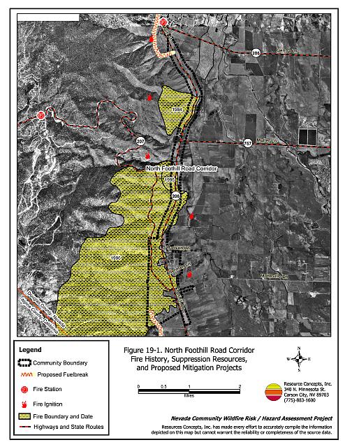
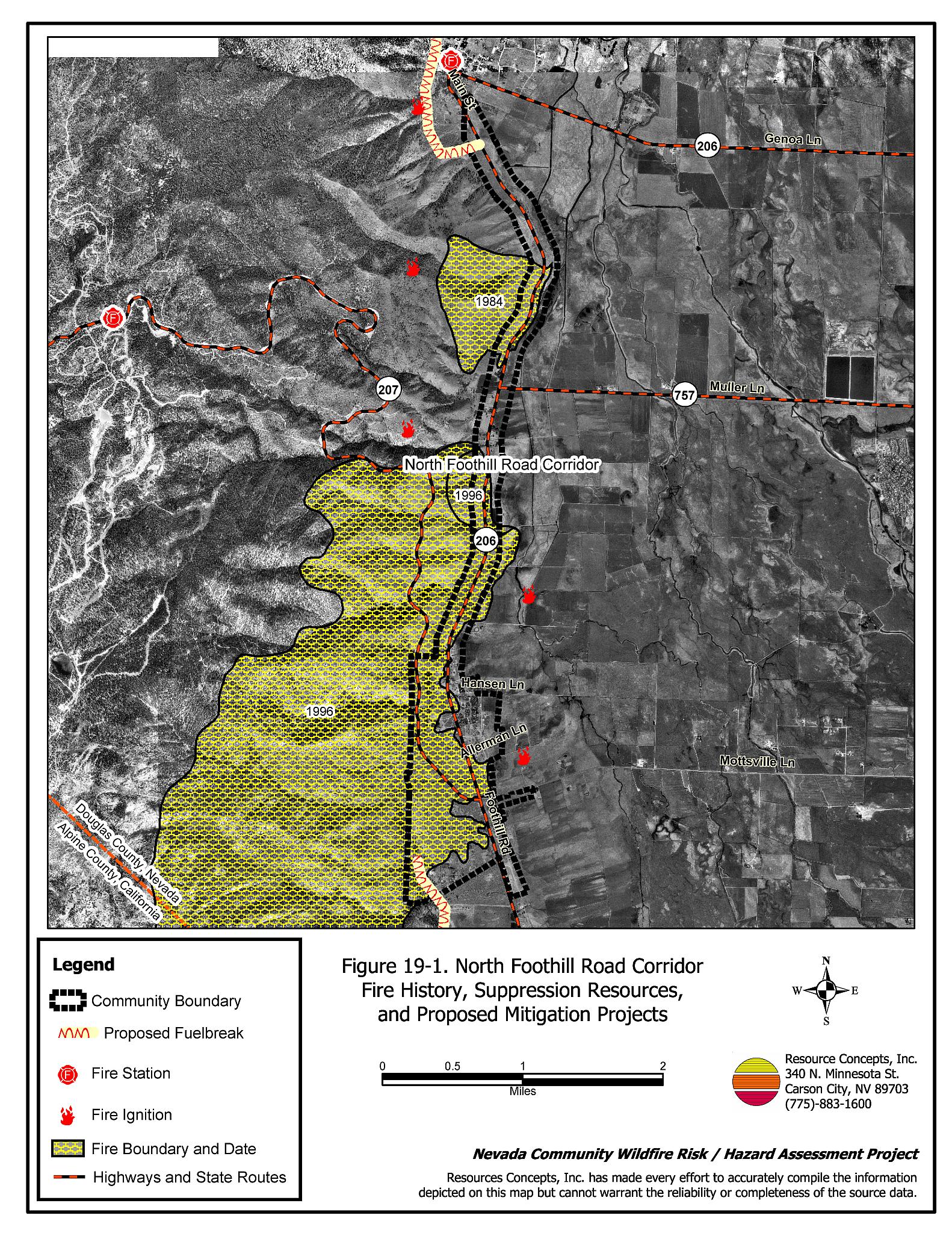
The North Foothill Road Corridor interface area is characterized by the intermix wildland-urban interface condition. Structures are scattered throughout the wildland area with no clear line of demarcation between wildland fuels and residences in the community. All residences observed in the North foothill Road Corridor community were on lots greater than one acre in size (see Figure 19-1).
- Roads: Foothill Road (State Route 206), Muller Lane (State Route 757), Mottsville Lane, and Kingsbury Grade (State Route 207) are the primary roads that provide access between the community and other areas of Douglas County. The roads are greater than 24 feet wide, paved, and provide adequate access for fire suppression vehicles. Most of the secondary community roads have adequate turnaround space for fire suppression equipment. Road grades are less than five percent.
- Signage: Street names were adequately identified throughout the community with reflective signs. Residential addresses were visible on a majority of the homes assessed. Clear and visible residential addresses are important to aid firefighting personnel in locating homes during low visibility conditions that occur during a wildland fire.
- Utilities: Overhead power lines are present within the community. Power line right-of-ways were properly maintained to minimize the possibility of power lines sparking during windstorms and starting fires in nearby vegetation. Propane tanks were also present within the community and sometimes lacked the proper ten feet of vegetation clearance.
19.1.2 Construction Materials
Approximately thirteen percent of the homes assessed had wood shake roofing materials. The remaining 87 percent of the homes assessed were built with fire resistant siding materials and non-combustible roofing materials. About eighteen percent of the homes observed have unenclosed balconies, porches, decks, or other architectural features that create drafts and provide areas where sparks and firebrands can be trapped, smolder, ignite, and rapidly spread fire to the home.
19.1.3 Defensible Space
A majority, 89 percent, of the homes in the interface had landscaping that would meet the minimum defensible space requirement to help protect the home from damage or loss during a wildfire.
19.1.4 Suppression Capabilities
Wildfire Protection Resources
The Nevada Division of Forestry Sierra Forest Fire Protection District, the East Fork Fire and Paramedic Districts Sheridan Volunteer Fire Department Station 8, and Genoa Volunteer Fire Department Station 3 provide wildland and structure fire protection to the North Foothill Road Corridor community. See Tables 4-2 and 4-3 for more information on the typical fire suppression response for first-alarm wildland-urban interface fires in Douglas County. Appendix E lists the type and number of fire suppression vehicles located at each EFFPD station.
Water Sources and Infrastructure
There are no fire hydrants available for residents of the North Foothill Road Corridor community. The nearest drafting sources for fire suppression include a 500,000-gallon tank and a 120,000-gallon static fill tank in the Sheridan Acres community and two tanks with a cumulative capacity of 850,000 gallons in Genoa. For most areas of the community the water sources are at a distance requiring more than a twenty-minute turnaround time. Emergency generators are not available for the pumps on the wells that fill the tanks. Hydrants are available in the Job’s Peak Ranch subdivision located south of the community. The Carson River and ranch ponds may be available for use as helicopter dip sites.
19.1.5 Factors Affecting Fire Behavior
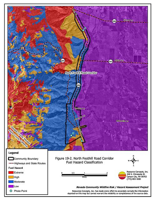
Vegetation, dead and down fuels, and topographic features contribute to the potential fire hazard around wildland-urban interface communities. The fuel hazards were mapped for North Foothill Road Corridor, and fuel hazard photos were taken to provide additional information for the vegetation type descriptions (see Figures 19-2 and 19-3).
The terrain around North Foothill Road Corridor is generally flat with east-facing slopes less than eight percent, however a few small areas of the community lie on slopes in excess of forty percent. Fire ignitions have occurred within the vicinity of the community from both human and lightning causes. The 1996 Autumn Hills Fire burned 3,804 acres at the southwest end of the community. In 1988 approximately 100 acres burned between Kingsbury Grade and Foothill Road. Another fire burned 320 acres on the northwest side of the community in 1984. The predominant wind direction is downslope from the south/southwest, especially in the late afternoon.
Four major vegetation types occur within the vicinity of the North Foothill Road Corridor community including Jeffrey pine/sagebrush, sagebrush/bitterbrush, recovering sagebrush/ rabbitbrush (Autumn Hills fire), and irrigated pasturelands. Irrigated pasturelands are located on the east side of the community, generally east of Foothill Road. They provide an effective greenstrip on the east side of the community and are considered a low fuel hazard.
In the unburned areas within and directly adjacent to the community, the vegetation predominantly consists of big sagebrush, bitterbrush, desert peach, and rabbitbrush. Ground fuels include Indian ricegrass, cheatgrass, and filaree. No ground fuels are present in the Tomerlin subdivision near the south end of the community. Shrubs are dense and shrub heights range between two and eight feet. The fuel load was estimated to be between three and six tons per acre and was considered a moderate fuel hazard.
Further upslope of the community, the vegetation is dominated by a Jeffrey pine overstory, with a shrub and grass understory similar in species composition and density to downslope areas. The fuel loads in the Jeffrey pine area were estimated between four and eighteen tons per acre and were considered an extreme fuel hazard.
Areas of the community burned by the Autumn Hills Fire in 1996 are primarily composed of rabbitbrush, desert peach, cheatgrass, Indian ricegrass and filaree. Shrubs are widely spaced and are less than four feet in height. The fuel load was estimated at two to four tons per acre and considered a moderate fuel hazard.
The unburned areas further north consist of either high-density big sagebrush and rabbitbrush with a cheatgrass understory or big sagebrush, bitterbrush, and rabbitbrush with low density Jeffrey pine. Fuel loads were estimated to range between four and six tons per acre and were considered a high fuel hazard.
19.1.6 Fire Behavior Worst Case Scenario
The worst-case scenario for the North Foothill Road Corridor would likely occur in the event of a dry lightning storm in which several ignitions occurred on the mountain southwest or west of the community. Driven by 25 mile per hour winds, any fire ignition could result in a crown fire capable of rapid spread downhill toward the community, especially north of the Autumn Hills burn where high hazard fuels surround homes. Spot fires could result in multiple fire fronts near residences in the community and could increase the difficulty for fire suppression personnel protecting homes. If Foothill Road were to be closed due to fire or low visibility either between Genoa and Muller Lanes or between Muller and Mottsville Lanes, homeowner evacuation could be limited.
19.1.7 Ignition Risk Assessment
North Foothill Road Corridor has a high ignition risk. Several fires and ignitions have occurred immediately adjacent to the community (Figure 19-1). The predominant ignition risks for North Foothill Road Corridor are lightning and sparking power lines. However, human caused fires can occur at any time.
19.2 Risk and Hazard Reduction Recommendations
The North Foothill Road Corridor risk and hazard reduction recommendations focus on improving defensible space and promoting homeowner responsibilities. Other recommen�dations pertain to community coordination efforts that could be initiated to enhance the fire safe nature of the North Foothill Road Corridor.
19.2.1 Defensible Space Treatments
Property Owner Recommendations
Defensible space treatments are an essential first line of defense for residential structures. Significantly reducing or removing vegetation within a prescribed distance from structures (minimum of 30 feet to 200 feet depending upon slope and vegetative fuel type) reduces fire intensity and improves firefighter and homeowner chances for successfully defending a structure against an oncoming wildfire.
- Remove, reduce, and replace vegetation around homes according to the guidelines in Appendix D. This area should be kept:
- Lean: There are only small amounts of flammable vegetation,
- Clean: There is no accumulation of dead vegetation or other flammable debris,
- Green: Existing plants are healthy and green during the fire season.
- Maintain the area beneath unenclosed wood decks and porches free of weeds and flammabledebris. Enclose these areas wherever possible.
- Clear all vegetation and combustible materials around propane tanks for a minimum distance of ten feet.
- Mow or remove brush growing within a distance of 25 feet and grass within ten feet of wood fences in the community.
- Store firewood a minimum distance of thirty feet from structures.
- Install spark-arresting screens on chimneys.
- Annually remove vegetation and debris along irrigation ditches to reduce the fuel load.
- Remove pine needles, leaves, and debris from roofs and rain gutters.
- Prune tree branches within fifteen feet of chimneys and structures.
- Limb branches of conifers a minimum of fifteen feet from the ground, or no more than one-third of the total tree height, to reduce ladder fuels. All dead and diseased branches and duff should be removed from beneath remaining trees.
- Irrigate all trees and large shrubs in close proximity to structures to increase their fire resiliency, which is especially important during drought conditions.
- Cheatgrass or other annual grasses that have become dominant within the defensible space zone should be mowed or treated with an application of pre-emergent herbicide prior to seed set. Treatments may need to be repeated the following year to ensure that the seed bank of unwanted grasses has been depleted. Refer to Appendix D for recommended seed mixes and planting guidelines that can be used in conjunction with removal of this annual grass.
- Immediately remove cleared vegetation to an approved disposal site when implementing defensible space treatments. This material dries quickly and presents a fire hazard if left on site.
- Maintain this defensible space as needed to keep the space lean, clean, and green.
19.2.2 Fuel Reduction Treatments
Fuel reduction treatments are applied on a larger scale than defensible space treatments. By permanently changing the fuel structure over large blocks of land to one of a lower volume or reduced flammability (a fuel reduction treatment), the expected result in the event of a catastrophic wildfire would be one of reduced capacity for uncontrolled spread through the treatment area.
Property Owner Recommendations
- Reduce vegetative fuels for a distance of ten feet on both sides of private driveways longer than 200 feet. Remove highly flammable shrub species and replace them with fire-resistant species such as crested wheatgrass, lawn, or a pre-suppression seed mix. Appropriate seed mixtures and seeding specifications are provided in Appendix D.
- Coordinate with the Nevada Division of Forestry, EFFPD, and the US Forest Service to construct and maintain the proposed fuelbreak on the southwest side of the community.
East Fork Fire and Paramedic Districts, Nevada Division of Forestry, and US Forest Service Recommendations
- Coordinate with property owners to construct a 400-foot wide shaded fuelbreak for a distance of approximately one-third of a mile on the west side of the community, which ties into the recommended fuelbreak for the Sheridan Acres community. The recommended treatment area is approximately 48 acres (see Figure 19-1). Remove small trees and shrubs within thirty feet of tree drip lines. Thin shrubs outside the drip line to a canopy spacing twice the height of the shrubs. Thin tree stands where necessary (not already thinned) to a minimum basal area of 60 to 80 sq. ft. per acre. For example, where trees in the stand are of an average diameter of 14 inches (DBH), tree spacing should be reduced to approximately 65 trees per acre, with a minimum spacing of 25 feet between tree boles. If the average diameter of trees in the stand is 24 inches (DBH), tree spacing should be reduced to 22 trees per acre, with a minimum spacing of 45 feet between tree boles. Prune lower limbs within fifteen feet of the ground, but do not remove limbs from more than one-third the height of the tree. For more information on tree spacing between boles for various basal areas and tree diameters, refer to Appendix D.
- The biomass generated from construction of the fuelbreak should be removed (piled and burned or transported off the site) and disposed of at an appropriate site. The fuelbreak should be maintained such that there is no significant increase in shrub and tree density from post-treatment levels.
Douglas County Recommendation
- Remove brush for a distance of 25 feet on the west side of Foothill Road. Remove all shrubs with mechanical mastication equipment and then plant fire-resistant perennial grasses and wildflowers. Appropriate seed mixtures and seeding specifications are provided in Appendix D.
Utility Company Recommendation
- Remove trees or trim any tree branches within fifteen feet of either side of power lines and power poles throughout the North Foothill Road Corridor community.
19.2.3 Fire Suppression Capability
Property Owner Recommendation
- Consider purchasing a fire retardant gel or foam product designed for homeowner use. These gels/foams can be applied to structures and vegetation to create an added layer of flame resistance in the event of a fire.
19.2.4 Community Coordination
Many of the most effective activities aimed at reducing the threat of wildfire for the North Foothill Road Corridor require that individual property owners coordinate with each other and with local fire authorities. Defensible space, for example, is more effective in small communities when applied uniformly throughout entire neighborhoods. Public education and awareness, neighbors helping neighbors, and proactive individuals setting examples for others to follow are just a few of the approaches that will be necessary to meet the fire safe goals in the community. Disposal of biomass generated from defensible space and fuel reduction treatments can sometimes be most efficiently handled through community programs.
Property Owner Recommendation
- Form a local chapter of the Nevada Fire Safe Council. The Nevada Fire Safe Council proposes to work on solutions that reduce the risk of loss of lives and property from wildfires in Nevada’s communities. Through establishment of a local Chapter, communities become part of a large information-sharing network that receives notifications of programs and funding opportunities for fire mitigation projects such as those listed in this report. The Nevada Fire Safe Council will accept and manage grants and contracts on the Chapter’s behalf through its non-profit status. The Nevada Fire Safe Council provides assistance and support to communities to complete fire safe plans, set priorities, educate and train community members, and promote success stories of its members. For more information on forming a chapter, contact:
Nevada Fire Safe Council
1187 Charles Drive
Reno, Nevada 89509
www.nvfsc.org
East Fork Fire and Paramedic Districts and Nevada Division of Forestry Recommendation
- Distribute copies of the publication “Living With Fire” to all property owners who live in North Foothill Road Corridor. This publication is free of charge. Copies can be requested from the University of Nevada Cooperative Extension.
19.3 Summary of Recommendations
| Involved Party | Recommended Treatment | Recommendation Description |
|---|---|---|
| Property Owners | Defensible Space | Remove, reduce, and replace vegetation around homes according to the defensible space guidelines in Appendix D. |
| Fuels Reduction | Reduce vegetative fuels for a distance of ten feet on both sides of private driveways longer than 200 feet. Coordinate with the Nevada Division of Forestry, EFFPD, and the US Forest Service to construct and maintain the proposed fuelbreak on the southwest side of the community. |
|
| Fire Suppression Capability | Consider purchasing a fire retardant gel or foam product designed for homeowner use. | |
| Community Coordination | Form a local chapter of the Nevada Fire Safe Council. | |
| US Forest Service | Fuels Reduction | Coordinate with property owners to construct a 400-foot wide shaded fuelbreak for a distance of approximately one mile on the west side of the community, for a total treatment of approximately 48 acres. |
| Douglas County | Fuels Reduction | Remove brush for a distance of 25 feet on the west side of Foothill Road. Remove all shrubs with mechanical mastication equipment, and plant fire-resistant perennial grasses and wildflowers. |
| Utility Company | Fuels Reduction | Remove trees or trim any branches within fifteen feet of either side of power lines and poles throughout the North Foothill Road Corridor community. |
| East Fork Fire and Paramedic Districts Nevada Division of Forestry |
Fuels Reduction | Coordinate with property owners to construct a 400-foot wide shaded fuelbreak for a distance of approximately one mile on the west side of the community, for a total treatment of approximately 48 acres. |
| Community Coordination | Distribute copies of the publication “Living With Fire” to all property owners. |
Table 19-2North Foothill Road Corridor Wildfire Hazard Rating Summary |
 |
Figure 19-1North Foothill Road Corridor Fire History, Suppression Resources, and Proposed Mitigation Projects |
 |
Figure 19-2North Foothill Road Corridor Fuel Hazard Classification |
 |
Figure 19-3. North Foothill Road Corridor Fuel Hazard Photo Points

Photo Point 1. North Foothill Road Corridor. 4311702N, 0254209E, 205°SW. Below the tree line, big sagebrush, bitterbrush, and rabbitbrush are the primary shrub species present in the community. These unburned areas had an estimated fuel load of two to four tons per acre and were considered a high fuel hazard.
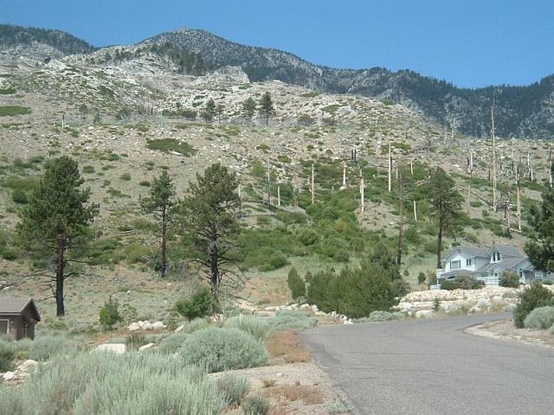
Photo Point 2. North Foothill Road Corridor. 4312103N, 253453E, 250°W. The Autumn Hills burn consists primarily of rabbitbrush, sagebrush, and bitterbrush. The fuel load was estimated at one to two tons per acre and was considered a moderate fuel hazard.
Photo Point 3. North Foothill Road Corridor. 4319528N, 0254299E, 265°W. In the unburned areas north of the 1984 fire, the vegetative fuels consist of high density big sagebrush and rabbitbrush with a cheatgrass understory. Fuel loads were estimated to range between four and six tons per acre and the vegetation was considered a high fuel hazard.