![]()
![]()
15.0 Golden Valley
15.1 Risk and Hazard Assessment
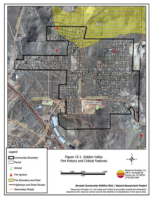
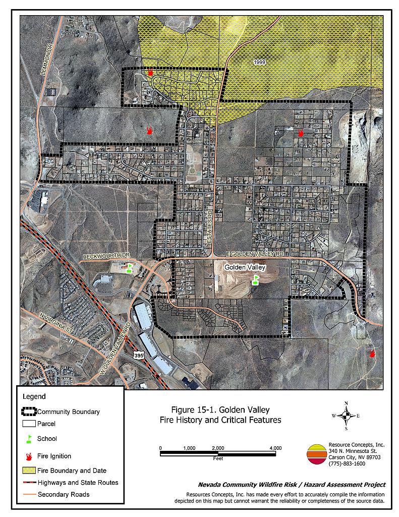
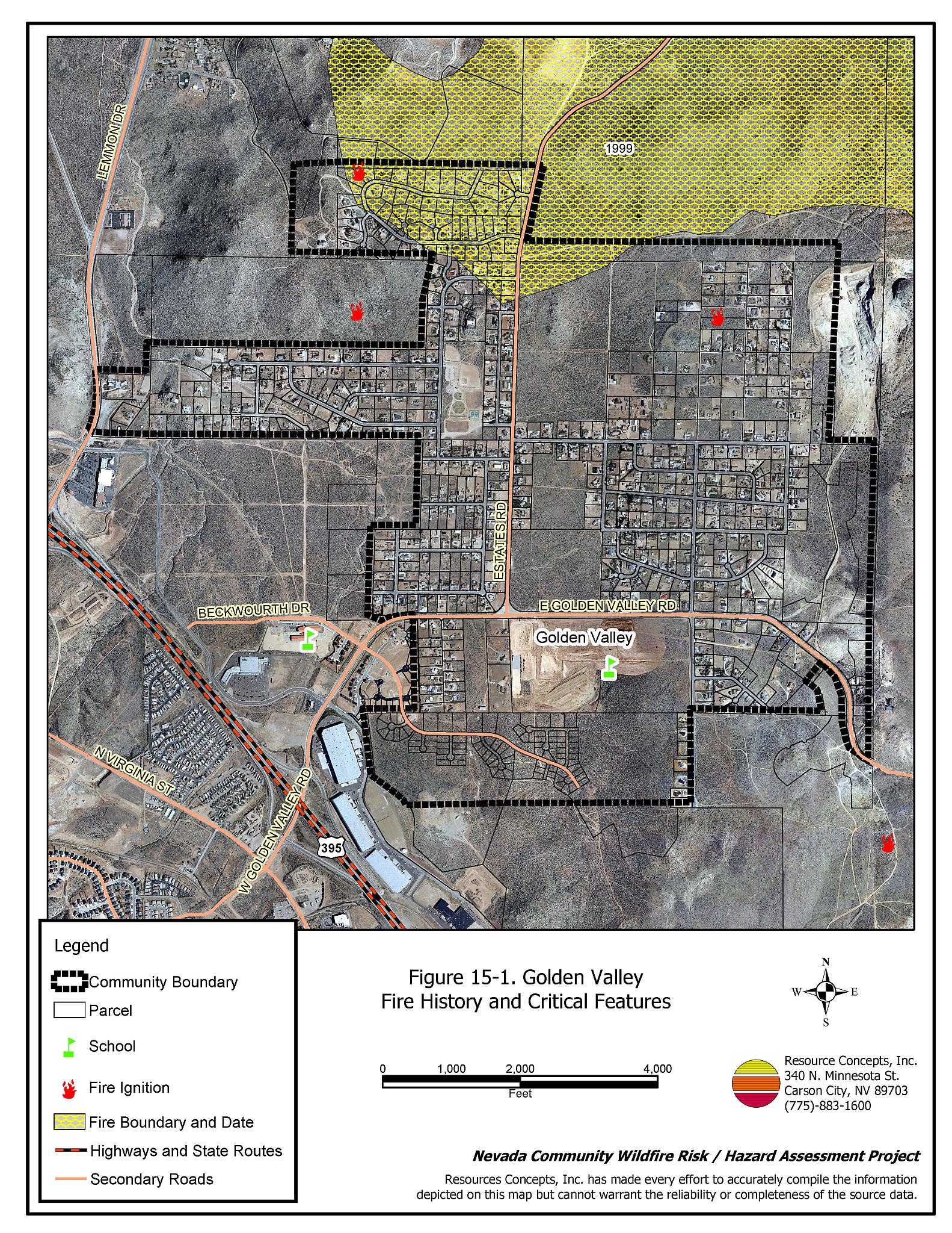
The Golden Valley community is located north of Reno, north of US Highway 395, between Lemmon Valley and Sun Valley. Foothills surround the north, east, and south sides of the community. The community boundary is shown in Figure 15-1. The community hazard assessment resulted in classifying Golden Valley in the Moderate Hazard Category (58 points). A summary of factors that contributed to the hazard rating is included in Table 15-3. Primary factors that determined the hazard rating in Golden Valley include the high number of homes with flammable roofing materials and limited fire suppression resources.
15.1.1 Community Design
The wildland-urban interface area in Golden Valley is described as an intermix condition. There is no clear line of demarcation between wildland fuels and the residential structures in the community. Most of the residences are located on lots between one and ten acres in size.
- Access: Golden Valley Road is the primary road providing access to the community. The community can also be accessed by Lemmon Drive. These roads are greater than 24 feet wide and provide adequate space for two-way vehicular travel and for fire suppression equipment to maneuver.
- Signage: All street signs are easily visible and 93 percent of residential addresses are easily visible from the road. Clear and visible street signs and residential addresses are important in locating homes during low visibility conditions that occur during a wildfire.
- Utilities: All utilities are above ground. Power lines have not been properly maintained in all cases. Proper maintenance minimizes the possibility that arcing may start fires in nearby vegetation.
15.1.2 Construction Materials
A great majority of homes in the interface are built with non-combustible or ignition resistant siding such as medium density fiberboard, stucco, or brick. Sixty-nine percent of the homes have roofs of non-combustible material such as tile, metal, or composition. Approximately thirteen percent of the homes observed have unenclosed balconies, porches, decks, or other architectural features. Unenclosed features on homes can create drafty areas where sparks and embers can be trapped, smolder, ignite, and rapidly spread fire to the house.
15.1.3 Defensible Space
Approximately 86 percent of the homes surveyed in the Golden Valley community have landscaping that meets defensible space guidelines to protect the home from damage or loss during a wildfire.
15.1.4 Suppression Capabilities
Wildfire Protection Resources
There is no fire station within the Golden Valley community. The closest fire resources are Reno Fire Department career staffed stations located in Sun Valley and Stead. The standard Reno Fire Department dispatch for a wildland fire is shown in Table 15-1. Additional resources are available upon request from local, state, and federal agencies through mutual aid agreements as described in Section 4.1.1.
| Type of Resource | Amount of Equipment | Cooperating Partner (Resource Location) |
|---|---|---|
| Engine Type 3 Engine Type 1 Water Tender Battalion Chief Safety Officer |
3 1 1 1 1 |
Reno Fire Department (Closest available career and volunteer resources) |
| Source: Roy Slater and Marty Scheuerman Reno FD | ||
Detection and Communication
Fires are reported in Washoe County through the 911 system, which connects the call with the Washoe County 911 Center. Washoe County 911 notifies the Sierra Front Interagency Dispatch Center of wildland fires. The Sierra Front Interagency Dispatch Center notifies the Volunteer Fire Departments, the Nevada Division of Forestry, the Bureau of Land Management, and the US Forest Service of fires through the use of pagers and radios.
Communication frequencies are currently compatible between agencies. When the federal agencies go to narrow band digital radios, the volunteers will no longer be able to communicate with the Bureau of Land Management and US Forest Service.
Water Sources and Infrastructure
Golden Valley has fire hydrants with minimum flow capacities of 1,000 gallons per minute within 1,000 feet of structures in most areas of the community. Water supplies for areas without hydrants are available within a twenty minute round trip.
Community Preparedness
Golden Valley is included in the Washoe County All-Risk Emergency Plan.
15.1.5 Factors Affecting Fire Behavior
The terrain in the wildland-urban interface areas of the community is generally flat. The surrounding foothills have slopes of eight to twenty percent. West and south facing aspects are the most common throughout the valley. The prevailing wind direction is from the south and southwest. High wind speeds are common.
The vegetative fuels in the Golden Valley community primarily consist of Wyoming big sagebrush, rabbitbrush, Mormon tea, and greasewood in the shrub layer with cheatgrass and bottlebrush squirreltail as the dominant ground fuels. The fuel loading was estimated to range between one and three tons per acre and was considered a moderate fuel hazard.
15.1.6 Fire Behavior Worst-Case Scenario
The worst-case scenario for Golden Valley would be a fire starting in the brush within the community on a high hazard day, with strong winds greater than twenty miles per hour from the south-southwest pushing the fire upslope to the northeast. A wind-driven fire in this location would quickly threaten many homes.
15.1.7 Ignition Risk Assessment
Golden Valley has a high ignition risk rating. There is an extensive history of wildfire and fire ignitions within and surrounding the community. High ignition rates are due to the frequency of lightning storms during the summer and moderate to high vehicular traffic.
15.2 Risk and Hazard Reduction Recommendations
The responsibility to keep a community fire safe falls not only on the local fire protection district but also on the residents of the community, businesses, and local governments.
15.2.1 Defensible Space Treatments
Defensible space treatments are an essential first line of defense for residential structures. The goal of the treatments is to significantly reduce or remove flammable vegetation within a prescribed distance from structures. (Refer to Appendix E for the recommended defensible space area). Defensible space reduces the fire intensity and improves firefighter and homeowner chances for successfully defending a structure against oncoming wildfire.
Property Owner Recommendations
- Remove, reduce, and replace vegetation to create defensible space around homes according to the guidelines in Appendix E. This area should be kept:
- Lean: There are only small amount of flammable vegetation.
- Clean: There is no accumulation of dead vegetation or other flammable debris.
- Green: Existing plants are healthy and green during the fire season.
- Store firewood a minimum distance of thirty feet from structures.
- Clear all dead plant material and combustible materials a minimum of five feet from the exterior of all structures.
- Mow or remove brush growing against fences in the community. The minimum distance for clearance should be ten feet in grass and 25 feet in brush.
- Enclose areas under wood decks and porches when possible or maintain these areas to be free of weeds and other flammable debris. Box in eves and cover ventilation openings with very fine metal wire mesh to prevent embers from entering the attic and crawl spaces.
- Clear all vegetation and combustible materials around propane tanks for a minimum of ten feet.
- Clear weeds and brush to a width of ten feet along both sides of the driveways.
- Maintain a minimum clearance of thirty feet from the crown of trees that remain within the defensible space zone. Keep this area free of smaller trees, shrubs, and other ladder fuels.
- Trim and remove tree branches a minimum of four feet from the ground to reduce ladder fuels on all deciduous and coniferous trees within the defensible space zone. Prune all dead and diseased branches.
- Prune all tree branches to a minimum distance of fifteen feet from buildings, paying special attention around chimneys.
- Mow grass within the defensible space zone to maintain a maximum height of four inches.
- Thin sagebrush and other shrubs to a spacing between shrubs that is equal to twice the shrub height.
- Immediately dispose of cleared vegetation when implementing defensible space treatments. This material dries quickly and poses a fire hazard if left on site.
- Where possible, irrigate all trees and large shrubs that remain in close proximity to structures to increase their fire resiliency. This is especially important during drought conditions.
- Install spark arrestors on chimneys.
- Removed or board up abandoned trailers and structures to prevent sparks entering and igniting the structure.
- Maintain the defensible space as needed.
Reno Fire Department Recommendation
- Conduct courtesy inspections of home defensible space measures and assist with defensible space treatments.
15.2.2 Fuels Reduction Treatments
Fuel reduction treatments are applied on a larger scale than defensible space treatments. Permanently changing the fuel characteristics over large blocks of land to one of a lower volume and altered distribution reduces the risk of a catastrophic wildfire in the treated area. Reducing vegetation along roadways and driveways could reduce the likelihood of blocking access and escape routes, help contain the fire perimeter, and improve firefighter access and safety for protecting homes.
Utility Company Recommendation
- Reduce and remove vegetation to maintain clearance around power lines. Clear vegetation within fifteen feet of utility poles in brush areas of the community. Remove all tree limbs from power lines.
Washoe County Recommendations
- Reduce vegetation and maintain roads by mowing all vegetation to a height of no more than four inches for a distance of ten feet from the edge of the pavement on both sides of the road. Remove biomass and dispose at an appropriate site. Reseed treated areas with fire resistant species such as recommended in Appendix E to minimize cheatgrass and noxious weed invasion.
Reno Fire Department Recommendation
- Develop and promote a program for cleaning weeds and debris from around structures and fences in the community and for biomass disposal. Continue to enforce the permit process for open burning.
15.2.3 Community Coordination
Washoe County Recommendations
- Continue to require all future development in the County to meet the National Fire Codes with regard to community design, building construction and spacing, road construction and design, water supply, and emergency access. Refer to Appendix F for an example of fire safe recommendations for planning new developments.
- Develop and enforce ordinances regarding fuel reduction and defensible space requirements for wildland-urban interface areas. Require defensible space implementation and maintenance on all developed lots and fuel reduction on all vacant lots within the interface area. Require approval by the appropriate fire agency of completed fuel reduction treatments prior to issuance of building permits for new wildland-urban interface developments.
- Facilitate coordinated and collaborative efforts at the County and State levels for consistency in fire safe community planning and enforcement of fire safe ordinances in a unified manner.
15.2.4 Public Education
A public education program that explains fire safe measures in clear and emphatic terms will have an impact on residents of the wildland-urban interface. Informed community members will be more inclined to make efforts to effectively reduce wildfire hazards around their homes and neighborhoods.
Reno Fire Department Recommendation
- Distribute copies of the publication “Living with Fire” to all property owners. This publication is free of charge. Copies can be requested from the University of Nevada Cooperative Extension.
15.3 Summary of Recommendations
| Involved Party | Recommended Treatment | Recommendation Description |
|---|---|---|
| Property Owners |
Defensible Space Treatments | Remove, reduce, and replace vegetation around homes according to the defensible space guidelines in Appendix E. |
| Utility Company | Fuels Reduction | Remove trees and thin shrubs beneath power lines and utility poles. Maintain fifteen feet of clearance around utility poles. |
| Washoe County | Fuel Reduction | Reduce vegetation and maintain a minimum of ten feet of clearance from the edge of all roadways within the community. |
| Community Coordination | Continue to require all future development in the County to meet the national fire codes with regard to community design, building construction and spacing, road construction, water supply, and emergency access. Develop and/or enforce county laws, regulations, and ordinances for defensible space and fuels reduction that include absentee homeowners, vacant lots, and new subdivisions. Facilitate coordinated and collaborative efforts at the County and State levels for consistency in fire safe community planning and enforcement of fire safe ordinances in a unified manner. |
|
| Reno Fire Department | Defensible Space Treatments | Conduct courtesy inspections of defensible space condition and assist with implementation of defensible space treatments on private property. |
| Public Education | Distribute copies of the publication “Living with Fire” to all property owners. | |
| Fuels Reduction | Develop and promote regular brush clearance and biomass disposal, and continue to enforce the open burn permit programs. |
Table 15-3Golden Valley Wildfire Hazard Rating Summary |
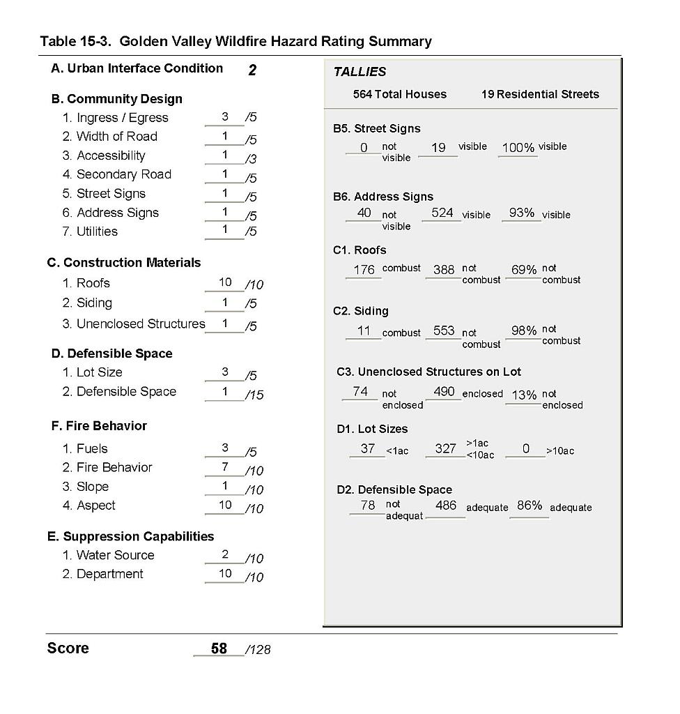 |
Figure 15-1Golden Valley Fire History and Critical Features |
 |