![]()
![]()
6.0 Lockwood
6.1 Risk and Hazard Assessment
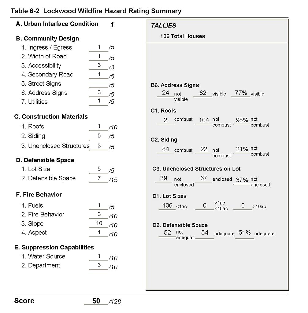
Lockwood is located on a terrace bound on the north by the Truckee River and on the west by Long Valley Creek. The town is set against the steep north facing slopes of the Virginia Range. The risk assessment resulted in classifying Lockwood in the Moderate Hazard category (50 points). The moderate hazard rating is primarily attributed to a large percentage of homes built with combustible building material, a high density of homes on small lots, inadequate defensible space around a substantial proportion of structures, steep gradient access roads, inadequate address signage, and steep terrain in close proximity to the community that would intensify fire behavior. A summary of the factors that contributed to the hazard rating is included in Table 6-2.
6.1.1 Community Design
Lockwood has a classic wildland-urban interface condition with a clear line of demarcation between structures and wildland fuels. Wildland vegetation typically does not continue into developed areas. All of the 106 lots observed were less than one acre in size.
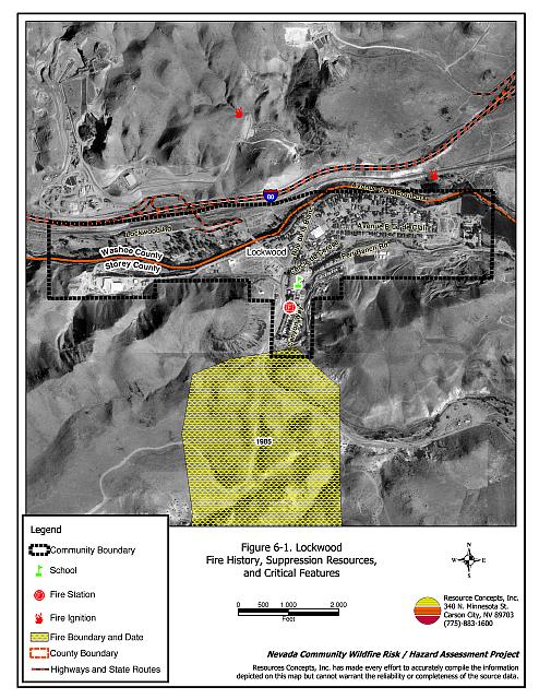
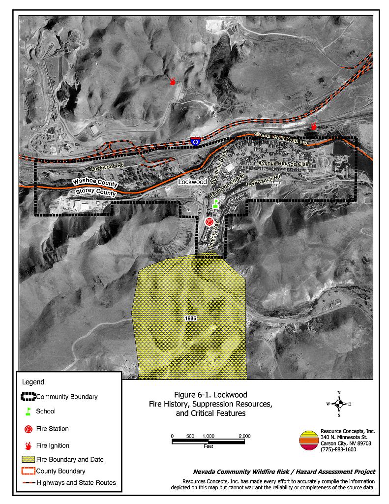
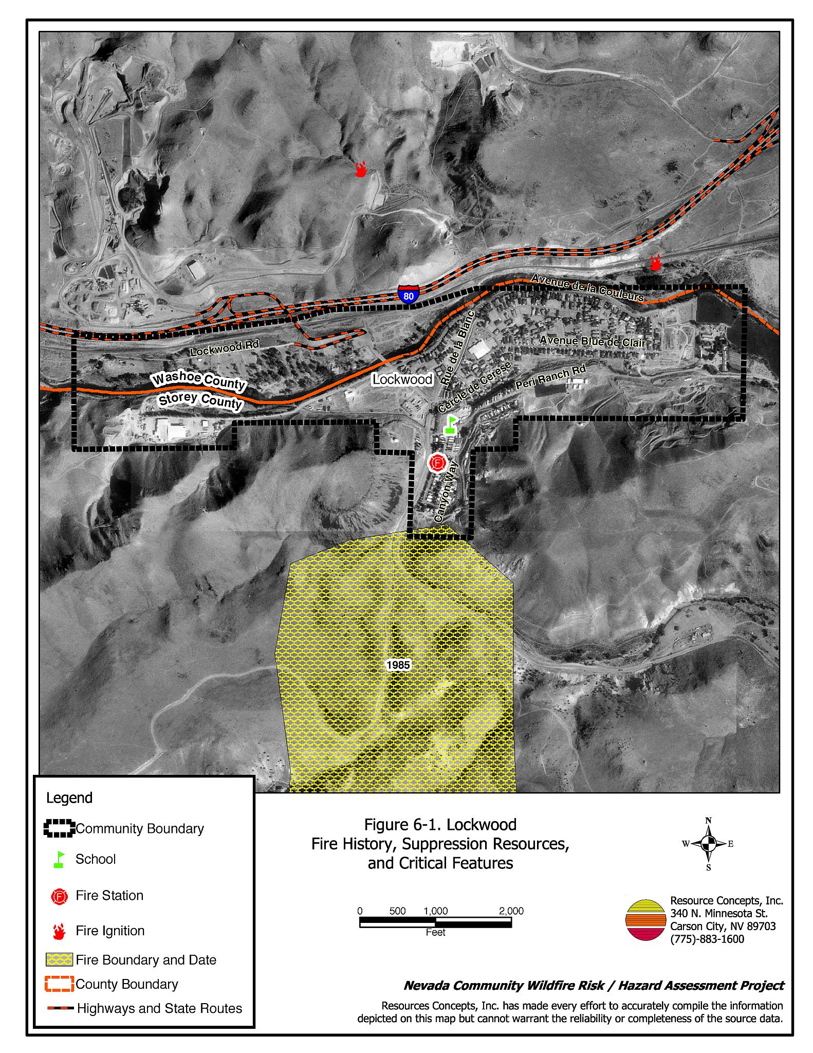
- Roads: Interstate 80, exit number 22 provides the primary access for the community. This frontage road is paved, at least 24 feet wide, and has adequate turnaround space for fire suppression equipment. This road crosses over the Truckee River on a bridge that supports frequent heavy truck traffic. Several of the secondary roads have dead ends.
- Signage: Street signs were present on all but four streets in Lockwood. Residential addresses were visible on approximately 77 percent of the houses surveyed.
- Utilities: Electric utilities are above ground and are well maintained.
6.1.2 Construction Materials
Twenty-one percent of the homes assessed in the interface were built with fire resistant siding materials, and 98 percent of the homes assessed had fire resistant roofing materials such as composition roofing, metal, or tile. Approximately one-third of the homes observed had unenclosed balconies, porches, decks, or other architectural features that create drafts and provide areas where sparks and embers can accumulate, smolder, ignite, and rapidly spreading fire to the home.
6.1.3 Defensible Space
The defensible space requirement is based on vegetation and slope as illustrated in Appendix E. In general, the homes in the interface area are adjacent to sagebrush and bitterbrush fuels, downslope of steep terrain greater than thirty percent, on the west side of the community. The appropriate width of the defensible space zone can be determined from the guidelines in Appendix E. Approximately one half of the homes had landscaping that would meet the requirement for defensible space to protect the home from damage or loss during a wildfire.
6.1.4 Suppression Capabilities
Wildfire Protection Resources
Storey County Fire Station #4 in Lockwood provides first alarm response to the community. At the time of publication, this station was staffed by a combination of six career and twelve volunteer positions (G. Hames, pers. comm.). Resource availability and mutual aid agreements with Storey County Fire Protection District are described in Section 4.1.1.
Water Sources and Infrastructure
Lockwood has a variety of water resources for fire suppression including
- 500 gpm water hydrants within 500 feet of structures, and
- Two water tanks, one 2-million gallon capacity and one 1-million gallon capacity.
The water systems are powered by both gravity and pumps that are backed up with an emergency diesel generator. The fire main flow is 4,000 gpm and the residential flow is 2,000 gpm. Water systems meet or exceed the current codes.
6.1.5 Factors Affecting Fire Behavior
The fuel hazard in the interface area around Lockwood was considered low. Fuels in the area are mostly low-density sagebrush, typically one to two feet in height. Fuel loading was estimated to be less than one ton per acre. Fuels have been reduced in some places due to past fires. Slopes in the area reach eighty percent; however, the north aspect and light fuel loading reduce the risk to the community. Long Valley runs south to north and may create strong winds through the community. The predominant wind directions in the area are from the south and from the west.
6.1.6 Fire Behavior Worst-case Scenario
The worst-case wildfire scenario would be a fire that starts mid-afternoon during the summer months. Down-canyon winds from the south would drive the fire into the light sagebrush on the south side of Lockwood. An additional concern would be a fire burning downslope from the west behind the pellet factory. A fire approaching the factory yard could cause firebrands to ignite the stockpiled inventory of pellets in the yard and intensify fire behavior.
Any wildfire incident could be worsened if the one bridge that accesses Interstate 80 from the community were to become impassable, for example due to a car accident. Emergency vehicles would not be able to access the community and residents would not be able to evacuate.
6.1.7 Ignition Risk Assessment
Lockwood was rated with a low ignition risk. Ignition history for the Lockwood area is concentrated along the I-80 corridor, with dispersed ignitions to the north of Interstate 80 as shown in Figure 6-1. The Truckee River effectively isolates the community from ignition risks associated with traffic. The Lockwood landfill presents a minor risk for ignition of waste material.
6.2 Risk and Hazard Reduction Recommendations and Responsibilities
The risk and hazard reduction recommendations for Lockwood prioritize defensible space treatments within the community. Community coordination and public education are important recommendations that work in conjunction with each other to facilitate implementation and long-term maintenance of defensible space and fire safety awareness. Roles and responsibilities are summarized in Table 6-1.
6.2.1 Defensible Space Treatments
Vegetation density, type of fuel, and slope gradient around a home affect the potential fire exposure levels to the home. The goals of defensible space are to reduce the risk of property loss from wildfire by eliminating flammable vegetation near the home, thereby lowering the potential to burn and providing firefighters a safer working area from which to defend the home or outbuilding during a wildland fire. Guidelines for improving defensible space around residences and structures in the community are given below and are described in detail in Appendix E.
Property Owner Responsibilities
- Remove, reduce, and replace vegetation to create defensible space around homes according to the guidelines in Appendix E. This area should be kept:
- Lean: There are only small amounts of flammable vegetation,
- Clean: There is no accumulation of dead vegetation or other flammable debris, and
- Green: Existing plants are healthy and green during the fire season.
- Shrubs should be thinned to a spacing equal to twice their height.
- Clear weeds and brush for a width of ten feet along both sides of the driveway.
- Clear all vegetation and combustible materials around propane tanks for a minimum distance of ten feet.
- Prune trees so that branches are at least fifteen feet away from chimneys and structures. Maintain a minimum clearance distance of thirty feet from the crown of trees to structures and other tree crowns that remain within the defensible space zone. Prune and remove all dead and diseased branches from trees.
- Mow or removebrush growing within ten feet of fences in the community.
- Immediatelydispose of cleared vegetation when implementing defensible space treatments. This material dries quickly and poses a fire hazard if left on site.
- Store firewood a minimum distance of thirty feet from structures
- Maintain areas under wood decks and porches free of weeds and other flammable debris. Install screens around unenclosed overhangs where possible.
- If possible, irrigate all trees and large shrubs in close proximity to structures to increase their fire resiliency. This is especially important during drought conditions.
- Maintain thedefensiblespace annually.
6.2.2 Community Coordination
Many of the most effective activities aimed at reducing the threat of wildfire for the Lockwood Community require that individual property owners coordinate with each other and with local fire authorities. Defensible space, for example, is more effective in small communities when applied uniformly throughout entire neighborhoods. Public education and awareness, neighbors helping neighbors, and proactive individuals setting examples for others to follow are just some of the approaches that will be necessary to meet the fire safe goals in the community.
Property Owner Responsibility
- Assure that address signs are visible from the road. Address characters should be at least four inches high, reflective, and composed of non-flammable material. Improving visibility of addresses will make it easier for those unfamiliar with the area to navigate under smoky conditions during a wildland fire.
Storey County Commissioner Responsibilities
- Require all future development in the County to meet the national fire codes with regard to community design aspects, building construction and spacing; road construction and design, water supply, and emergency access. Refer to Appendix F for an example of fire safe recommendations for planning new developments.
6.2.3 Public Education
Public education about fire safety is critical. A program that explains fire safe measures in clear and emphatic terms will have an impact on residents in the wildland-urban interface. Informed community members will be more inclined to make efforts to effectively reducing the wildfire hazards to their homes and neighborhoods.
Priority recommendations for Lockwood are summarized in Table 6-1.
6.3 Summary of Recommendations
| Responsible Party |
Recommended Treatment | Recommendation Description |
|---|---|---|
| Property Owners | Defensible Space | Remove, reduce, and replace vegetation around home according to the defensible space guidelines in Appendix E. |
| Community Coordination | Participate in public education opportunities and become knowledgeable of emergency evacuation procedures. Organize community clean-up events to remove weeds and debris in town. Expand the use of address and street signage where needed. |
|
| Storey County Fire Department | Public Education | Enforce or develop county laws, regulations, and ordinances for defensible space and fuel reduction that include responsibilities for absentee homeowners, vacant lots, and new subdivisions. Distribute copies of the publication “Living with Fire” to all property owners. Contact the Nevada Cooperative Extension and BLM for assistance with public education. |
| Storey County Commissioners | Community Coordination | Require all future development in the County meet the national fire codes with regard to community design aspects; building construction and spacing; road construction and design; water supply; and emergency access. |
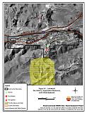
Figure 6-1Lockwood Fire History, Suppression Resources, and Critical Features |
 |
Table 6-2Lockwood Wildfire Hazard Rating Summary |
 |