![]()
![]()
9.0 Mill City
9.1 Risk and Hazard Assessment
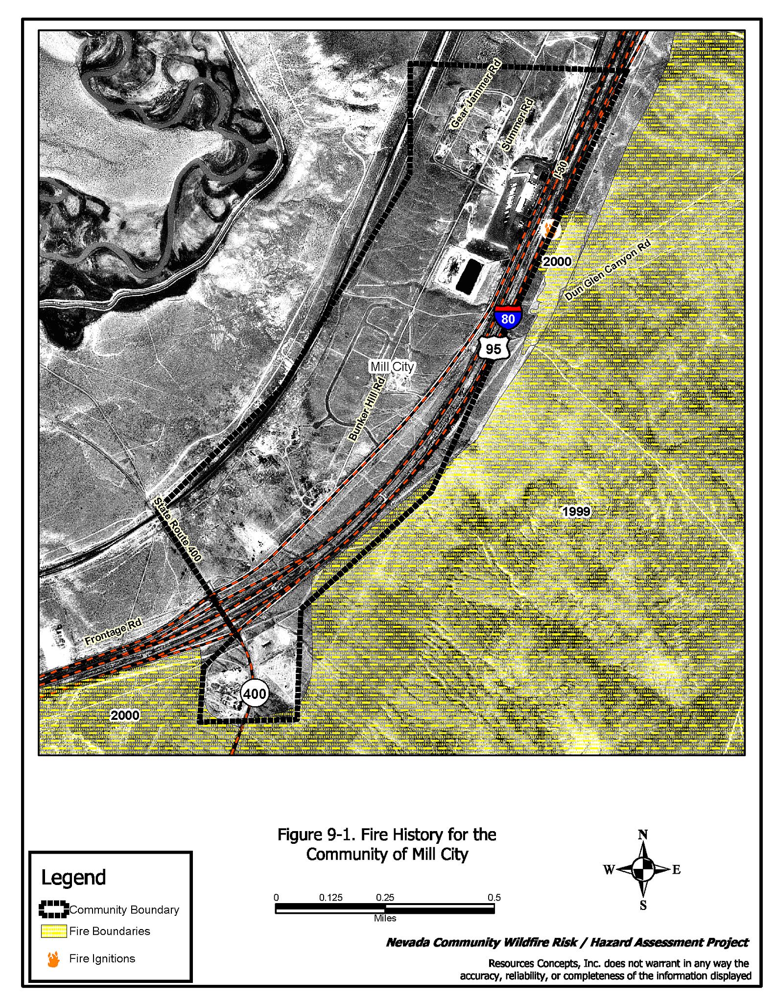
Mill City is located in the northern portion of Pershing County adjacent to Interstate 80 (see Figure 9-1). Mill City is a community of about 18 homes and a large commercial truck stop. The risk and hazard assessment resulted in classifying Mill City in the Moderate Hazard category (56 points). The primary risk factors for Mill City are lack of a community water system and absence of a local fire department. The community assessment summary sheet is provided at the end of this section.
9.1.1 Community Design
The interface condition surrounding Mill City is classified as an intermix condition. Structures are scattered throughout the wildland area with no clear line of demarcation between wildland fuels along roads and back property fences and structures. Lot sizes are typically less than one acre in size. Structure spacing varies, as some buildings are very close together while other structures are surrounded by sizeable expanses of vacant land.
- Roads: Interstate 80, a paved four-lane highway with a road width in excess of 24 feet, is the primary transportation route to Mill City. State Route 400 also crosses through the community and connects with Interstate 80. State Route 400 is also paved and at least 24 feet in width. Both roads have a gradient less than five percent. A paved frontage separates Mill City from the Interstate, and long, unpaved driveways intersect the frontage road.
- Signage: All of the streets have easily visible street signs. Residential addresses were visible on less than one quarter of the homes. Clear and visible residential addresses are important to aid firefighting personnel in locating homes during low visibility conditions that may occur during a wildland fire.
- Utilities: Electric utilities are all above ground. There is minimal vegetation in the power line corridors, minimizing the ignition risk from sparking power lines during windstorms.
9.1.2 Construction Materials
Most of the homes in the interface are built with non-combustible siding materials. The roofs of all of the homes are made with fire-resistant composite or metal roofing materials. Approximately two-thirds of the homes observed had unenclosed balconies, porches, decks or other architectural features that could create drafts and provide areas where sparks and embers can smolder and rapidly spread fire if the home ignites.
9.1.3 Defensible Space
Most of the homes have landscaping that would meet the requirement for defensible space to help protect the home from damage or loss during a wildfire.
9.1.4 Suppression Capabilities
Wildfire Protection Resources
There is no organized volunteer or paid fire department in Mill City. Additional resources from the BLM and the Nevada Division of Forestry conservation camp, both located in Winnemucca, can be requested in the event of a wildfire. Table 9-1 lists the types of wildfire resources, cooperating partners and equipment available to Mill City to respond to a reported wildland fire.
| Response Time | Type of Equipment | Amount of Equipment | Cooperating Partner (Resource Location) |
|---|---|---|---|
| 10- 20 minutes | Type II Engine Water Tender |
1 1 |
Imlay VFD (Imlay) |
| 30 minutes | Engine | 1 | Rye Patch VFD (Rye Patch) |
| 45 minutes | Brush Truck Pumper Water Tender Command Vehicle |
1 1 1 1 |
Lovelock VFD (Lovelock) |
| Source: Dora Wren, email comm., May 19, 2004. | |||
The initial response to a wildland fire by volunteer-staffed fire departments will vary depending on day of week and time of day that the fire is reported. Some volunteer fire department members may be unable to respond immediately to fire calls during normal working hours.
Water Sources and Infrastructure
There is no community water system in Mill City.
Fire Protection Personnel Qualifications
Not applicable.
Work Load
Not applicable.
Financial Support
Not applicable.
Community Preparedness
Pershing County has an active Local Emergency Planning Committee and has adopted an all-risk, multi-agency emergency plan. The plan is periodically updated and was last revised in 2003.
9.1.5 Factors Affecting Fire Behavior
The vegetative fuel density in the Mill City interface area on the east side of the Interstate varies from light to medium due to past fires. Fuels in the community consist primarily of cheatgrass, perennial grasses, shadscale, and rabbitbrush. Fuel loading is heavier on the west side of Interstate 80. The terrain is fairly flat (eight percent or less slope). The fire behavior potential in Mill City is considered low due to the sparse vegetation and flat terrain. The fuel load was estimated at one-half ton per acre. The predominant wind is from the south/southwest in the late afternoon.
9.1.6 Fire Behavior Worst-Case Scenario
The worst-case scenario for Mill City would likely be a wind driven wildland fire threatening the south side of town in the mid-afternoon on a high hazard day. Because of the low, sparse brush, the threat is considered to be low. The situation would be worsened if mutual aid resources were unavailable due to fire activity in other areas.
9.1.7 Risk Assessment
Mill City is classified as having a high ignition risk and a low fire behavior hazard due to sparse, low brush in and around the community. The fact that the community has no local fire suppression capabilities implies that an ignition could spread before fire suppression resources arrive.
The following factors pose the greatest ignition hazards that could start a wildland fire:
- Lightning
- Railroad
- Powerline Corridors
9.2 Risk and Hazard Reduction Recommendations, Roles, and Responsibilities
Mill City is a small community with no local fire suppression resources. In previous years, wildland fires have burned to the edges of the community. NDOT implemented a greenstrip risk reduction project in Mill City after these large fires along the highway. The project was not successful, as bur buttercup (Ceratocephala testiculatus), an annual forb has become the dominant species on these sites. The following Risk Reduction Recommendations for Mill City focus on defensible space and homeowner responsibilities. These recommendations are detailed below and summarized in Table 9-2.
9.2.1 Defensible Space Treatments
General guidelines for improving defensible space around residences and other structures in the community are described below.
Property Owner Responsibilities
- Remove, reduce, and replace vegetation around homes according to the guidelines in Appendix D. This area should be kept:
- Lean: There are only small amounts of flammable vegetation,
- Clean: There is no accumulation of dead vegetation or other flammable debris,
- Green: Existing plants are healthy and green during the fire season.
- Maintain this defensible space as needed to keep the space lean, clean, and green.
- Where cheatgrass has become dominant within the defensible space area it should be mowed prior to seed set or treated with an application of pre-emergent herbicide. Mowing may need to be repeated the following year to ensure that the seed bank of unwanted grasses has been depleted. Refer to Appendix I for approved seed mixes and planting guidelines than can be used in conjunction with removal of this annual grass.
- Remove debris and woodpiles from within the defensible space area.
- Spark arrestors should be installed on chimneys.
- Abandoned vehicles, trailers, and structures should be removed or boarded up and the fuels around them removed.
9.2.2 Fuel Reduction Treatments
Reduction of fuels in strategic areas or replacement of those fuels with less flammable fuels will help protect structures and resources. Following is a recommendation to provide added protection to structures in the community and also allow safe routes for fire suppression equipment in the event of a wildland fire.
Property Owner Responsibilities
- Reduce fuels in an area at least 10 feet wide along both sides of private driveways. Flammable fuels such as annual grasses should be replaced with fire-resistant species such as crested wheatgrass or an approved pre-suppression seed mix. Refer to Appendix I for approved seed mixes, planning guidelines and seed sources.
Nevada Department of Transportation Responsibilities
- Mow vegetation along road shoulders a minimum distance of 10 feet from the edge of the frontage road. Excess biomass should be removed to a suitable disposal site.
9.2.3 Community Coordination
Coordination among local, state and federal fire suppression agencies is important in the day-to-day fire prevention activities and becomes critical in the event of a wildland fire. During a fire event, firefighters from other communities and states may be dispatched to work in unfamiliar areas. This coordination becomes more important in communities such as Mill City where there is no local fire suppression agency. The following recommendations related to Community Coordination should be implemented in Mill City.
Property Owner Responsibilities
- Form a local chapter of the Nevada Fire Safe Council. The Nevada Fire Safe Council has the purpose of working on solutions to reduce the loss of lives and property from the treat of fire in Nevada’s communities. Through the establishment of a local Chapter, local communities will have access to the information network that receives notifications of programs and funding opportunities for fire mitigation projects such as those listed in this report and will become part of a large network for sharing information. The Nevada Fire Safe Council will accept and manage grants and contracts on the Chapter’s behalf through its non-profit status. The Nevada Fire Safe Council will provide assistance and support to communities to complete fire safe plans, set priorities, educate and train community members and promote success stories of its members. To form a local Chapter or for more information, contact the Nevada Fire Safe Council, PO Box 2724, Carson City, NV 89702, telephone (775) 884-4455.
Pershing County Responsibilities
- Allow burning only under a permit process or on designated community burn days. See Appendix G for a sample burn permit.
- Install either a 5,000-gallon (minimum) water dip tank or an equivalent size pond near the community to provide a water source for initial attack and helicopter water bucket use.
9.2.4 Public Education
Public education regarding how to become more fire safe is critical in communities that have no local fire suppression resources such as Mill City.
Pershing County Responsibilities
- Distribute copies of the publication “Living with Fire” to all property owners. This publication is free of charge. Copies can be requested from the University of Nevada Cooperative Extension, (775) 784-4848.
9.3 Summary of Recommendations
| Responsible Party |
recommendation Description |
|---|---|
| Property Owners | Remove, reduce, and replace vegetation around homes according to the defensible space guidelines in Appendix D. Maintain defensible space. Remove cheatgrass within defensible space. Remove debris and wood piles. Install spark arrestors on chimneys. Remove or clean up abandoned vehicles, trailers, and structures. Reduce fuels at least 10 feet along both sides of private driveways. Form a local chapter of the Nevada Fire Safe Council. |
| Pershing County | Mow vegetation along frontage road a minimum distance of 10 feet on both sides of road. Allow burning only under a permit process or on set designated community burn days. Install a minimum 5,000-gallon water tank for use by fire suppression agencies. Distribute copies of the publication “Living with Fire” to all property owners. |
| NDOT | Mow vegetation along road shoulders a minimum distance of 10 feet from the edge of the frontage road. |
Table 9-3Mill City Wildfire Risk/Hazard Assessment Summary Sheet |
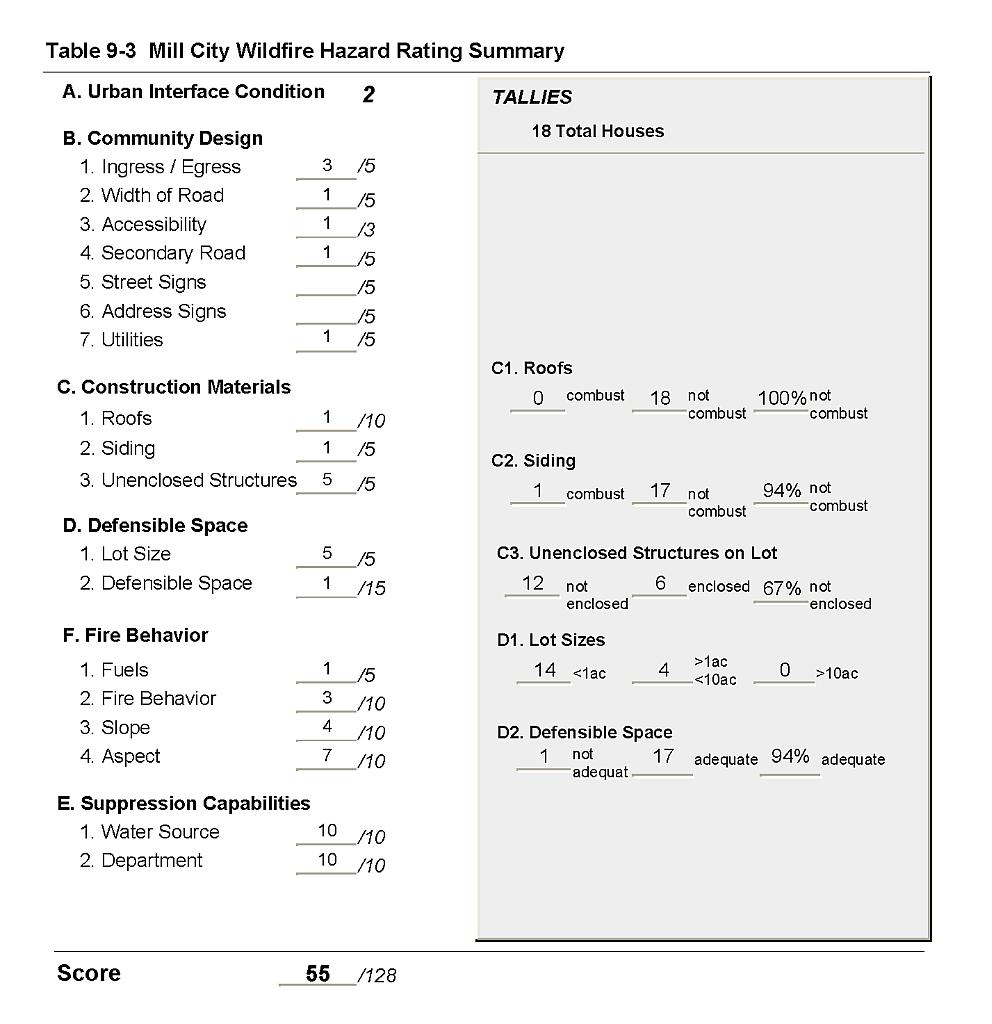 |
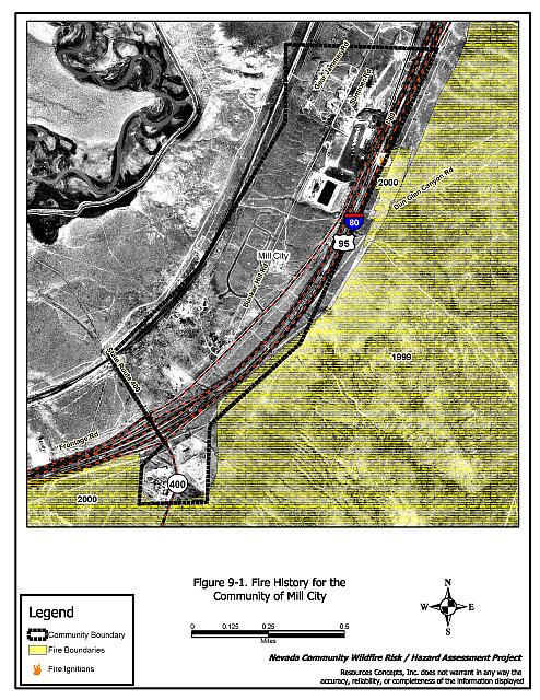
Figure 9-1Fire History for the Community of Mill City |
 |