![]()
![]()
7.0 Imlay
7.1 Risk and Hazard Assessment
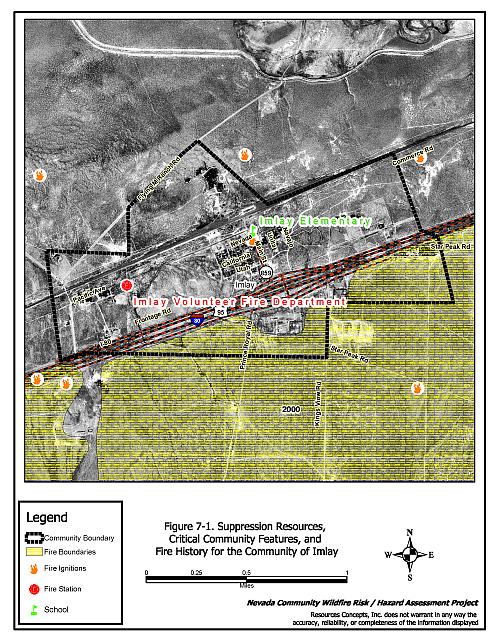
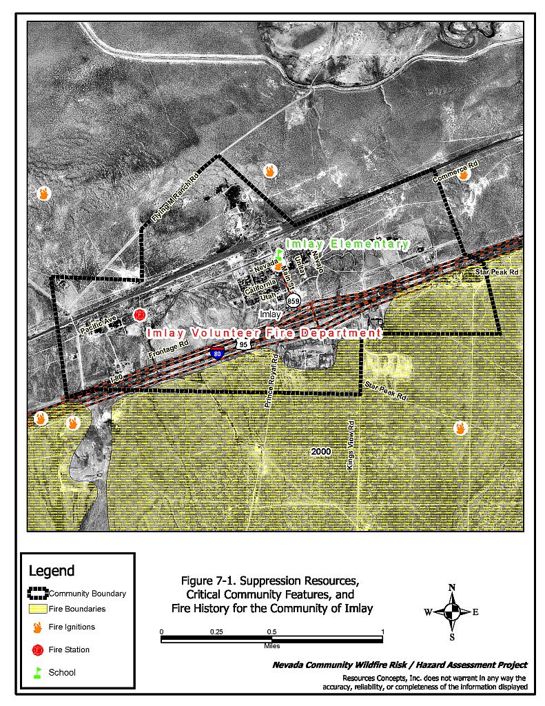
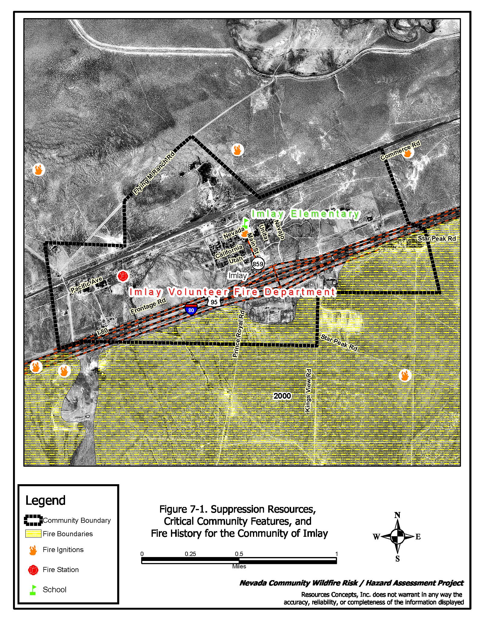
Imlay is located in central Pershing County approximately 40 miles northeast of Lovelock on Interstate 80 (see Figure 7-1). There are 238 residents in Imlay (Nevada State Demographer 2003). The results of the risk/hazard assessment classify Imlay in the Moderate Hazard category (51 points). The primary risk factors for Imlay were limited road signage and address visibility on residences. The community assessment summary sheets are included at the end of this section.
7.1.1 Community Design
Imlay is classified as having a classic interface condition. There is a clear line of demarcation between the structures and the wildland area. Most lots are less than one acre in size.
- Roads: Interstate 80, a paved, four-lane divided highway, is the major transportation route through Imlay.
One paved secondary road passes through the community. All other secondary roads are graded dirt roads. All secondary roads provide adequate room for fire suppression equipment to maneuver.
- Signage: Street signs are visible on about 20 percent of the roads in the community. Residential addresses were visible on about half of the homes in the community. Clear and visible residential addresses are important to aid fire-fighting personnel in locating homes during low visibility conditions that may be present during a wildland fire.
- Utilities: Utilities are all above ground. Power lines have been properly maintained to minimize the possibility of sparking power lines igniting fires in nearby vegetation during windstorms.
7.1.2 Construction Materials
Approximately two-thirds of the homes in the interface are built with non-combustible siding materials. Almost all of the homes have fire resistant (composite or metal) roof materials.
Over half of the homes in the community have unenclosed balconies, porches, decks or other architectural features that create drafts and provide areas where sparks and embers can smolder and rapidly spread fire if the home ignites.
7.1.3 Defensible Space
A majority of the homes have landscaping that would meet the landscaping requirement for defensible space to minimize damage or protect from loss during a wildfire. There are some exceptions where residences have excess vegetation, stacked wood, or debris in close proximity to the structure.
7.1.4 Suppression Capabilities
Wildfire Protection Resources
Imlay is protected by a volunteer-staffed fire department. Out-of-county resources are available through the BLM Winnemucca office and the Nevada Division of Forestry conservation camp in Winnemucca. Table 7-1 summarizes the types of wildfire resources, cooperating partners and equipment available to Imlay to respond to a reported wildland fire.
| Response Time | Type of Equipment | Amount of Equipment | Cooperating Partner (Resource Location) |
|---|---|---|---|
| 10- 30 minutes | Type II Engine Water Tender |
1 1 |
Imlay VFD (Imlay) |
| 30 minutes | Engine | 1 | Rye Patch VFD (Rye Patch) |
| 45 minutes | Brush Truck Pumper Water Tender Command Vehicle |
1 1 1 1 |
Lovelock VFD (Lovelock) |
| Source: Chief Chuck Rasco, pers. comm., Feb. 9, 2004 and Dora Wren, email comm., May 19, 2004. | |||
The initial response to a wildland fire by volunteer-staffed fire departments will vary depending on day of week and time of day that the fire is reported. Some volunteer fire department members may be unable to respond immediately to fire calls during normal working hours.
Water Sources and Infrastructure
Water availability for fire suppression in Imlay include:
- Community wells
- 500 gpm hydrants. Some structures within 500 feet of hydrants, others up to 1,000 feet away.
- A water storage tank
The water system relies on gravity and electric pumps.
Fire Protection Personnel Qualifications
All volunteer firefighters are trained to the State of Nevada entry-level firefighter qualifications. The Imlay Volunteer Fire Department does not utilize the Red Card System for individual qualifications. A Red Card certification is part of a fire qualifications management system used by many state and all federal wildland fire management agencies that indicates an individual is qualified to fight wildland fires.
Work Load
Information on the number of calls the Imlay Volunteer Fire Department responded to in 2003 was not available.
Financial Support
Financial support for the Imlay Volunteer Fire Department comes from the Pershing County General Fund. The Fire Department also pursues grant funding when available. Pershing County has very limited financial resources. Property and sales tax rates are limited by Nevada Revised Statutes. Overlapping tax rates in Lovelock are currently at the property tax cap set by Statute. Additional county-wide taxes cannot be raised without special consideration to the tax rate situation in Lovelock. Increases in funding for fire suppression in areas such as Imlay can only occur if there are increases in revenues or reductions in other county services.
Community Preparedness
Pershing County has an active Local Emergency Planning Committee and has adopted an all-risk, multi-agency emergency plan. Imlay is included in the plan. The plan is periodically updated and was last revised in 2003.
The Imlay Volunteer Fire Department does not review development plans.
7.1.5 Factors Affecting Fire Behavior
The vegetative fuel density in the Imlay interface area is light. Fuels on the east side of town and the area north of Interstate 80 consist primarily of shadscale, greasewood and bud sage. Russian knapweed is becoming prevalent along roadways and disturbed areas north of the interstate. Fuel density is estimated to be less than one ton per acre.
The south side of Interstate 80 has been burned in recent years. Fuels in this area are primarily rabbitbrush, cheatgrass and perennial grasses planted after the fire. Russian knapweed is becoming prevalent north of the freeway along roadways and disturbed areas. Fuel loading is estimated to be less than one half ton per acre.
Imlay is located in a valley so the terrain is flat with minimal slope (ten percent or less). The predominant wind is from the south/southwest in the late afternoon.
7.1.6 Fire Behavior Worst-Case Scenario
Due to the prevailing wind in the area, the worst-case scenario for Imlay would likely be a wind driven wildland fire threatening the south side of town in the mid-afternoon on a high hazard day. Because of the low, sparse brush, the wildland fire threat is low. An ignition within the community could spread throughout because of general debris and accumulations of annual vegetation around the existing structures. The scenario would be worsened if mutual aid resources were unavailable due to fire activity in other areas and through limited volunteer response.
7.1.7 Risk Assessment
Imlay is an area of low ignition risk due to sparse, low brush in and around the community. The risk to the structures is moderate due to the accumulation of construction materials and the absence of defensible space adjacent to some of the structures in the community.
The following factors pose the greatest risks for unintended wildland fire ignition:
- Lightning
- Railroad
- Interstate 80 Corridor
- Powerline Corridors
- Children with Matches
- Fireworks
- Debris Burning
- Burn Barrels
7.2 Risk and Hazard Reduction Recommendations, Roles and Responsibilities
The Imlay Risk Reduction Recommendations focus on vegetative treatments for old burn areas adjacent to the community, defensible space, and upgrading of the existing fire suppression equipment in the community. The recommendations are detailed below and summarized in Table 7-2.
7.2.1 Defensible Space Treatments
General guidelines for improving defensible space around residences and structures in the community are described below.
Property Owner Responsibilities
- Remove, reduce, and replace vegetation around homes according to the guidelines in Appendix G. This area should be kept:
- Lean: There are only small amounts of flammable vegetation,
- Clean: There is no accumulation of dead vegetation or other flammable debris,
- Green: Existing plants are healthy and green during the fire season.
- Maintain this defensible space as needed to keep the space lean, clean, and green.
- Where cheatgrass has become dominant within the defensible space it should be mowed prior to seed set, or treated with an application of a pre-emergent herbicide. Mowing may need to be repeated the following year to ensure that the seed bank of unwanted grasses has been depleted. Refer to Appendix I for approved seed mixes and planting guidelines than can be used in conjunction with removal of this annual grass.
- Remove debris from within the defensible space.
7.2.2 Fuel Reduction Treatments
The following general fuel reduction treatments should be implemented to reduce the potential risk of ignition and reduce the hazard of wildfire spread across roadways or other barriers, man-made or natural.
Utility Company Responsibilities
- Reduce vegetation to maintain a minimum distance of 15 feet from all utility poles.
Union Pacific Railroad Responsibilities
- Reduce vegetation to maintain a minimum distance of 15 feet along each side of the railway corridor.
Nevada Department of Transportation Responsibilities
- Mow or reduce vegetation and maintain a minimum distance of 20 feet from the edge of the frontage road on both sides. Vegetation should be mowed to a height of no more than four inches.
7.2.3 Community Coordination
Coordination among local, state and federal fire suppression agencies is important in the day-to-day fire prevention activities and becomes critical in the event of a wildland fire. During a fire event, firefighters from other communities and states may be dispatched to unfamiliar areas. Imlay is a small community with limited fire suppression resources and will most likely be dependent on outside agencies in the event of a catastrophic wildland fire. Following are recommendations related to Community Coordination that should be implemented in Imlay.
Property Owner Responsibilities
- Form a local chapter of the Nevada Fire Safe Council. The Nevada Fire Safe Council proposes to work on solutions to reduce the loss of lives and property due to wildfire in Nevada’s communities. Through the establishment of a local Chapter, communities will become a part of a large information-sharing network that receives notifications of programs and funding opportunities for fire mitigation projects like those listed in this report. The Nevada Fire Safe Council will solicit and manage grants and contracts on the Chapter’s behalf through its non-profit status. The Nevada Fire Safe Council will provide assistance and support to communities to complete fire safe plans, set priorities, educate and train community members and promote success stories of its members. To form a local Chapter or for more information, contact the Nevada Fire Safe Council, PO Box 2724, Carson City, NV 89702, telephone (775) 884-4455.
- Make sure residential addresses are visible from the road. Address numbers should be at least four inches high and fire resistant. Improving visibility of addresses will make it easier for those unfamiliar with the area to navigate during a wildland fire event.
- Treat areas to control the invasion of the knapweed, a noxious species, within the old burn areas. Refer to Appendix H-Russian Knapweed Fact Sheet.
Imlay Volunteer Fire Department Responsibilities
- Allow burning only under a permit process or on designated community burn days. See Appendix G for a sample burn permit.
7.2.4 Agency Recommendations
Following are recommendations for the Imlay Volunteer Fire Department to improve wildland firefighting capabilities.
Imlay Volunteer Fire Department Responsibilities
- Obtain a brush engine (Type VI or better) and a place for storing it. The Department should investigate grants or state and federal excess property programs for available reduced-cost equipment.
- Upgrade personal protection equipment for wildland firefighting. Personal protection equipment includes hard hats, goggles, gloves, fire shelters with cases, and Nomex clothing.[4]
- Obtain wildland firefighting equipment such as pulaskis, shovels, and McLeods.
7.2.5 Public Education
Public education about how to become more fire safe is critical in communities that have limited fire suppression resources such as Imlay.
Imlay Volunteer Fire Department Responsibilities
- Distribute copies of the publication “Living with Fire” to all property owners. This publication is free of charge. Copies can be requested from the University of Nevada Cooperative Extension, (775) 784-4848.
7.3 Summary of Recommendations
| Responsible Party |
Recommendation description |
|---|---|
| Property Owners | Remove, reduce, and replace vegetation around perimeter of structures according to the guidelines indicated in Appendix G. Maintain the defensible space. Remove cheatgrass within the defensible space. Form a local chapter of the Nevada Fire Safe Council. Post addresses for visibility from roads. Treat knapweed areas. |
| Utility Company | Reduce vegetation to maintain a minimum distance of 15 feet from all utility poles. |
| Union Pacific Railroad | Reduce vegetation to maintain a minimum distance of 15 feet along each side of the railroad. |
| Imlay VFD | Obtain a brush fire engine. Upgrade personal protection equipment specifically for wildland firefighting. Obtain wildland firefighting equipment. Distribute copies of the publication “Living with Fire” to all property owners. Allow burning only under a permit process or on designated community burn days. |
| NDOT | Mow or reduce vegetation to maintain a minimum distance of 20 feet from the edge of the frontage road. |
Table 7-3Imlay Wildfire Risk/Hazard Assessment Summary Sheet |
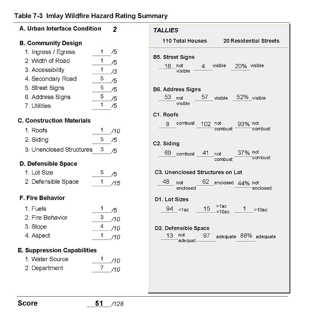 |
Figure 7-1Suppression Resources, Critical Community Features, and Fire History for the Community of Imlay |
 |