![]()
![]()
2.0 Description of the County
2.1 Demographics, location, topography, and climatic data
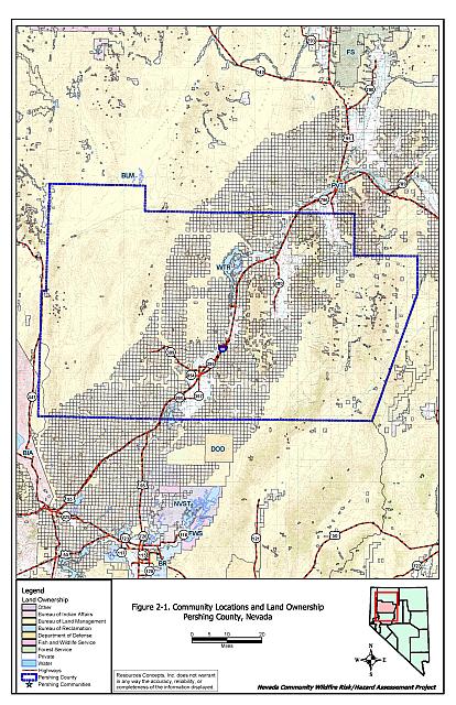
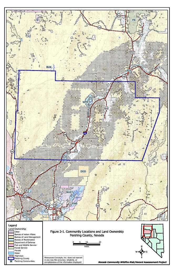
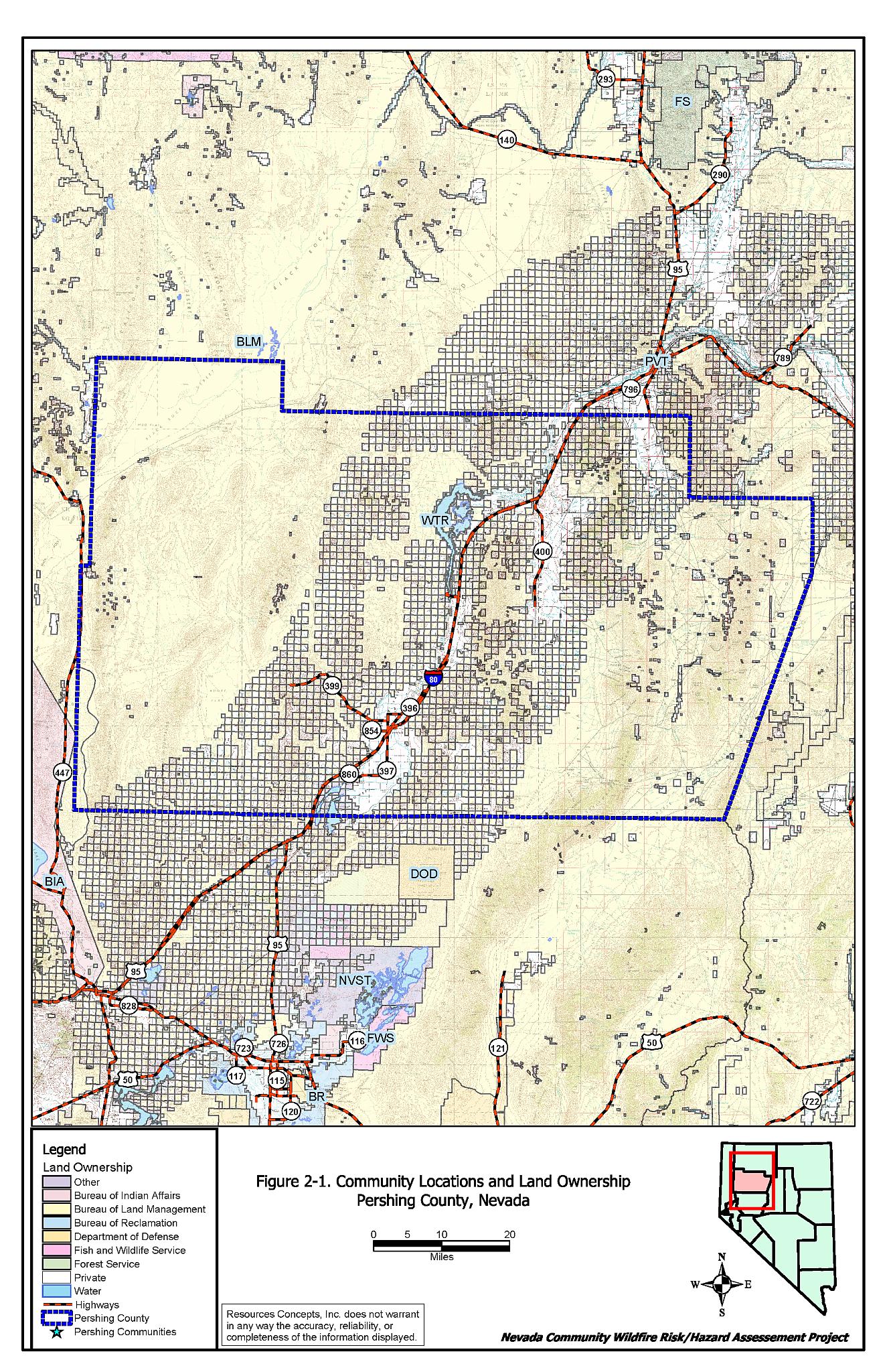
Pershing County is situated in the northern portion of Nevada and is approximately 3.8 million acres in size. Figure 2-1 illustrates community locations and land ownership in Pershing County. A summary of land management acreage is provided in Table 2-1.
| Land Administrator | Acreage |
|---|---|
| BLM | 2,907,582 |
| Bureau of Reclamation | 8,849 |
| State of NV | 7,082 |
| Private | 937,917 |
| Other | 20,195 |
| Approximate values derived from BLM land ownership GIS database. | |
The County population based on 2002 federal statistics is 6,638 (NV State Demographer’s Office, 2003). The Pershing County economy is based primarily in government, mining and trades. The Nevada State Demographer’s Office lists Couer-Rochester, Inc., Eagle-Picher Industries, and the Pershing County School District as the largest employers in the County.
Elevations within the County range from 9,396 feet at Sonoma Peak to 3,975 feet at Lovelock. Primary mountain ranges include the Humboldt Range, the Trinity Range, the East Range and the Tobin Range. A portion of the Black Rock Desert lies in the uppermost northwestern corner of the County. Major valleys are Pleasant Valley, Buena Vista Valley, and Granite Springs Valley. Climate ranges from the low 40’s in December and January to the low 90’s in July and August. The county averages about five to seven inches of rainfall per year.
2.2 Wildfire History
The fire history of Pershing County was researched through the Nevada BLM State office. There have been significant wildfires in the recent history of Pershing County. From 1980 through 2003, over 640,000 acres or 17 percent of the land in Pershing County burned. In recent years, especially 1999 through 2001, extensive acreages have burned within the County. The majority of these fires occurred along the Interstate 80 corridor, and in many cases acreage that burned in previous years has burned repeatedly. The frequent fire return interval in these areas has corresponded with a transition of the native ecological site to a cheatgrass dominated community. Cheatgrass monocultures are usually characterized by fire return intervals of five years or less, whereas the native salt desert shrub sites and Wyoming sagebrush sites generally have fire return intervals greater than 50 years in length. The fuel type conversion to a cheatgrass dominated site results in flashy fuels that are easily ignited and burns more rapidly than native vegetation. Depending on the density of the cheatgrass stand it may have shorter flame lengths than fire events in the native vegetation.
Effect of Cheatgrass on Fire Ecology
The science of fire ecology is concerned with understanding how fire contributes to plant community structure and species composition. A fire regime is defined as the frequency and severity of fire occurrence in a given plant community. Fire frequency is controlled by the period of time required for the vegetation to recover from fire and reestablish vertical and horizontal continuity in the fuel beds. Natural fire regimes have been affected throughout most of Nevada by twentieth century fire suppression policies. Areas that formerly burned with high frequency but low intensity (fires more amenable to control and intervention) are now characterized by large accumulations of unburned fuels, which once ignited, will burn at higher intensities.
Big sagebrush is the most common plant community in Nevada with an altered fire regime now characterized by infrequent, high-intensity fires. Sagebrush requires a significant amount of time to reestablish on burned areas providing the conditions for establishment and spread invasive species; most commonly cheatgrass (Bromus tectorum) in northern Nevada.
Cheatgrass is a common introduced annual grass that aggressively invades disturbed areas. Replacement of a native shrub community with a cheatgrass monoculture increases the wildfire ignition risk, especially in late summer when desiccating winds and lightning activity are more prevalent. Once established, cheatgrass can become locked into an intractable fire cycle with a regular return interval of less than five years. It is therefore considered a high hazard fuel type.
While this fuel type can pose a low fire behavior hazard, being light and tending to burn with a relatively low intensity, it presents an extreme ignition risk with the propensity to rapidly burn out of control and ignite higher-hazard fuel types.
The strategy to control cheatgrass once established is to deplete the soil seedbank by mowing defensible space and firebreak areas annually before seed set, and on a larger, landscape scale, by implementing early-season intensive grazing up to and during flowering.
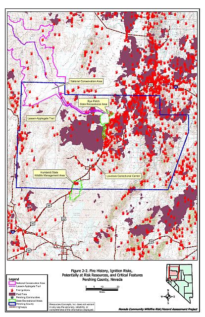
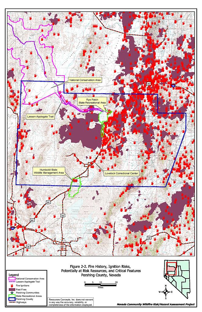
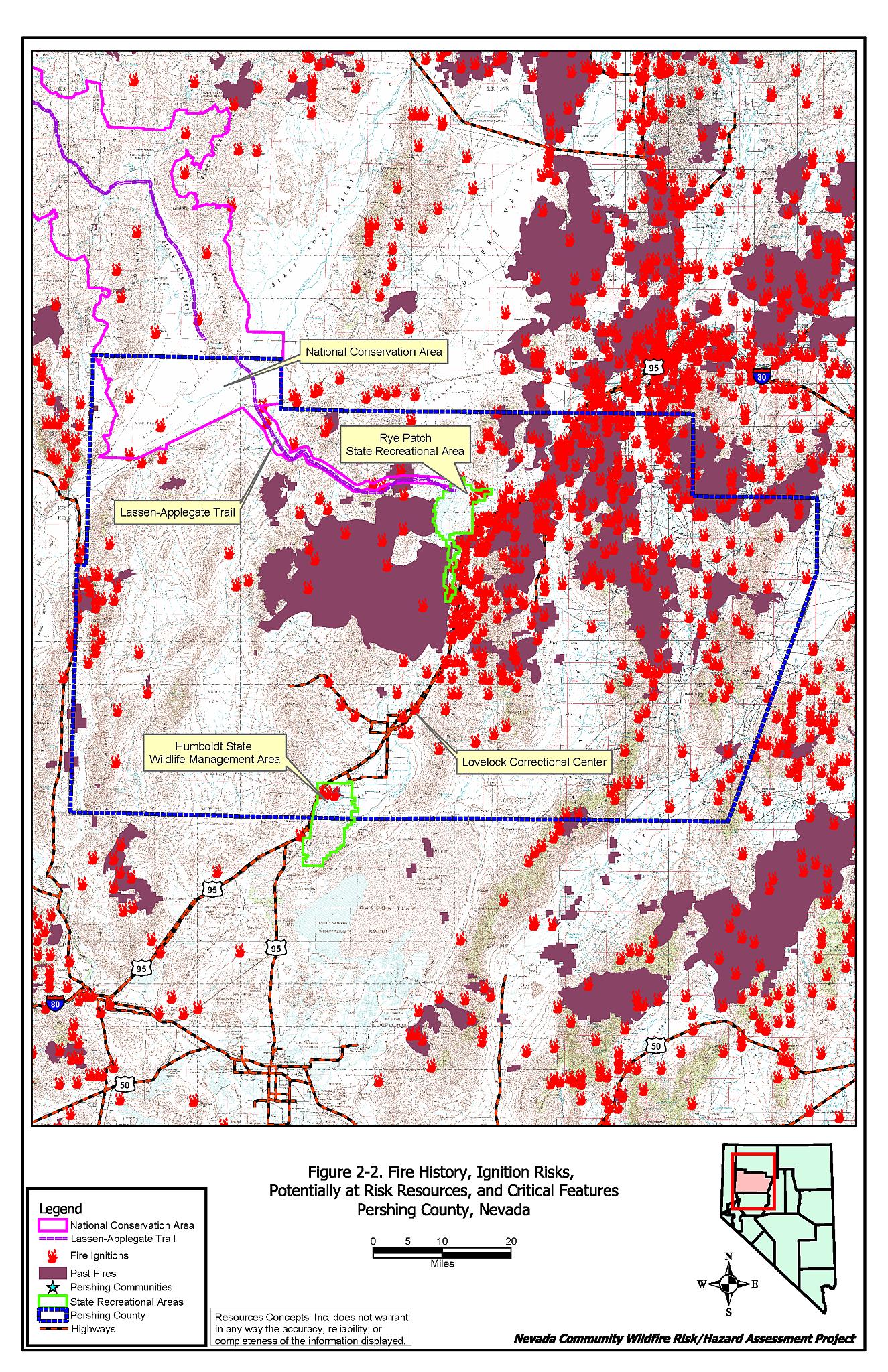
Table 2-2 summarizes the fire histories and fire ignitions by year. The wildfire history within the County is shown on Figure 2-2.
| Year | Number of Fires[1] | Number of Fire Ignitions[2] | Total Reported Fire Acreage[3] | Total Fire Acreage w/in Pershing County |
|---|---|---|---|---|
| 1980 | NA | 3 | 2,531 | NA |
| 1981 | NA | 5 | 853 | NA |
| 1982 | NA | 8 | 2,423 | NA |
| 1983 | NA | 11 | 261 | NA |
| 1984 | NA | 31 | 11,287 | NA |
| 1985 | 5 | 45 | 69,170 | 42,735 |
| 1986 | 6 | 16 | 8,118 | 8,118 |
| 1987 | 1 | 9 | 16,917 | 16,916 |
| 1988 | NA | 21 | 4,962 | NA |
| 1989 | 1 | 15 | 4,042 | 4,042 |
| 1990 | NA | 16 | 1,380 | NA |
| 1991 | 1 | 22 | 419 | 419 |
| 1992 | NA | 12 | 84 | NA |
| 1993 | NA | 10 | 2 | NA |
| 1994 | NA | 12 | 1,030 | NA |
| 1995 | 3 | 28 | 15,934 | 15,933 |
| 1996 | 5 | 31 | 10,020 | 9,702 |
| 1997 | NA | 20 | 830 | NA |
| 1998 | 8 | 11 | 22,029 | 16,874 |
| 1999 | 73 | 49 | 364,721 | 364,682 |
| 2000 | 21 | 24 | 54,046 | 44,084 |
| 2001 | 20 | 29 | 148,744 | 117,160 |
| 2002 | 2 | 15 | 1,182 | 1,182 |
| 2003 | NA | 6 | 3 | NA |
| Unknown | 16 | 2,900 | 2,900 | |
| TOTAL | 146 | 459 | 743,888 | 644,747 |
| [1] Fire history provided by the Nevada BLM State office as spatial data (polygon format). No data is available for the years of 1980-1984, 1988, 1990, 1992-1994, 1997, and 2003. 16 fire polygons in Pershing County have no date associated with them. [2] Fire ignitions provided by the National Interagency Fire Center (NIFC), Boise, Idaho as spatial data (point format). [3] Acreage is provided by the Nevada BLM spatial data when available, otherwise acreage is derived from the NIFC data. | ||||
2.3 Natural Resources and Critical Features Potentially at Risk
There are no Federally or State Listed threatened or endangered species in Pershing County according to the Nevada Natural Heritage Program database (search date 10 February 2004). The sage grouse (Centrocercus urophasianus) is included on the BLM sensitive species list, and is vulnerable to the loss of sagebrush habitat due to wildfire.
The Rye Patch Recreation Area includes the Rye Patch Reservoir and the Upper-and-Lower Pitt-Taylor Reservoirs, both popular for outdoor recreation and fishing.
Humboldt Wildlife Management Area is located approximately 12 miles southwest of Lovelock on the east side of Interstate 80. The 38,724-acre WMA is managed by the Nevada Department of Wildlife. Hunting, fishing and camping are the primary recreational activities in the area. Campfires are permitted in designated campgrounds.
The Applegate-Lassen Trail, listed on the National Register of Historical Places, crosses through Pershing County from Rye Patch northwest to the state Line in the Black Rock Desert. This was one of the major trails providing access into California and Oregon, also called the California Cutoff after it left the Oregon Trail near Fort Hall, Idaho. There are 19 remnant structures on the Pershing County portion of the Trail.
The locations of the Rye Patch Recreational Area, the Applegate-Lassen Trail, and the Humboldt WMA are shown on Figure 2-2.
Critical Community Features include tactical resources (schools, hospitals, police and fire dispatch), economic assets (agricultural and industrial resources), and cultural features (historic structures, archaeological sites, recreation and tourist centers) that could be used as a resource for controlling a wildfire, or at risk for loss during a wildfire event.
Key tactical resources include schools, often used as staging areas or incident command centers during a fire event, police and fire stations for their dispatch capacities, and hospitals.
Critical features for each community are shown on the community map at the end of each Community Assessment.
2.4 Previous Fire Hazard Reduction Projects
Pershing County experienced large wildland fires in the late 1990’s. As a result of these fires and the risk of recurring fires in these areas, some communities and fire suppression agencies have undertaken fire hazard reduction projects. The severe nature of the previous fires in Pershing County has also heightened the awareness of some communities to become more proactive in their fire hazard reduction efforts.
Over the past few years, the following projects have been undertaken in Pershing County:
- The BLM has conducted a public education program focusing on ways to be fire safe when traveling through public lands;
- The BLM has established a greenstrip around Mill City;
- A brush clearance program was established in Rye Patch;
- Vegetation in the road corridors in Rye Patch are sprayed annually with a herbicide;
- Volunteer firefighters in Grass Valley have received wildland firefighting training;
- A Family Safety Day public education program was recently held in Grass Valley.
Figure 2-1Community Locations and Land Ownership, Pershing County, Nevada |
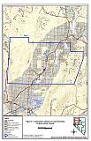 |
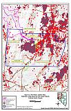
Figure 2-2Fire History, Ignition Risks and Potentially At-Risk Resources |
 |