![]()
![]()
11.0 Silver City
11.1 Hazard and Risk Assessment
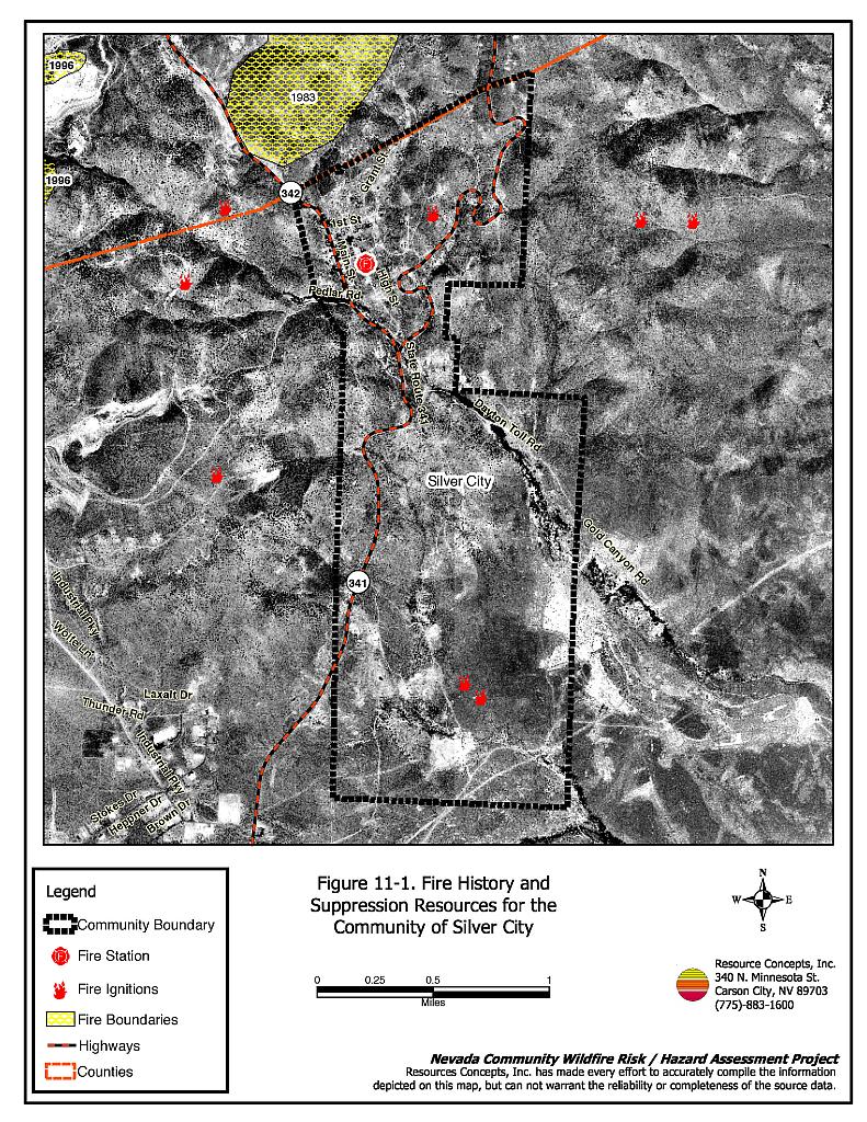
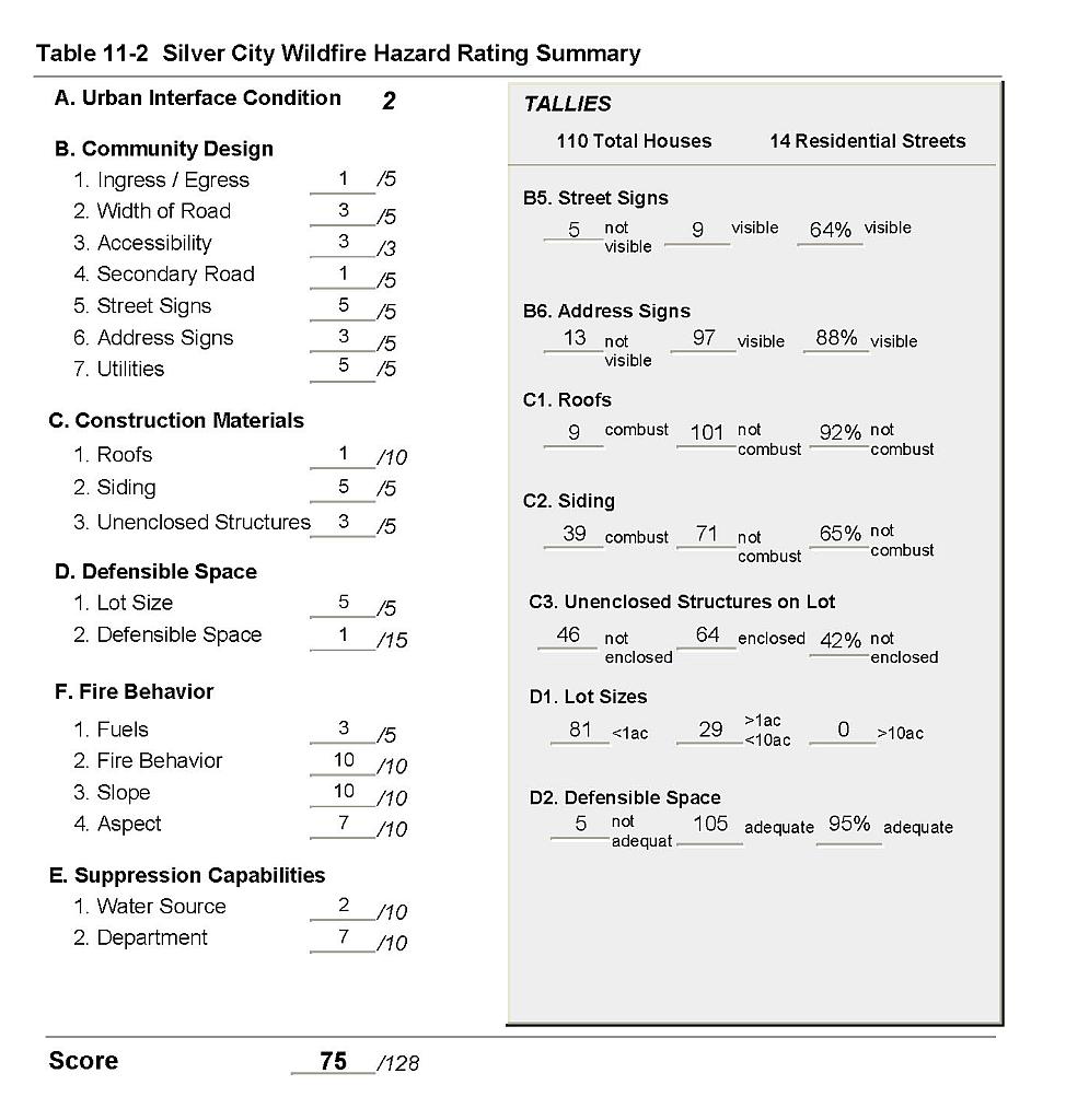
Silver City is a small historic town located in northwest Lyon County, adjacent to the Storey County line (see Figure 11-1). The town is located in Gold Canyon in the Virginia Range along State Route 341. Approximately 110 residences were evaluated during the assessment. The risk/hazard assessment resulted in classifying Silver City in the High Hazard category (75 points). The high community hazard rating is attributed primarily to flammable home construction materials, steep topography, and lack of defensible space. The community wildfire hazard score sheet is provided at the end of this section. The specific findings for each of the wildland fire assessment parameters are reported below.
11.1.1 Community Design
Silver City has an intermixed urban interface condition. Residences are scattered throughout continuous wildland fuels. Lot sizes are primarily less than one acre, with a small number of lots between one and ten acres. Structure spacing varies according to lot size.
Roads: The primary access routes in Silver City are State Route 341, including both primary and truck routes. Both of these roads are between 20 and 24 feet wide allowing adequate room for fire suppression equipment to maneuver. Road grades are typically less than five percent throughout the community.
Signage: Most streets in Silver City have standard metal street signs that are highly visible and easy to read. Residential addresses are easily visible on a majority of homes in Silver City. Clear and visible signage is important to assist fire suppression personnel in locating residences during poor visibility conditions that may exist during a wildland fire.
Utilities: The utilities that serve Silver City are primarily above ground power lines and above ground propane tanks. Power line right-of-ways have not been properly maintained and there is vegetation in the right-of-ways and around the power poles. Sparking power lines could start fires in this nearby vegetation during windstorms. During a fire there is high potential for power poles to be burned, thus cutting off power to the community.
11.1.2 Construction Materials
In keeping with the historical character of Silver City, over one-third of the homes were constructed with old, weathered and highly flammable siding materials. A majority of the homes observed in the interface area had fire resistant roof materials such as composition shingles, metal, or tile roofing. About one-third of the homes observed had unenclosed balconies, porches, decks or other architectural features that can create drafty areas where sparks and embers can be trapped, smolder, and ignite, rapidly spreading fire to the home.
11.1.3 Defensible Space
The majority of the homes had landscaping that would meet the defensible space landscape requirement to protect the home from damage or minimize loss during a wildfire. However, there were several exceptions with excessive vegetation and debris in close proximity to residences.
11.1.4 Suppression Capabilities
Wildfire Protection Resources
The location of the fire station in Silver City is shown in Figure 11-1. Wildfire protection is provided by the Central Lyon County Fire Protection District. Refer to Section 4.2 for more information on equipment and resources available.
Water Sources and Infrastructure
Water availability for fire suppression in Silver City is provided by Storey County and includes:
- Community wells
- 500 gpm hydrants within 1,000 feet of structures, and
- A water storage tank
The community water system operates on gravity and electric pumps. There is no backup generator for the water system.
11.1.5 Factors Affecting Fire Behavior
Most of the vegetative fuel surrounding Silver City was reestablished after the 1983 fire, with some unburned islands of pinyon, juniper, and sagebrush. Recovering burned areas were dominated by cheatgrass and bottlebrush squirreltail ground fuel with occasional sagebrush, bitterbrush, greasewood, and rabbitbrush shrubs. Shrubs were generally one to two feet tall. The total fuel load was estimated to be light at a rate of one to one and one-half tons per acre. The fuel hazard was estimated to vary from moderate to high depending upon annual cheatgrass production in this area.
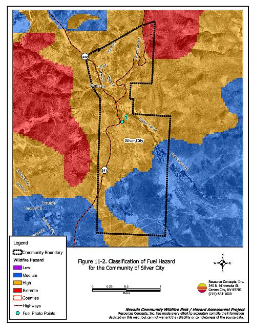
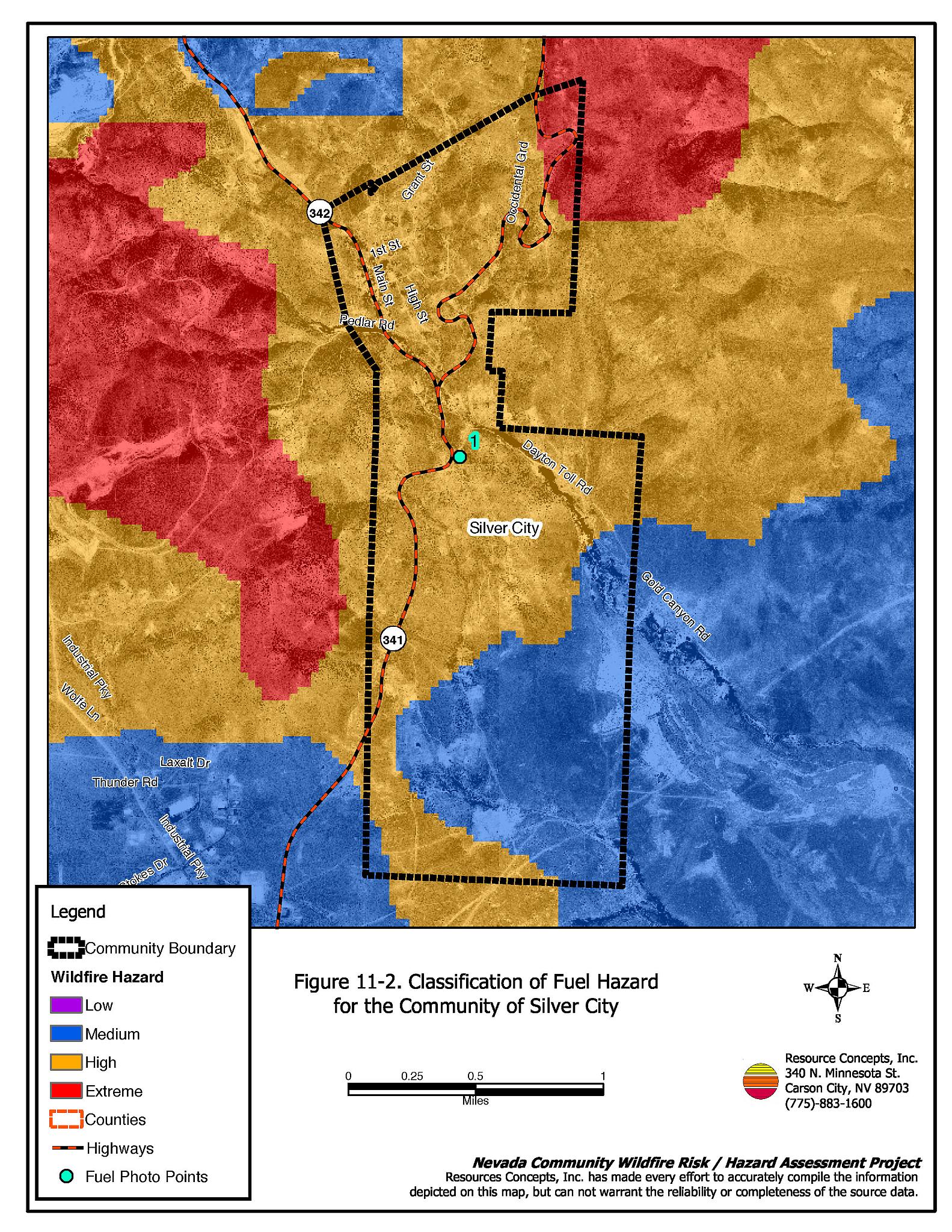
The fuels occurring on the unburned west side of the community were dominated by dense pinyon and juniper trees up to fifteen feet in height. The shrub layer included sagebrush, Mormon tea, bitterbrush and greasewood. Grasses in the understory were bottlebrush squirreltail and cheatgrass. Shrub height was generally one to two feet. Fuel loads were estimated between four and six tons per acre and were considered an extreme fuel hazard. Fuel hazard mapping and photo point locations are shown on Figure 11-2; fuel hazard photos are shown in Figure 11-3 at the end of this section.
11.1.6 Fire Behavior Worst-case Scenario
The topography around Silver City plays a major role in the potential fire behavior surrounding the community. The community is situated in a narrow canyon, with additional smaller canyons in the adjacent mountains. Slopes range from five to 45 percent, and the aspect is predominantly south. An ignition south or southwest of the community would likely be wind-driven with rapid rates of spread up Gold Canyon. Flame lengths of a wind-driven fire could reach four to ten feet in length spreading fire at an estimated rate 1,300 to 2,600 feet per hour. In a normal to above normal precipitation year, with high cheatgrass production, spread rates could increase. Volunteer members of the Silver City Volunteer Fire Department may have jobs outside of Silver City. The number of firefighters available for rapid initial attack could be limited during normal workdays. If available, and not previously dispatched to other incidents, additional mutual aid resources would come from the nearby communities of Dayton, Mound House, Six-Mile Canyon, and Virginia City.
There is a high risk for structure losses in the event of a wildfire due to the limited number of volunteer firefighters, the number of homes without fire resistant siding, and the potential for rapid spread rates due to the topography in the area.
11.1.7 Ignition Risk Assessment
Silver City has a high risk of fire ignition based upon the summer lightning strike history.
11.2 Risk and Hazard Reduction Recommendations, Roles, and Responsibilities
The responsibility to keep a community fire safe falls not only on the local fire protection district but also on the residents of the community, businesses, and local governments. The recommendations for Silver City focus primarily on additional efforts that can be taken by community members and public agencies to increase wildfire safety through reduction of hazardous fuels. Other recommendations pertain to community coordination and public education efforts that could be undertaken to enhance fire safety in Silver City. The recommendations are detailed below and summarized in Table 11-1.
11.2.1 Defensible Space Treatments
The density and type of fuel around a home affects the potential fire exposure levels to the home. The goals of defensible space are to reduce the chances of a wildfire spreading onto adjacent property and igniting homes, and to reduce the risk of property loss from wildfire. General guidelines for creating defensible space around residences and structures in the community are given below and are described in detail in Appendix E.
Property Owner Responsibilities
- Remove, reduce, and replace vegetation to create defensible space around homes according to the guidelines in Appendix E. This area should be kept:
- Lean: There are only small amounts of flammable vegetation
- Clean: There is no accumulation of dead vegetation or other flammable debris
- Green: Existing plants are healthy and green during the fire season.
- Immediately dispose of cleared vegetation when implementing defensible space treatments. This material dries quickly and poses a fire hazard if left on site.
- Maintain defensible space annually or as needed to keep the space lean, clean, and green.
- Where cheatgrass has become dominant within the defensible space area it should be mowed prior to seed set, or treated with an application of a pre-emergent herbicide prior to the onset of the growing season. Mowing may need to be repeated the following year to ensure that the seed bank of unwanted grasses has been depleted. Refer to Appendix E for suggested seed mixes and planting guidelines than can be used in conjunction with removal of cheatgrass.
- Store firewood a minimum distance of 30 feet from structures.
- Maintain areas under wood decks and porches free of weeds and other flammable debris. Install screens around unenclosed overhangs where possible.
- Clear all vegetation and combustible materials around propane tanks for a minimum distance of ten feet.
- Install spark arrestors on chimneys.
- Prune trees so that the branches are at least 15 feet away from chimneys and or structures.
11.2.2 Fuel Reduction Treatments
The following fuel reduction treatments are recommended to reduce the potential fire hazard.
Utility Company Responsibilities
- Reduce and remove vegetation to maintain 20 feet of clearance around power lines and utility poles near the community. Remove all tree limbs from power lines.
Central Lyon County Fire Protection District Responsibilities
- Remove or mow vegetation within ten feet of fire hydrants to improve visibility and access to fire personnel.
11.2.3 Community Coordination
Coordination among local, state, and federal fire suppression agencies is important in the day-to-day fire prevention activities and becomes critical in the event of a wildland fire. During a fire event, firefighters from other communities and states may be dispatched to protect areas they have never been before. This is particularly true in areas that have limited fire suppression resources and will most likely depend on outside assistance in the event of a catastrophic wildland fire. The following are recommendations should be implemented in Silver City to promote interagency and community coordination.
Property Owner Responsibilities
- Form a local chapter of the Nevada Fire Safe Council. The Nevada Fire Safe Council facilitates solutions to reduce the loss of lives and property from the threat of wildfire in Nevada’s communities. Through the establishment of a local Chapter, local communities will become part of a large network for sharing information and receive notifications of programs and funding opportunities for fire mitigation projects such as those listed in this report. The Nevada Fire Safe Council will accept and manage grants and contracts on the Chapter’s behalf through its non-profit status. The Nevada Fire Safe Council will provide assistance and support to communities to complete fire safe plans, set priorities, educate and train community members and promote success stories of its members. To form a local Chapter or for more information contact the:
Nevada Fire Safe Council
1187 Charles Drive
Reno, Nevada 89509
(775) 322-2413
www.nvfsc.org - Assure that residential addresses are visible from the road. Address characters should be at least four inches high, reflective, and composed of non-flammable material. Improving visibility of addresses will make it easier for those unfamiliar with the area to navigate under smoky conditions in the event of a wildland fire.
11.2.4 Public Education
Public education focused on increasing community fire safety is critical. Informed community members can provide the leadership necessary to initiate efforts to effectively reduce the threat that wildland fires present to the entire interface community.
Central Lyon County Fire Protection District Responsibilities
- Distribute copies of the publication Living with Fire to all property owners. This publication is free of charge. Copies can be requested from the University of Nevada Cooperative Extension.
- Enforce or develop county laws, regulations, and ordinances that support implementation and maintenance of defensible space and address fuel reduction responsibilities for absentee homeowners and vacant lots.
- Contact the University of Nevada Cooperative Extension and the BLM Carson City Field Office for assistance with public education.
11.3 Summary of Recommendations
| Responsible Party | Recommended Treatment | Recommendation Description |
|---|---|---|
| Property Owners | Defensible Space Treatments | Remove, reduce, and replace vegetation around homes according to the guidelines in Appendix E. Maintain defensible space as needed to keep the space lean, clean, and green. |
| Access | Improve address visibility. | |
| Community Coordination | Form a local chapter of the Nevada Fire Safe Council. | |
| Utility Company | Fuel Reduction Treatments | Reduce and remove vegetation around power lines and utility poles. Maintain 20 feet of clearance around power lines. |
| Central Lyon County Fire Protection District | Fuel Reduction Treatments | Remove or mow vegetation within ten feet around fire hydrants to improve visibility and access. |
| Public Education | Distribute copies of the publication Living with Fire to all property owners. Enforce or develop county laws and ordinances for defensible space and fuel reduction responsibilities for absentee owners and vacant lots. Contact the Nevada Cooperative Extension and BLM for assistance with public education. |
Figure 11-1Fire History and Suppression Resources for the Community of Silver City |
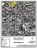 |
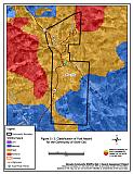
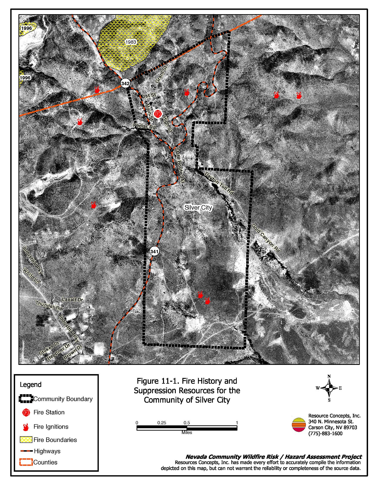
Figure 11-2Classification of Fuel Hazard for the Community of Silver City |
 |
Fuel Hazard Photo Points for the Community of Silver City
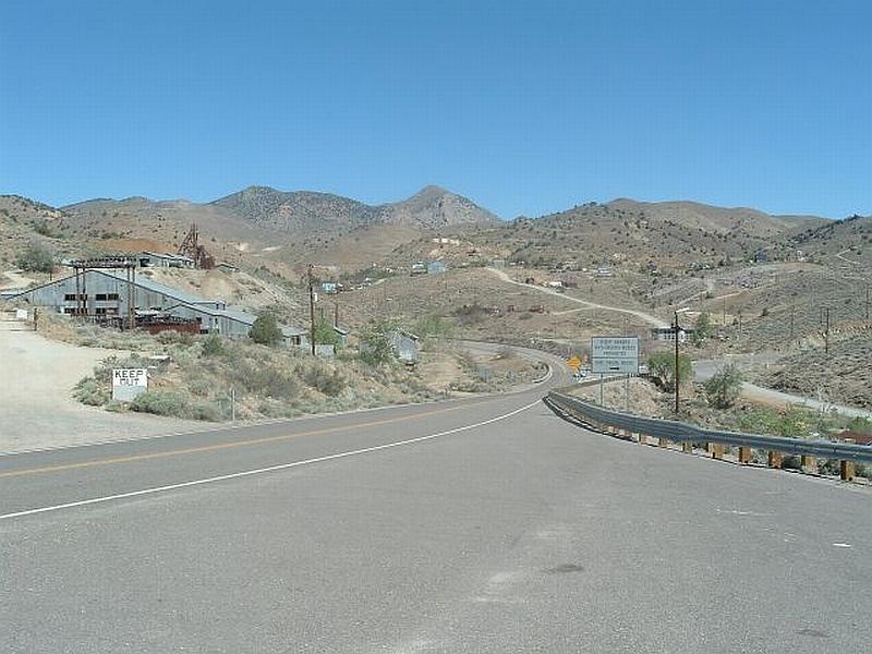
Photo Point 1. 4348264 N. 0272714 E. Direction 330°NW. Most of the area surrounding Silver City is dominated by species that have reestablished after the fire in 1983. Recovering burned areas are comprised of scattered sagebrush, bitterbrush, greasewood, and rabbitbrush shrubs, dominated by cheatgrass and bottlebrush squirreltail ground fuel. The total fuel load was estimated to be light at a rate of 1.0 to 1.5 tons per acre. The fuel hazard can range from moderate to high depending upon annual cheatgrass production in this area.
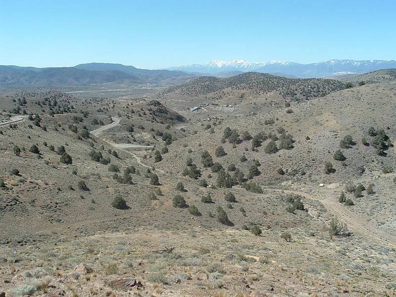
Photo Point 2. 0438264 N. 0272714 E. Direction 205° SW. The burned areas east of Silver City are considered a moderate hazard due to cheatgrass production (foreground). The unburned areas on steep slopes west of the community are dominated by pinyon and juniper trees with a sagebrush understory. This condition is considered an extreme fuel hazard (background).
Silver City Wildfire Hazard Rating Summary |
 |