![]()
![]()
9.0 Mason Valley
9.1 Hazard and Risk Assessment
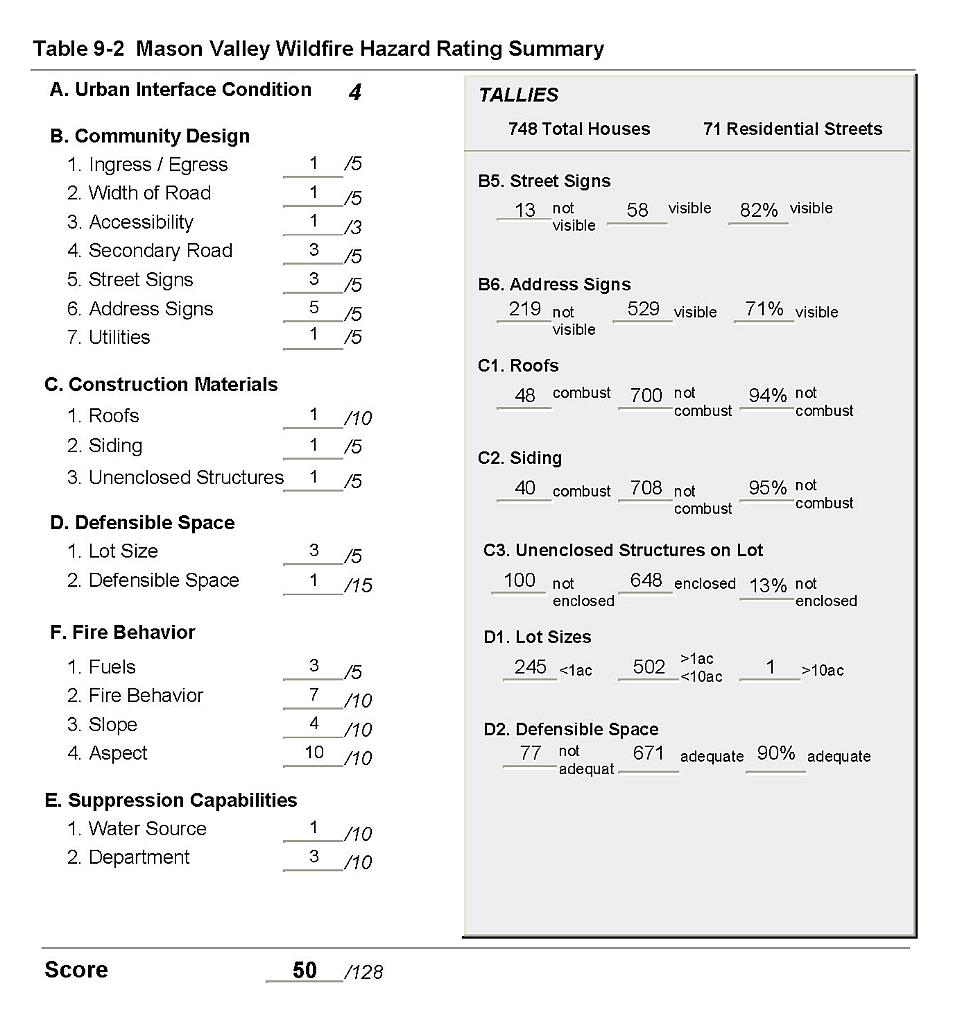
Mason Valley is a large valley comprised primarily of large agricultural parcels. The valley is situated in central Lyon County (see Figure 9-1). The south part of the valley is dissected by the East and West forks of the Walker River, and the two forks converge in the center of the valley. The valley is bordered to the west by the Singatse Range, to the east by the Wassuk Range, to the southeast by the Gray and Cambridge Hills, to the south by the Pine Grove Hills, and to the north by the Desert Mountains. Mason Valley is the setting of the Yerington, Wabuska, Weed Heights, and Mason communities. The community of Mason was assessed with Mason Valley. Other Mason Valley communities are addressed individually in separate chapters. A total of 748 residences were evaluated during the assessment. The risk/hazard assessment resulted in classifying Mason Valley in the Moderate Hazard category (50 points). The moderate community hazard rating is attributed primarily to the number of homes without visible addresses and the potential for erratic fire behavior near the community. The community wildfire hazard score sheet is provided at the end of this section. The specific findings for each of the wildland fire assessment parameters are reported below.
9.1.1 Community Design
Mason Valley is complex and can be described as combinations of intermix, occluded, rural, and classic interface conditions. In some areas subdivisions border wildland fuels with a clear line of demarcation between the fuels and the residences; however, where homes have been built on larger lots wildland fuels can be contiguous up to each residence. In other areas structures are located adjacent to “islands” of wildland fuels or in small clusters exposed to wildland fuels. Lot sizes vary throughout Mason Valley with the majority of lots between one and ten acres. Structure spacing varies according to lot size.
Roads: The primary access routes in Mason Valley are State Routes 339 and 208, which are paved highways greater than 24 feet wide and provide adequate room for fire suppression equipment to maneuver. Primary and secondary roads have grades less than five percent and have adequate turnaround space at road terminus points for fire suppression equipment to maneuver.
Signage: The majority of residential streets in Mason Valley have standard metal street signs that are highly visible and easy to read. Residential addresses are easily visible on about two-thirds of homes in Mason Valley. Clear and visible residential addresses are important to aid fire-fighting personnel in locating homes during low visibility conditions that may be present during a wildland fire.
Utilities: The utilities that serve Mason Valley are a combination of above ground and below ground power lines with scattered areas served by propane. In general utilities have adequately maintained right-of-ways and pose only a low ignition risk to the community.
9.1.2 Construction Materials
A majority of the homes observed in the interface area were built with fire resistant siding materials. A great majority of the homes had fire resistant roof materials such as composition shingles, metal, or tile roofing. Very few of the homes observed had unenclosed balconies, porches, decks or other architectural features that can create drafty areas where sparks and embers can be trapped, smolder, and ignite, rapidly spreading fire to the home.
9.1.3 Defensible Space
The vast majority of the homes had landscaping that would meet the defensible space requirement to protect the home from damage or minimize loss during a wildfire.
9.1.4 Suppression Capabilities
Wildfire Protection Resources
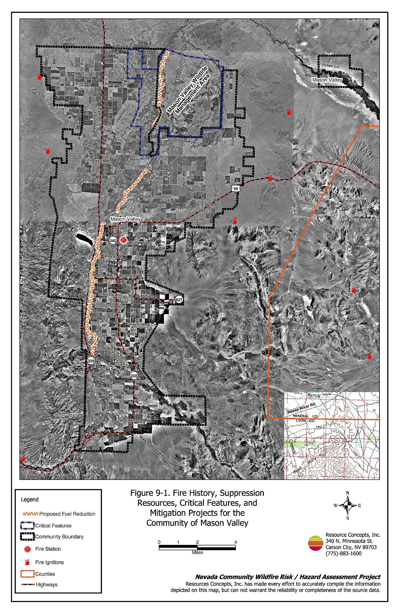
The Mason Valley Fire Protection District provides wildfire protection. The location of the Mason Valley fire station is shown on Figure 9-1. Refer to Section 4.2 for more information on equipment and resources available.
Water Sources and Infrastructure
Water availability for fire suppression in Mason Valley varies depending upon location and includes areas with:
- Community wells.
- 500 gpm hydrants within 500 feet to 1,000 feet of structures.
- Water storage tanks between 3,000 and one million gallons.
- Water drafting sources including the cooling ponds at the power station, the Walker River, and agricultural water storage tanks that can be used with landowner permission.
The community water system operates on gravity and electric pumps, with backup diesel generators.
9.1.5 Factors Affecting Fire Behavior
The Walker River bisects Mason Valley and a large portion of the valley is irrigated agricultural land. The topography within Mason Valley is flat with slopes generally less than two percent. The Wilson Canyon area south of Mason Valley is steeper with slopes up to 30 percent. The predominant wind direction is from the west or southwest.
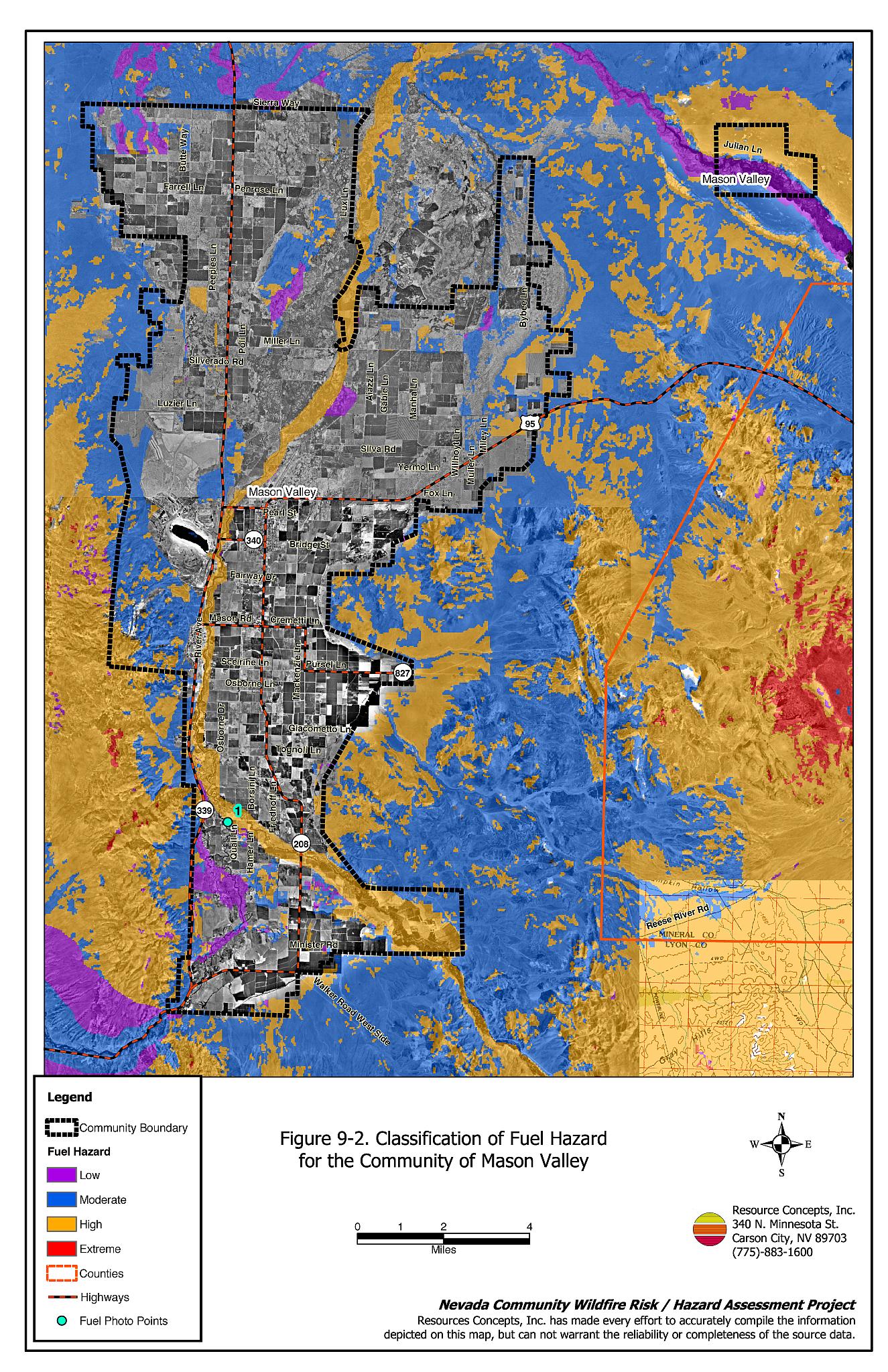
Irrigated agricultural lands are fire resistant during the majority of the fire season and present a very low fuel hazard.
Fuels along the river corridor included a tree canopy layer of willow, cottonwood, tamarisk, and Russian olive. The predominant shrubs were black greasewood and four-wing saltbush. The grass layer was comprised of both riparian grass and sedges with upland species of saltgrass, Indian ricegrass, and bottlebrush squirreltail. Fuels within the river corridor were dense and in some areas formed a closed canopy condition. The shrub layer was approximately five to six feet in height and the tree layer ranged between 15 and 60 feet in height. Fuels loads were estimated between 20 and 30 tons per acre and were considered moderate to high fuel hazard.
The fuels along the west side of Mason Valley were primarily composed of salt desert shrub communities. Dominant species included greasewood, spiny hopsage, Mormon tea, shadscale, budsage, Indian ricegrass, cheatgrass, and Russian thistle. Shrubs were sparsely spaced five to 20 feet apart and were generally between one and two feet in height. The estimated fuel load was less than one ton per acre and was considered a low fuel hazard.
Fuels along the east side of the valley also consisted of salt desert shrub vegetation dominated by greasewood, winterfat, and Indian ricegrass. Shrubs in this area ranged in height from one to four feet and were spaced between five and 50 feet apart. The fuel load was estimated at less than one ton per acre and was considered a low fuel hazard.
9.1.6 Fire Behavior Worst-case Scenario
A worst-case fire behavior scenario would likely occur on a windy fall day, when the Walker River is almost dry and adjacent vegetation has desiccated. An ignition in the afternoon could spread quickly into a high-intensity fire with rapid spread rates through the dense fuels along the river corridor. Suppression capabilities may be limited in this area due to access problems.
9.1.7 Ignition Risk Assessment
Mason Valley was viewed as having a moderate risk of human caused fire ignition due to ditch burning and recreation activities such as camping, hunting, and fishing.
9.2 Risk and Hazard Reduction Recommendations, Roles, and Responsibilities
The responsibility to keep a community fire safe falls not only on the local fire protection district but also on the residents of the community, businesses, and local governments. The recommendations for Mason Valley focus primarily on additional efforts that can be taken by community members and public agencies to increase wildfire safety through reduction of hazardous fuels. Other recommendations pertain to community coordination and public education efforts that could be undertaken to enhance fire safety in Mason Valley. The recommendations are detailed below and summarized in Table 9-1.
9.2.1 Defensible Space Treatments
The density and type of fuel around a home affects the potential fire exposure levels to the home. The goals of defensible space are to reduce the chances of a wildfire spreading onto adjacent property and igniting homes, and to reduce the risk of property loss from wildfire. General guidelines for creating defensible space around residences and structures in the community are given below and are described in detail in Appendix E.
Property Owner Responsibilities
- Remove, reduce, and replace vegetation to create defensible space around homes according to the guidelines in Appendix E. This area should be kept:
- Lean: There are only small amounts of flammable vegetation
- Clean: There is no accumulation of dead vegetation or other flammable debris
- Green: Existing plants are healthy and green during the fire season.
- Immediately dispose of cleared vegetation when implementing defensible space treatments. This material dries quickly and poses a fire hazard if left on site.
- Maintain defensible space annually or as needed to keep the space lean, clean, and green.
- Store firewood a minimum distance of 30 feet from structures.
- Mow or remove brush growing against wood fences in the community.
- Reduce (mow or burn) vegetation and remove debris along irrigation channels and unlined ditches to reduce the fuel load.
- Maintain areas under wood decks and porches free of weeds and other flammable debris. Install screens around unenclosed overhangs where possible.
- Clear all vegetation and combustible materials around propane tanks for a minimum distance of 10 feet.
9.2.2 Fuel Reduction Treatments
The recommendation for fuel reduction treatments in Mason Valley is made in conjunction with recommendations for the community of Yerington given in Section 17.2. Several fires occur within the Walker River corridor every year. The following fuel reduction treatment should be implemented to reduce the potential wildfire hazard to homes located near the river and to wildlife habitat along the river corridor.
Property Owner and Lyon County Responsibilities
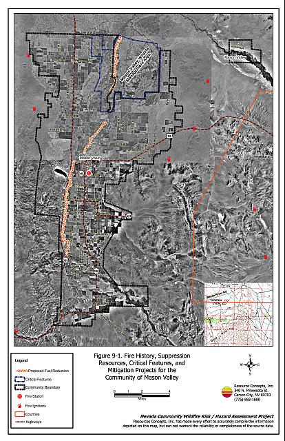
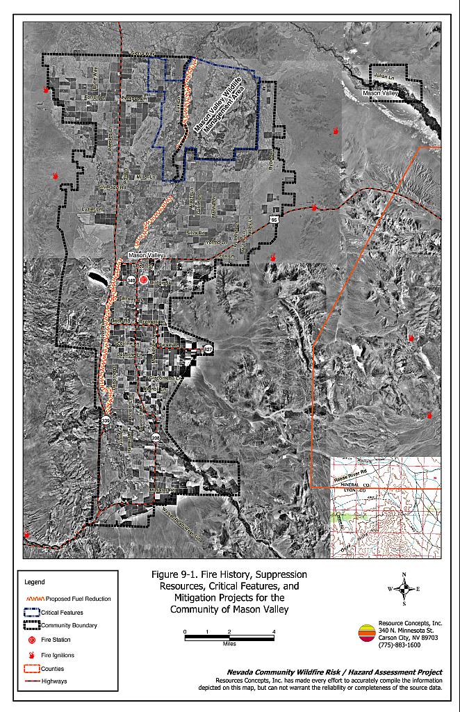
- Reduce the fuels along reaches of the Walker River corridor that do not have irrigated agricultural land on both sides of the River. Fuels should be reduced to approximately one ton per acre, prioritizing removal of dead wood and debris. Primary tree and brush species to target for thinning and removal include tamarisk, Russian olive, dead willow and cottonwood branches, greasewood, and four-wing saltbush. Live willow and cottonwood trees should not be removed but may be pruned to remove dead branches within the canopy. The treatment area should be between 100 and 300 feet wide on both sides of the river as shown on Figure 9-1. The total length of the treatment area is approximately 14.5 miles and totals approximately 175 to 525 acres.
- Landowners should coordinate with Nevada Department of Wildlife biologists and other interested parties to identify any special treatment specifications relative to wildlife habitat concerns.
9.2.3 Community Coordination
Coordination among local, state, and federal fire suppression agencies is important in the day-to-day fire prevention activities and becomes critical in the event of a wildland fire. During a wildfire event, firefighters from other communities and states maybe dispatched to protect areas they have never been before. This is particularly true in areas that have limited fire suppression resources and will most likely depend on outside assistance in the event of a catastrophic wildland fire. The following are recommendations that should be implemented in Mason Valley to promote interagency and community coordination.
Property Owner Responsibilities
- Join with Yerington to form a local chapter of the Nevada Fire Safe Council. The Nevada Fire Safe Council facilitates solutions to reduce the loss of lives and property from the threat of wildfire in Nevada’s communities. Through the establishment of a local chapter, local communities will become part of a large network for sharing information and receive notifications of programs and funding opportunities for fire mitigation projects such as those listed in this report. The Nevada Fire Safe Council will accept and manage grants and contracts on the chapter’s behalf through its non-profit status. The Nevada Fire Safe Council will provide assistance and support to communities to complete fire safe plans, set priorities, educate and train community members, and promote success stories of its members. To form a local chapter, or for more information contact the:
Nevada Fire Safe Council
1187 Charles Drive
Reno, Nevada 89509
(775) 322-2413
www.nvfsc.org - Assure that residential addresses are visible from the road. Address characters should be at least four inches high, reflective, and composed of non-flammable material. Improving visibility of addresses will make it easier for those unfamiliar with the area to navigate an area under smoky conditions in the event a wildland fire.
Nevada Department of Wildlife
- Develop guidelines and specifications for implementing fuel reduction treatments in the river corridor to address wildlife habitat concerns such as timing of implementation to minimize impacts during nesting, and pesticide application procedures for tamarisk removal.
9.2.4 Public Education
Public education focused on increasing community fire safety is critical. Informed community members can provide the leadership necessary to initiate efforts to effectively reduce the threat that wildland fires present to the entire interface community.
Mason Valley Fire Protection District Responsibilities
- Distribute copies of the publication Living with Fire to all property owners. This publication is free of charge. Copies can be requested from the University of Nevada Cooperative Extension.
- Enforce or develop county laws, regulations, and ordinances that support implementation and maintenance of defensible space and address fuel reduction responsibilities for absentee homeowners and vacant lots.
- Contact the University of Nevada Cooperative Extension and the BLM Carson City Field Office for assistance with public education.
9.3 Summary of Recommendations
| Responsible Party | Recommended Treatment | Recommendation Description |
|---|---|---|
| Property Owners | Defensible Space Treatments | Remove, reduce, and replace vegetation around homes according to the guidelines in Appendix E. Maintain defensible space as needed to keep the space lean, clean, and green. |
| Fuel Reduction Treatments | Reduce fuel loads along the Walker River corridor for a distance of approximately 14.5 miles and a width of 100 to 300 feet on both sides of the River where needed. | |
| Community Coordination | Form a local chapter of the Nevada Fire Safe Council. Improve address visibility. |
|
| Lyon County | Fuel Reduction Treatments | Work with landowners to coordinate fuel reduction activities along the Walker River. |
| Nevada Department of Wildlife | Community Coordination | Develop guidelines and work with landowners to implement fuel reduction treatments along the Walker River corridor. |
| Mason Valley Fire Protection District | Public Education | Distribute copies of the publication Living with Fire to all property owners. Enforce or develop county laws and ordinances for defensible space and fuel reduction responsibilities for absentee owners and vacant lots. Contact Nevada Cooperative Extension and the BLM for assistance with public education. |
Figure 9-1Fire History, Suppression Resources, Critical Features, and Mitigation Projects for the Community of Mason Valley |
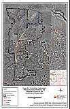 |
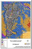
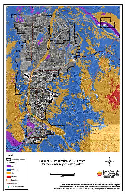
Figure 9-2Classification of Fuel Hazard for the Community of Mason Valley |
 |
Fuel Hazard Photo Point for the Mason Valley Community
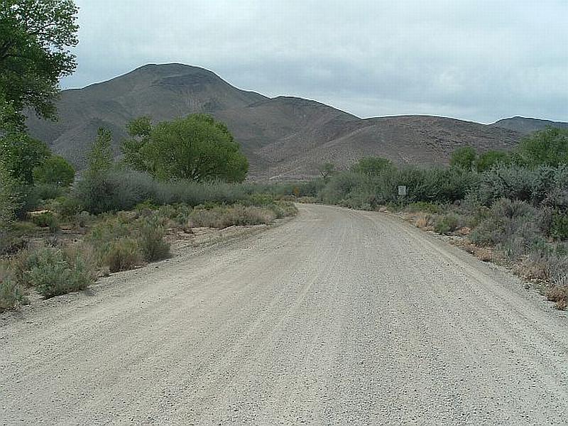
Photo Point 1. 0311232 N. 4306584 E. Direction 275°W. The riparian vegetation type located along the Waller River in Mason Valley was classified as having a high fuel density with fuel loads ranging between 20 and 30 tons per acre. Fuel reduction treatments are proposed along the river corridor to reduce the risk of wildfire ignition and spread into the community.
Mason Valley Wildfire Hazard Rating Summary |
 |