![]()
![]()
23.0 Spring Valley/Double Springs
23.1 SWCA Environmental Consultants Hazard Assessment and Mitigation Plan
In 2003, SWCA Environmental Consultants completed an assessment entitled “Wildfire Hazard Assessment and Mitigation Plan for the Spring Valley/Double Springs Community,” on behalf of the Nevada Fire Safe Council. The pertinent information for this report is summarized from the SWCA Spring Valley/Double Springs assessment.
The Spring Valley/Double Springs community is located along the west side of US Highway 395, 4.5 miles north of Holbrook Junction (US Highway 395 and State Route 208) and approximately twelve miles south of Gardnerville, Nevada. The major land ownership adjacent to the community includes both private land and 99-year leases from the Washoe Tribe of Nevada and California. The residences are generally located in both Double Springs Flat and Dead Horse Flat. Seventy-five structures were evaluated when the risk and hazard assessment was conducted for Spring Valley/Double Springs. The assessment resulted in classifying the Spring Valley/Double Springs community in the High Hazard category (adapted from the Wildfire Hazard Assessment and Mitigation Plan for the Spring Valley/Double Springs Community, September 2003). The primary hazard factor for the Spring Valley/Double Springs area was the limited defensible space implementation throughout the community.
23.1.1 Community Design
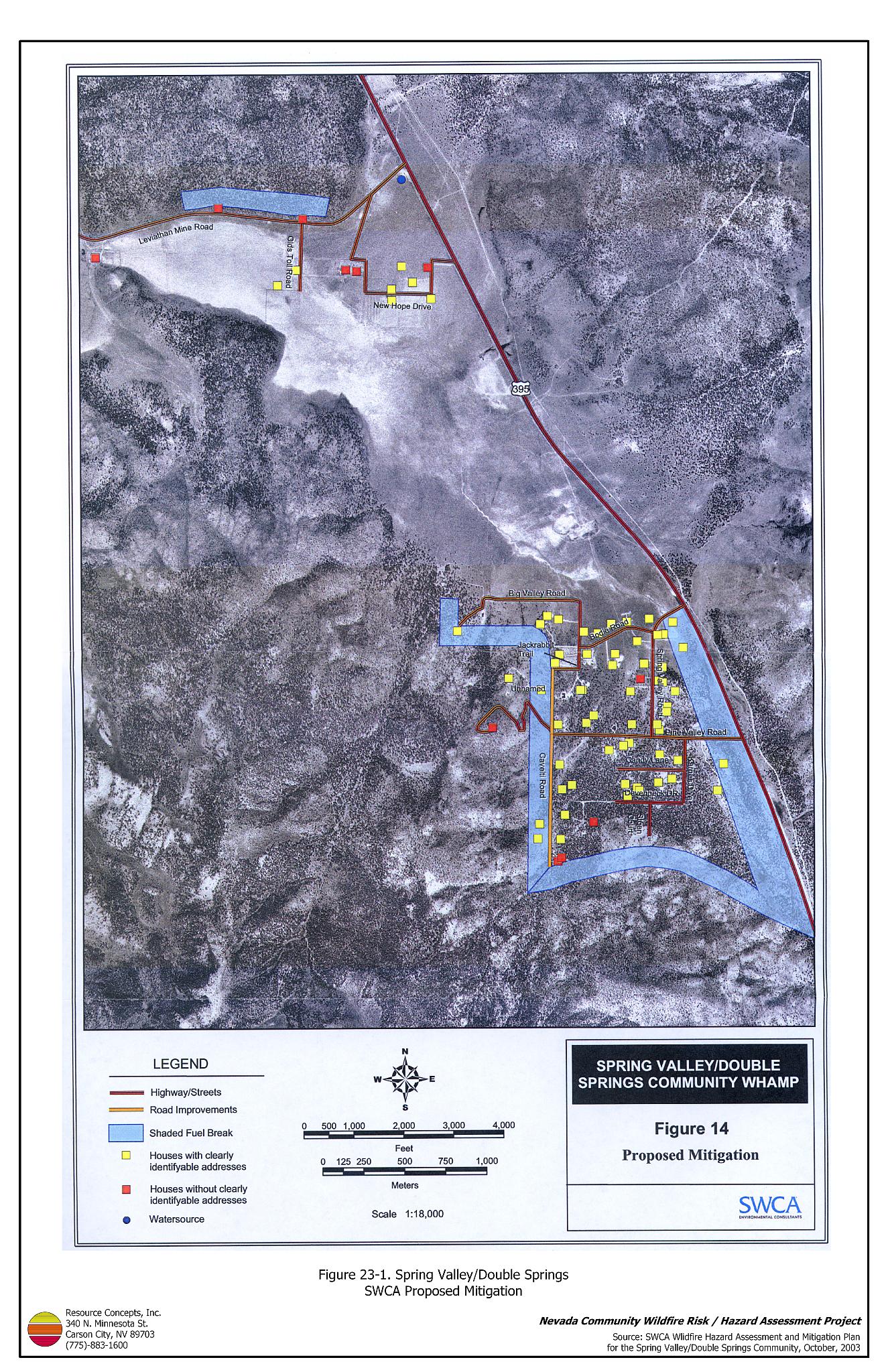
The Spring Valley/Double Springs interface area is characterized by the intermix wildland-urban interface condition. Structures are scattered throughout the wildland area with no clear line of demarcation between wildland fuels and residences in the community. A majority of the homes assessed were on parcels between three and forty acres. As such, most structures are not spaced close together (see Figure 23-1).
- Roads: US Highway 395 is the primary road connecting the Spring Valley/Double Springs community with other communities in Douglas County. Leviathan Mine Road, New Hope Drive, Bodie Road, and Pine Valley Road are the primary entrance and exit routes for residences in the community. US Highway 395 is paved and at least 24 feet wide, adequate width for two way-vehicle passage and fire suppression equipment to maneuver. Most secondary roads provide adequate width and turnaround space for fire suppression equipment to maneuver, except for Calveti Road.
- Signage: Residential addresses were visible on approximately 85 percent of the homes surveyed. Clear and visible residential addresses and street signs are important to aid firefighting personnel in locating homes during low visibility conditions that occur during a wildland fire.
- Utilities: The utilities in Spring Valley/Double Springs are above and below ground. Proper maintenance of power line corridors was not observed in all areas of the community. Reducing vegetation underneath and adjacent to power lines minimizes the possibility of power lines producing sparks during windstorms and starting fires in nearby vegetation.
23.1.2 Construction Materials
The majority of the homes in the community (83 percent) were built with Class C rated wood siding, which burns in less than twenty minutes. Approximately seven percent of structures were built with non-rated roofing materials. Less than thirty percent of homes observed have unenclosed balconies, porches, decks or other architectural features that create drafts and provide areas where sparks and firebrands can be trapped, smolder, ignite, and rapidly spread fire to the home.
23.1.3 Defensible Space
Between fifty and 99 percent of structures assessed in Spring Valley/Double Springs do not have landscaping that meets the minimum defensible space requirement to help protect the home from damage or loss during a wildfire. In Spring Valley/Double Springs the recommended minimum defensible space distance ranged between thirty and 200 feet depending upon slope and vegetation type. Refer to Appendix D for recommended seed mixes and planting guidelines.
23.1.4 Suppression Capabilities
Wildfire Protection Resources
Spring Valley/Double Springs is provided wildland and structure fire protection by both the East Fork Fire and Paramedic Districts Topaz Ranch Estates Volunteer Fire Department Station 4 (a combination career/volunteer station with two career members) and the Topaz Lake Volunteer Fire Department Station 5. The Topaz Ranch Estates VFD responded to 213 emergency calls in 2001. At the time that interviews were conducted for this report, the Topaz Lake VFD reported fourteen enrolled members who responded to 92 emergency calls in 2003. Station 4 actively conducts “Compost your Combustibles” and reflective address sign programs (East Fork Fire and Paramedic Districts website). See Tables 4-2 and 4-3 for more information on the typical fire suppression response for first-alarm wildland-urban interface fires in Douglas County. Appendix E lists the type and number of fire suppression vehicles located at each EFFPD and Douglas County VFD station.
The interagency wildland fire resources will also respond to wildland fire reports within the Spring Valley/Double Springs area to protect adjacent federal lands. The response will be initiated by the Sierra Front Interagency Dispatch Center.
Water Sources and Infrastructure
Water availability for fire suppression in Spring Valley/Double Springs includes two static 50,000-gallon tanks, one near the junction of US Highway 395 and Leviathan Mine Road, and the other near Penrod Lane in the Holbrook Junction Community. The tanks are not connected to wells and must be filled each fire season. No fire hydrants are available in the community. Topaz Lake may be used as a helicopter dip site and drafting source, however it is more than a twelve-mile round trip.
Community Preparedness
The Spring Valley/Double Springs community formed a local chapter of the Nevada Fire Safe Council in August of 2002. There is currently no evacuation plan for residents of the community, nor do the emergency and disaster plans provide information on safe zones within the community.
23.1.5 Factors Affecting Fire Behavior
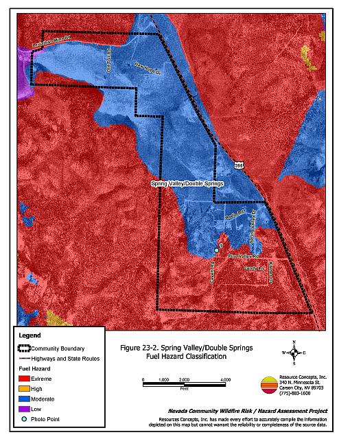
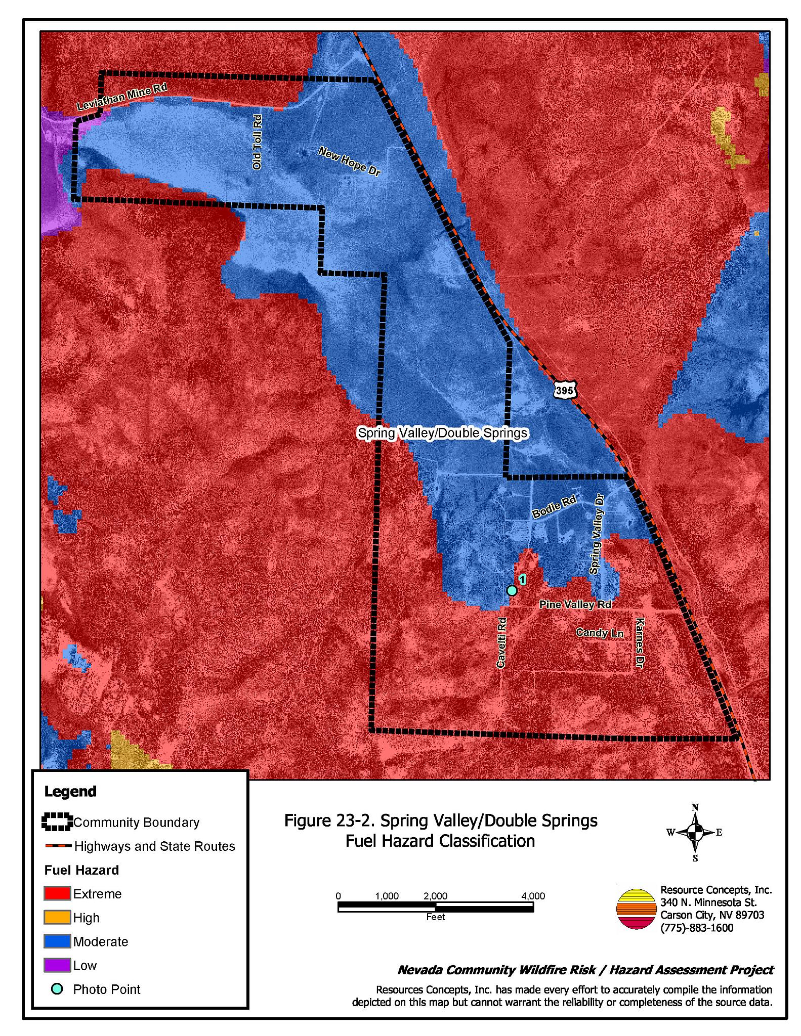
Vegetation, dead and down fuels, and topographic features contribute to the potential fire hazard around wildland-urban interface communities. The RCI Project Team mapped the fuel hazards and established fuel hazard photo points, which are detailed on Figures 23-2 and 23-3. The terrain in the northern portion of the community is generally flat with south and north facing slopes, north and south of the residences. The southern portion of the community is located on a gentle northeast-facing slope with steep (greater than thirty percent) slopes just west of the residences. The predominant winds are from the west and southwest. There is a significant history of large fires and fire ignitions near the community.
Three distinct fuel types occur in and around the community: pinyon/juniper woodland, sagebrush/bitterbrush, and meadow. At the time of the assessment, the area was suffering from prolonged drought stress, which has resulted in beetle infestations and a subsequent increase in fuel hazards. The dense pinyon pine and Utah juniper stands in the community were classified as a high to extreme fuel hazard. The sagebrush/bitterbrush vegetation type was considered a moderate to high fuel hazard, and the meadow vegetation was considered a low fuel hazard.
23.1.6 Previous Fire Hazard Reduction Projects
In 2004, the Nevada Fire Safe Council secured funding and implemented several projects in the Spring Valley/Double Springs community. Hand crews from the Great Basin Institute constructed a shaded fuelbreak on the west side of the community and an interior shaded fuelbreak by removing dead and diseased trees. Mechanical mastication equipment was used to remove shrubs and reduce tree density to approximately 25 trees per acre within a 150-foot wide strip along the west and south community boundaries and US Hwy 395. The mastication equipment was also used to remove shrubs, reduce tree density to approximately forty trees per acre, and remove limbs within 3.5 feet of the ground on remaining trees for a distance of 75 feet on each side of major roads in the community. Private landowners within the community treated approximately fifty acres to create defensible space around homes. In total, approximately 234 acres were treated and an estimated 1,315 tons of fuel were either removed from the community or masticated and left onsite.
In 2005, additional mechanical mastication treatment is scheduled to occur in the vicinity of homes in the northern portion of the community and along the private land portions of Leviathan Mine Road.
23.1.7 Fire Behavior and Worst Case Scenario
The RCI Project Team developed a worst-case scenario for Spring Valley/Double Springs. The worst-case scenario for a major wildland fire in the Spring Valley/Double Springs community would likely occur in the event of a fire starting south or west of the community on a high hazard day with a dry lightning storm causing multiple ignitions. Strong winds from the south or southwest, 25 mph or greater, could push a fire front northeast along the west side of US Highway 395 and into the homes interspersed with the dense sagebrush and pinyon/juniper fuels. Moderate to steep slopes on the south end of the community and high wind speed conditions could result in extreme fire behavior. A fire under these conditions could threaten homes and lives. The scenario would be worse if East Fork Fire and Paramedic Districts resources were unavailable due to assignment to a previous emergency situation elsewhere.
23.1.8 Ignition Risk Assessment
The RCI Project Team completed a risk assessment for Spring Valley/Double Springs and assigned the community a high ignition risk rating. A significant history of wildfire and fire ignitions exists in the public and Indian Trust lands surrounding the community. High ignition rates are likely due to the high fuel loads in and around the community, the tendency for lightning storms during the summer, and the number of people using the wildlands near Spring Valley/Double Springs.
23.2 SWCA Risk and Hazard Reduction Recommendations
The Spring Valley/Double Springs risk and hazard reduction recommendations focus on improving defensible space and promoting homeowner responsibilities. Other recommendations pertain to community coordination efforts that could be initiated to enhance the fire safe nature of the Spring Valley/Double Springs community. SWCA recommendations and additional recommendations developed by the RCI Project Team are detailed below.
23.2.1 Defensible Space
Property Owner Recommendations
Implement defensible space according to the vegetation type surrounding the structure.
- Pinyon/juniper: 100 feet of defensible space with additional fuel reduction for fifty feet beyond the defensible space distance.
- Sagebrush/bitterbrush: 100-foot defensible space distance for slopes less than twenty percent and 200-foot distance for slopes greater than twenty percent.
- Meadow: 30-foot defensible space distance on all slopes.
23.2.2 Fire Suppression Capabilities
Proper maintenance, storage, and acquisition of fire suppression equipment, along with regular and appropriate firefighter training and development of water drafting sources increases the fire suppression capability for those areas where fire protection is available.
Douglas County and East Fork Fire and Paramedic District Recommendations
- Form a new Volunteer Fire Department to provide fire suppression training to residents of Spring Valley/Double Springs. Obtain at a minimum, one Type III engine for fire suppression activities.
Property Owner and Spring Valley/Double Springs Chapter Nevada Fire Safe Council Recommendations
- Cooperate with the EFFPD and Nevada Division of Forestry to form an additional Volunteer Fire Department of the East Fork Fire and Paramedic Districts in the Spring Valley/Double Springs community.
- Clearly identify all streets with reflective signs and four-inch letters. Clearly mark all residences with the appropriate address signage.
- Install information kiosks at the entrances to the community that provide information regarding: propane tank locations, maps of the community, helibases, water sources, home locations, people needing evacuation assistance, utility types and locations, and types, numbers, and locations of livestock in the community.
- Invest in adequate amounts of barrier foam/gel that can be sprayed on the house prior to evacuation.
23.2.3 Fuel Reduction Treatments
Property Owner, Spring Valley/Double Springs Chapter Nevada Fire Safe Council, and East Fork Fire and Paramedic Districts Recommendations
- Widen the shaded fuelbreak located at the west, south, and southeast end of the community to a minimum width of 600 feet.
Utility Company Recommendation
- Remove trees or trim any tree branches within fifteen feet of either side of power lines and power poles throughout the Spring Valley/Double Springs community.
Property Owner and Douglas County Recommendations
Construct shaded fuelbreaks by thinning trees, limbing residual trees, and reducing understory vegetation in the locations indicated in Figure 23-1 according to the specifications listed below.
- Construct and maintain a 300-ft wide and 1,500-ft long shaded fuelbreak on the north side of homes on Leviathan Mine Road.
- Reduce fuels to a lesser degree on all individual parcels within the plan area.
- Resurface roads within the community with an aggregate or paved and widened to 24 feet, especially Calveti Road.
23.2.4 Community Coordination
Many of the most effective activities aimed at reducing the threat of wildfire for the Spring Valley/Double Springs community require that individual property owners coordinate with each other and with local fire authorities. Defensible space, for example, is more effective in small communities when applied uniformly throughout entire neighborhoods. Public education and awareness, neighbors helping neighbors, and proactive individuals setting examples for others to follow are just a few of the approaches that will be necessary to meet the fire safe goals in the community. Disposal of biomass generated from defensible space and fuel reduction treatments can sometimes be most efficiently handled through community programs, such as those initiated by the local Nevada Fire Safe Council chapter.
Property Owner Recommendation
- Read and become fully knowledgeable of evacuation procedures, fire safety zones, and safety procedures for sheltering in place in the event that evacuation is not possible.
East Fork Fire and Paramedic District Recommendation
- Prepare and distribute copies of a Spring Valley/Double Springs emergency evacuation plan to all residents. Conduct public workshops annually, prior to the fire season, to assure that all residents are fully knowledgeable of evacuation routes, evacuation procedures, designated fire safe zones, and procedures for sheltering in place in case evacuation becomes infeasible during a fast moving fire storm. Post evacuation information on a sign or with the SWCA proposed information kiosks either along Spring Valley Drive near the intersection with US Hwy 395 or other entrances to the community.
East Fork Fire and Paramedic Districts Recommendation
- Increase wildfire issue awareness through community newsletters, publications, meetings, and workshops, as well as through the UNR Cooperative Extension publication “Living With Fire.”
23.2.5 Defensible Space
Property Owner Recommendation
- Replace non-rated or Class C roofing materials with Class B or better materials.
23.3 Summary of Recommendations
| Involved Party | Recommended Treatment | Recommendation Description |
|---|---|---|
| Property Owners Nevada Fire Safe Council |
Defensible Space | Remove, reduce, and replace vegetation around homes to create adequate defensible space. Post addresses visible from the road on all homes within the community. |
| Construction Materials | Replace non-rated or Class C roofing materials with Class B or better materials. | |
| Community Coordination | Read and become fully knowledgeable of evacuation procedures, fire safety zones, and safety procedures for sheltering in place. Install information kiosks at the entrances to the community that provide information pertaining to wildfire safety in the community. |
|
| Fire Suppression Capability | Coordinate with the EFFPD and Sierra Forest Fire Protection district to form a new Volunteer Fire Department in the community. Consider purchasing a fire retardant gel or foam product designed for homeowner use. |
|
| Fuels Reduction | Cooperate with EFFPD and Sierra Forest Fire Protection District to widen the shaded fuelbreak at the south end of the community to 600 feet. | |
| Property Owners East Fork Fire and Paramedic Districts |
Fuels Reduction | Construct and maintain shaded fuelbreaks by thinning trees, limbing-up residual trees, and reducing understory vegetation in the locations indicated in Figure 23-1. |
| East Fork Fire and Paramedic Districts | Public Education | Increase wildfire issue awareness through community newsletters, publications, meetings, and workshops, as well as through the UNR Cooperative Extension publication “Living With Fire.” |
| Fuels Reduction | Widen the shaded fuelbreak installed at the south end of the community to a minimum width of 600 feet. | |
| Fire Suppression Capability | Form a new Volunteer Fire Department in the Spring Valley/Double Spring Community. Obtain at a minimum one Type III engine to station in the community and provide training to new VFD members. |
|
| Community Coordination | Complete and distribute copies of a Spring Valley/Double Springs emergency evacuation plan to all residents. Conduct public workshops annually to assure that all residents are knowledgeable of evacuation routes and procedures, designated fire safe zones, and procedures for sheltering in place. Post evacuation information on a sign along Spring Valley Drive near the intersection with US Hwy 395. |
|
| Utility Company | Fuels Reduction | Remove trees or trim any tree branches within fifteen feet of either side of power lines and power poles throughout the Spring Valley/Double Springs community. |
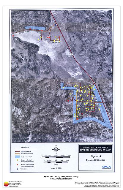
Figure 23-1Spring Valley/Double Springs SWCA Proposed Mitigation |
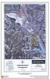 |
Figure 23-2Spring Valley/Double Springs Fuel Hazard Classification |
 |
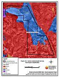
Spring Valley/Double Springs Fuel Hazard Photo Points

Photo Point 1. Spring Valley/Double Springs Fuel Hazard Photo Point. 4294874N, 0274565E, 40°NE. Vegetation in the extreme hazard areas of the community is dominated by pinyon pine. In the moderate hazard areas of the community, the vegetation is dominated by big sagebrush and bitterbrush.