![]()
![]()
16.0 Job’s Peak Ranch
16.1 Blackbull Wildfire Services Hazard and Risk Assessment
In 2004, Blackbull Wildfire Services completed an assessment entitled “Community Wildfire Threat Reduction and Project Implementation Plan for Job’s Peak Ranch, September 2004,” on behalf of the Nevada Fire Safe Council. The pertinent information for this report is summarized from the Blackbull Job’s Peak Ranch assessment.
The Job’s Peak Ranch community is located 4.5 miles southwest of Minden, Nevada along State Route 206 (Foothill Road). The community is situated west of Foothill Road on the east-facing alluvial fan, at the base of Job’s Peak. The 1,080-acre Ranch was subdivided into 122 parcels between two and seventeen acres in size. At the time of the assessment, 31 parcels were developed or in the process of being developed, with another 87 parcels sold. Sale of a new phase of parcels is scheduled for the spring of 2005. The assessment resulted in classifying the Job’s Peak Ranch community in the High Hazard category. The primary hazard factor for the Job’s Peak Ranch was the high hazard vegetation in close proximity to homes.
16.1.1 Community Design
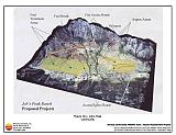
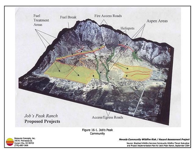
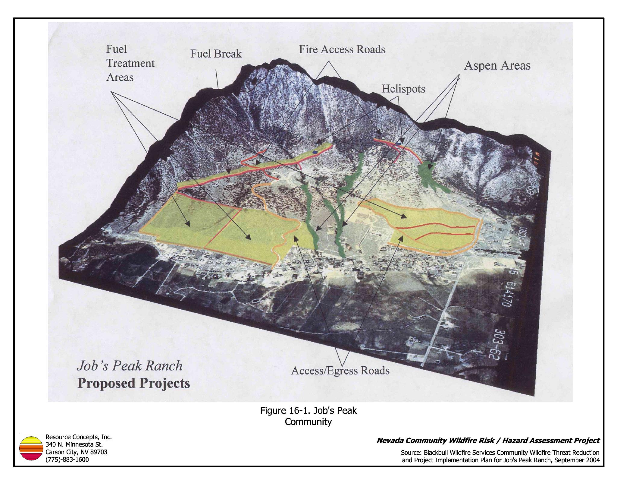
The Job’s Peak Ranch interface area is characterized as the intermix wildland-urban interface condition. Structures are scattered throughout the wildland area with no clear line of demarcation between wildland fuels and residences in the community (Figure 16-1).
- Roads: Five Creeks Road is the only access road to the community from Foothill Road. This road is paved, has a grade greater than five percent and is between 20 and 24 feet in width.
- Signage: Street signs were not present and visible along all streets in the subdivision. Clear and visible residential addresses and street signs are important to aid firefighting personnel in locating homes during low visibility conditions that occur during a wildland fire.
- Utilities: Electrical utilities are underground. Above ground propane tanks were noted in the community with flammable wood structures built around propane tanks to hide them.
16.1.2 Construction Materials
A great majority of the homes in the community were built with Class A fire-resistant roofing materials and a majority of homes observed had unenclosed balconies, porches, decks, or other architectural features that create drafts and provide areas where sparks and firebrands can be trapped, smolder, ignite, and rapidly spread fire to the home.
16.1.3 Defensible Space
A majority of the homes assessed had between thirty and seventy feet of vegetative clearance around the home. In Job’s Peak Ranch the recommended minimum defensible space distance ranges between 100 and 200 feet depending upon slope.
16.1.4 Suppression Capabilities
Wildfire Protection Resources
The Sheridan Volunteer Fire Department (Station 8) and the Nevada Division of Forestry Sierra Forest Fire Protection District are responsible for wildfire and structure fire protection in Job’s Peak Ranch. The VFD Station is within five miles of the community. See Tables 4-2 and 4-3 for more information on the typical fire suppression response for first-alarm wildland-urban interface fires in Douglas County. Appendix E lists the type and number of fire suppression vehicles located at each EFFPD and Douglas County VFD station.
Water Sources and Infrastructure
Fire hydrants (500 gpm) are available and spaced less than 1,000 feet apart in the Job’s Peak Ranch community. Several creeks within the community flow year round and are available water drafting sources.
Community Preparedness
The Job’s Peak Ranch community formed a local chapter of the Nevada Fire Safe Council in August of 2003. There is currently no evacuation plan for residents of the community, nor is there information on safe zones within the community in the emergency and disaster plans.
16.1.5 Factors Affecting Fire Behavior
The terrain is very steep in and around the Job’s Peak Ranch community. Slopes range between ten and twenty percent within community and increase to greater than sixty percent just west of the community. The predominant wind direction is downslope from the south and southwest. There is a significant history of large fires and fire ignitions near the community.
Three main vegetation types were identified in the Job’s Peak Ranch community including sagebrush/bitterbrush, cheatgrass, and mixed conifer. The sagebrush/bitterbrush and cheatgrass types were considered high fuel hazards and the mixed conifer was considered a medium/high hazard fuel type. Aspen groves were located along the creeks throughout the community.
16.1.6 Fire Behavior Worst Case Scenario
The worst-case scenario for Job’s Peak Ranch would likely occur in the event of a dry-lightning storm in which several ignitions occurred on the mountain southwest or west of the community. Driven by 25 mile per hour winds any fire ignition could result in a crown fire capable of rapidly spreading downhill toward the community. Very few roads provide access for fire suppression equipment south and west of the community, which decreases response time. Spot fires could result in multiple fire fronts near residences in the community and could increase the difficulty for fire suppression personnel protecting homes. If either Five Creeks Road or Foothill Road were to be closed in two places due to fire, homeowner evacuation and fire suppression response could be limited.
16.1.7 Ignition Risk Assessment
Blackbull Wildfire Services assigned Job’s Peak Ranch an ignition risk rating of medium frequency/medium impact for a fire ignition occurring within the community. A rating of medium frequency/medium impact was given for a fire starting near Foothill Road and burning uphill toward the community. A low frequency/high impact rating was giving to an ignition starting west of the community. The RCI Project Team classified the community with a high ignition risk.
16.2 Risk and Hazard Reduction Recommendations
The Job’s Peak Ranch risk and hazard reduction recommendations were developed by Blackbull Wildfire Services and reviewed by the RCI Project Team. The recommendations that the Fire Specialist on the RCI Project Team concurred with are listed below. Refer to Blackbull 2004b for more information.
16.2.1 Fire Suppression Capabilities
Improving or creating community access improves safety of egress for residents and access for firefighters.
East Fork Fire and Paramedic Districts and Nevada Division of Forestry Recommendation
- Develop a pre-attack plan for the Job’s Peak Ranch community. The plan should include information regarding the location of water sources, helibases, resident safety zones, and other fire protection facility information.
16.2.2 Community Coordination
Many of the most effective activities aimed at reducing the threat of wildfire for the Job’s Peak Ranch community require that individual property owners coordinate with each other and local fire authorities as they have through the Job’s Peak Ranch Chapter of the Nevada Fire Safe Council. Public education and awareness, neighbors helping neighbors, and proactive individuals setting examples for others to follow are just a few of the approaches that will be necessary to meet the fire safe goals in the community. Disposal of biomass generated from defensible space and fuel reduction treatments can sometimes be most efficiently handled through community programs.
East Fork Fire and Paramedic Districts and Nevada Division of Forestry Recommendation
- Develop a community fire notification and evacuation plan for the Job’s Peak Ranch community. The plan should address evacuation procedures, safety zones, and information on sheltering in place.
East Fork Fire and Paramedic Districts, Nevada Division of Forestry, and Job’s Peak Ranch Fire Safe Council Recommendation
- Initiate a community-wide fire safe program to enhance property owner awareness and knowledge about wildfires and associated risks of living in a fire prone environment.
Douglas County Recommendation
- Adopt a county ordinance regarding fuel reduction and defensible space requirements for wildland-urban interface areas. Require defensible space implementation on all developed and undeveloped lots within interface areas. If landowners do not complete defensible space treatments within a specified time frame, authorize EFFPD to charge the landowner for defensible space services through property tax levies. Require fuel reduction treatments prior to approval of new wildland-urban interface subdivisions and require approval of defensible space implementation prior to issuing building permits.
16.2.3 Fuel Reduction Treatments
Construct fuelbreaks and fuel reduction treatments by thinning trees, limbing residual trees, and reducing understory vegetation and brush density in the locations indicated in Figure 16-2. These specifications are included in the fuel reduction treatment fact sheet in Appendix D. When constructing fuelbreaks, all dead woody material should be hand or machine piled. Maintain all fuel reduction treatments listed below on a three to seven year cycle depending upon vegetative regrowth.
East Fork Fire and Paramedic Districts, Nevada Division of Forestry, and Property Owner Recommendations
- Fuelbreak 1: Improve current fuelbreak behind homes on Foothill Road to a minimum width of 100 feet (approximately ten acres).
- Fuelbreak 2: Construct a fuelbreak on both sides of Five Creek Road from the main gate to the property 20 and Buffalo Creek Ranch. The fuelbreak should be a minimum of fifty feet on both sides of the road (approximately seven acres).
- Fuelbreak 3: Construct a 400-foot wide fuelbreak west of properties 42, 22, and 38 and have it tie into the fuelbreak recommended for the Sheridan Acres and North Foothill Road Corridor communities (approximately 180 acres).
- Fuel Reduction Treatment 1: Reduce sagebrush and bitterbrush density to a spacing equal to twice the height of the shrubs. Hand cut, pile, and burn or mechanically masticate vegetation in the treatment areas. Complete treatments southeast of the planned development area.
- Fuel Reduction Treatment 2: Reduce sagebrush and bitterbrush density to a spacing equal to twice the height of the shrubs. Mechanically pile ground fuels throughout the treatment area. The recommended treatment width is 300 feet and should be constructed from the west side of properties 38 through 42, from the north edge of Sheridan Creek to Stutler Canyon (estimated 18 acres).
- Proposed Fuel Treatment 3: Reduce sagebrush and bitterbrush density following “Living With Fire” specifications. Mechanically pile down wood materials throughŁout the treatment area west of the current development to Nevada-California state line, from the south end of Barber Creek to the south end of the Job’s Peak Ranch property (estimated 33 acres).
- Maintain existing fuelbreaks within the community every three to seven years as needed to maintain reduced fuel conditions.
16.3 Summary of Recommendations
| Involved Party | Recommended Treatment | Recommendation Description |
|---|---|---|
| Property Owners | Fuels Reduction | Coordinate with EFFPD and NDF to construct recommended fuelbreaks and fuel reduction projects. |
| Nevada Fire Safe Council Local Chapter | Community Coordination | Coordinate with EFFPD and NDF to initiate a community-wide fire safe program to enhance property owner awareness and knowledge about wildfires and associated risks of living in a fire prone environment. |
| Douglas County | Community Coordination | Create a county ordinance to include provisions requiring fuel reduction treatments on undeveloped lots prior to new wildland-urban interface subdivision approval and defensible space implementation on each lot prior to building permit issuance. |
| East Fork Fire and Paramedic Districts Nevada Division of Forestry |
Fire Suppression Capability | Develop a pre-attack plan for the Job’s Peak Ranch community. |
| Fuels Reduction | Construct three proposed fuelbreaks and three proposed fuel reduction treatments. | |
| Community Coordination | Develop a community fire notification and evacuation plan for the Job’s Peak Ranch community. Initiate a community-wide fire safe program to enhance property owner awareness and knowledge about wildfires and the associated risks of living in a fire prone environment. |
Figure 16-1Job’s Peak Community |
 |