![]()
![]()
14.0 Holbrook Junction
14.1 RCI Hazard and Risk Assessment
In 2003, Resource Concepts, Inc. completed an assessment entitled “Community Fire Safe Plan for the Holbrook Junction Community Douglas County, Nevada,” on behalf of the Nevada Fire Safe Council. The pertinent information for this report is summarized from the RCI Holbrook Junction assessment.
The Holbrook Junction Community is located at Holbrook Junction where US Highway 395 intersects State Route 208, approximately sixteen miles south of Gardnerville, Nevada and two miles north of Topaz Lake. Much of the area surrounding the community is public land administered by the US Forest Service, Bureau of Land Management, and Bureau of Indian Affairs 99-year leases held in trust by the Washoe Tribe of Nevada and California. Approximately fifty residences were evaluated when the risk and hazard assessment was conducted for Holbrook Junction. The assessment resulted in classifying the Holbrook Junction community in the High Hazard category (adapted from RCI 2003). The primary hazard factors for the Holbrook Junction area were limited address signage on some residences and limited implementation of defensible space throughout the community.
14.1.1 Community Design
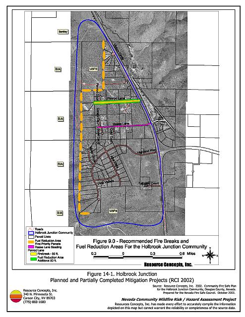
The Holbrook Junction interface area is characterized by the intermix wildland-urban interface condition. Structures are scattered throughout the wildland area with no clear line of demarcation between wildland fuels and residences in the community. A majority of the homes assessed were on parcels between 2.5 and ten acres with the exception of a small trailer park (see Figure 14-1).
- Roads: US Highway 395 and State Route 208 are the primary roads connecting the Holbrook Junction community with other communities in Douglas County. US Highway 395 and State Route 208 are paved and at least 24 feet wide, an adequate width for two-vehicle passage and a fire suppression equipment maneuverability. Penrod Lane, Reese Road, and Highland Way are the primary entrance and exit routes for the community. The roads in the community are either gravel or paved and range between eighteen and thirty feet in width. Several of the secondary roads terminate in dead ends or small cul-de-sacs and do not provide adequate turn around space for fire suppression vehicles. Many driveways are very narrow and do not provide adequate room for fire suppression vehicles to maneuver.
- Signage: Street signs were present and visible along all streets in the Holbrook Junction community. Residential addresses were visible on a majority of homes surveyed; however, many of the addresses were small and painted on wooden signs that would be difficult to see during smoky conditions. Clear and visible residential addresses and street signs are important to aid firefighting personnel in locating homes during low visibility conditions that may occur during a wildland fire.
- Utilities: All utilities were noted to be above ground. Improper maintenance of power line corridors and vegetation clearance around propane tanks was observed in some parts of the community. Reducing vegetation underneath and adjacent to power lines minimizes the possibility of power lines producing sparks during windstorms and starting fires in nearby vegetation.
14.1.2 Construction Materials
A great majority of the homes in the community were built with fire-resistant roofing materials such as composition roofing, metal, or tile. Most of the homes observed had Class C wood siding materials (burns in less than twenty minutes). Less than twenty percent of homes observed had unenclosed balconies, porches, decks or other architectural features that create drafts and provide areas where sparks and firebrands can be trapped, smolder, ignite, and rapidly spread fire to the home.
14.1.3 Defensible Space
Approximately 25 percent of the homes assessed had landscaping that meets the minimum defensible space requirement to help protect the home from damage or loss during a wildfire. In Holbrook Junction the recommended minimum defensible space distance ranged between 100 and 200 feet depending upon slope.
14.1.4 Suppression Capabilities
Wildfire Protection Resources
Both the East Fork Fire and Paramedic Districts Topaz Ranch Estates Volunteer Fire Department Station 4 (a combination career/volunteer station with two career members) and the Topaz Lake Volunteer Fire Department Station 5 provide wildland and structure fire protection to Holbrook Junction. The Topaz Ranch Estates VFD responded to 213 emergency calls in 2001. Station 4 actively conducts “Compost your Combustibles” and reflective address sign programs (East Fork Fire and Paramedic Districts website). See Tables 4-2 and 4-3 for more information on the typical fire suppression response for first-alarm wildland-urban interface fires in Douglas County. Appendix E lists the type and number of fire suppression vehicles located at each EFFPD and Douglas County VFD station.
The Interagency wildland fire resources will also respond to all wildland fire reports within the vicinity of the Holbrook Junction community. The response will be initiated by the Sierra Front Interagency Dispatch Center.
Water Sources and Infrastructure
Water availability for fire suppression in Holbrook Junction includes two, static 50,000-gallon tanks: one near the junction of US Highway 395 and Leviathan Mine Road in the Spring Valley/Double Springs community (five miles north), and the other near Penrod Lane in the Holbrook Junction Community. The tanks are not connected to wells and must be filled each fire season. No fire hydrants are available in the Holbrook Junction community. Two tanks on wells are also located in Topaz Ranch Estates including one 210,000-gallon tank and one 660,000-gallon tank (three miles east). Hydrants are also available at Topaz Lodge, approximately three miles south of Holbrook Junction. Topaz Lake may be used as a helicopter dip site and drafting source (approximately six mile round trip).
Community Preparedness
The Holbrook Junction community formed a local chapter of the Nevada Fire Safe Council in October of 2003. There is currently no evacuation plan for residents of the community, nor do the emergency and disaster plans provide information on safe zones within the community.
14.1.5 Factors Affecting Fire Behavior
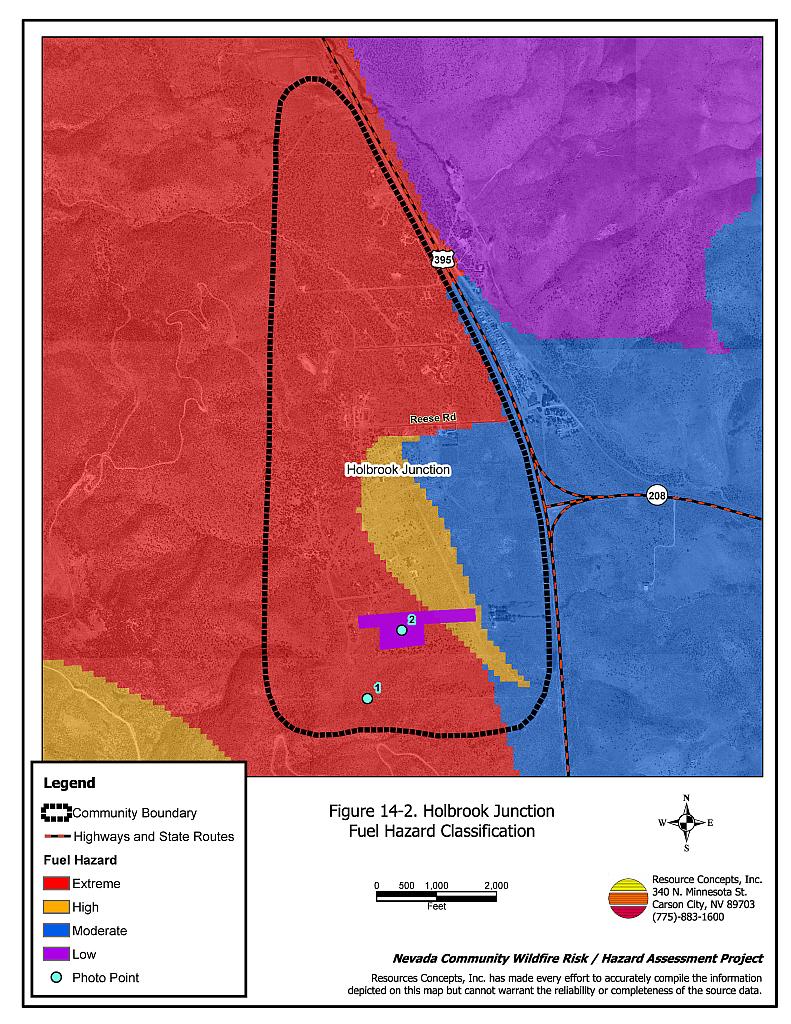
Vegetation, dead and down fuels, and topographic features contribute to the potential fire hazard around wildland-urban interface communities. The fuel hazards were mapped for Holbrook Junction and fuel hazard photos were taken to provide additional information for the vegetation type descriptions (see Figures 14-2 and 14-3).
The majority of the terrain is gently sloping (less than eight percent slope) with steeper slopes greater than twenty percent on the west side of the community. The predominant winds are from the west and southwest, and downslope winds are common, especially in the late afternoon during the summer months. Numerous fires have occurred within the vicinity of the community from both human and lightning causes. The 9,283-acre Gate Complex Fire occurred south of the community in 2002. A 7,443-acre fire occurred northeast of the community in 1996 and a 307-acre fire and the sixteen-acre Wildoat Fire occurred east of the community in 1994. Numerous other fires have occurred south of the community between 1950 and 1975.
The predominant vegetation in the community is characterized by a pinyon pine overstory with an understory of big sagebrush, bitterbrush, needlegrass, bottlebrush squirreltail, cheatgrass, and various forbs. The pinyon pines were generally twenty feet in height with tree canopies spaced less than ten feet apart. The pinyon pine woodlands were considered a high to extreme fuel hazard. In the southeast portion of the community, sagebrush and crested wheatgrass are the dominant species. In this area of the community the fuel hazard was considered moderate.
14.1.6 Previous Fire Hazard Reduction Projects
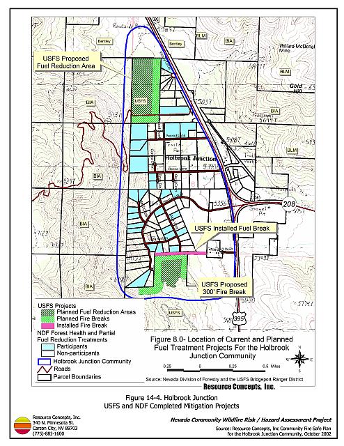
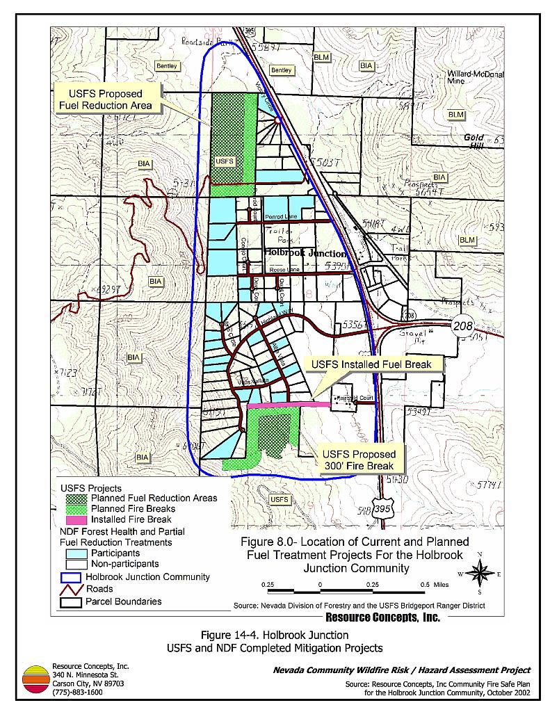
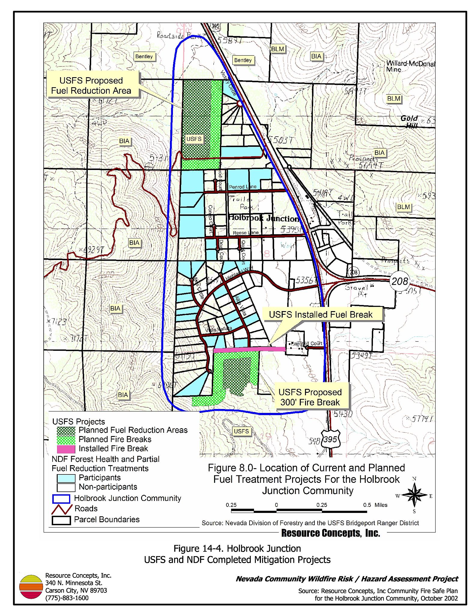
Several fuel reduction projects have been conducted within and adjacent to the Holbrook Junction community (Figure 14-4). The US Forest Service has installed a fifty to 100-foot wide firebreak adjacent to a 900-foot wide shaded fuelbreak on National Forest lands abutting the south side of the community. The trees and shrubs were removed using mechanical mastication equipment. The Forest Service also installed a 300-foot wide fuelbreak along the north perimeter of the community and two fuel treatment areas where trees were thinned to a spacing of thirty feet between canopies.
Projects funded through the Nevada Division of Forestry Forest Stewardship Program and the Stewardship Incentive Cost-Share Program in the Holbrook Junction community in 2002 treated 27 parcels for defensible space to varying degrees depending upon homeowner preference. The treatments included thinning, removing lower limbs of trees, diseased trees, shrubs, and other ladder fuels.
In 2004, a Nevada Division of Forestry grant provided funding to complete the first half of a shaded fuelbreak on the west side of the Holbrook Junction community (10.5 acres). A Great Basin Institute hand crew constructed the shaded fuelbreak by thinning trees to approximately 40 trees per acre and hand grubbing about 60 percent of the brush for a width of 150 feet. Slash from the fuel reduction was chipped onsite and transported to the Spring Valley/Double Springs community fuels disposal site.
The Bureau of Land Management has provided funding to finish the west side shaded fuelbreak in the fall of 2005. The US Forest Service has given permission for temporary slash disposal on a parcel adjacent to the community. Other planned treatments for 2005 include additional fuel reduction along interior roads and adjacent to US Hwy 395.
14.1.7 Fire Behavior and Worst Case Scenario
The worst-case scenario for a wildland fire in the Holbrook Junction community would involve a wind-driven wildland fire ignited south of the community on the east-facing slope. If the fire were to occur in the mid-afternoon on a high hazard day with south or southwest winds in excess of 25 miles per hour, the fire would likely burn northward and quickly threaten residences in the community. Due to the high fuel loads and fuel bed continuity, extreme fire behavior could be exhibited under high wind speed conditions. The scenario would be worse if East Fork Fire and Paramedic Districts resources were unavailable due to assignment to an emergency situation elsewhere.
14.1.8 Ignition Risk Assessment
Holbrook Junction has a high ignition risk rating. A significant history of wildfire and fire ignitions exists in the public lands and private lands surrounding the community. High ignition rates are likely due to the high fuel loads in and around the community, the tendency for lightning storms during the summer, and the number of people using the wildlands near Holbrook Junction.
14.2 Risk and Hazard Reduction Recommendations
The Holbrook Junction risk and hazard reduction recommendations focus on improving defensible space and promoting homeowner responsibilities. Other recommendations pertain to community coordination efforts that could be initiated to enhance the fire safe nature of the Holbrook Junction community. Recommendations are detailed below.
14.2.1 Defensible Space
Property Owner Recommendations
Implement defensible space according to the vegetation type surrounding the structure. Refer to Appendix D for specific defensible space recommendations.
- Homes within the extreme hazard areas should be treated with a minimum defensible space distance of 30-feet with an additional fuel reduction treatment area of 120 feet extending beyond the 30-foot distance.
- Homes within the moderate hazard areas should install a minimum 30-foot defensible space distance around homes with an additional 100-foot treatment area of brush thinning.
14.2.2 Fire Suppression Capabilities
Proper maintenance, storage, and acquisition of fire suppression equipment along with regular and appropriate firefighter training increases fire suppression capability for those areas where fire protection is available.
East Fork Fire and Paramedic Districts Recommendation
- Coordinate with the Nevada Division of Forestry to seasonally station an additional wildfire engine and crew at Station #4 (Topaz Ranch Estates VFD).
Property Owner Recommendation
- Coordinate with the Nevada Fire Safe Council and the UNR Cooperative Extension Service to encourage homeowners to retrofit their driveways and create adequate turnarounds or horseshoe driveways to improve access for firefighting equipment. This includes reinforcing all driveway culverts that do not currently support the weight of the Type I fire engines.
Douglas County Roads Department Recommendation
- Coordinate with the affected landowners to construct the approved road (Shelby Lane) between Reese and Penrod Lanes to improve emergency evacuation and firefighter access.
14.2.3 Fuel Reduction Treatments
Fuel reduction treatments are applied on a larger scale than defensible space treatments. By permanently changing the fuel structure over large blocks of land to one of a lower volume or reduced flammability (a fuel reduction treatment), the expected result in the event of a catastrophic wildfire would be one of reduced capacity for uncontrolled spread through the treatment area. Construct shaded fuelbreaks in the locations indicated in Figure 14-2 according to the specifications listed below.
Property Owner Recommendations
- Construct and maintain a 200-foot wide shaded fuelbreak for the length of Penrod Lane. Cut all pinyon trees within fifty feet of both sides of the road, and thin trees to a canopy spacing of one and one-half (1-1/2) times the height of the trees for an additional fifty feet on each side of the road. Thin all shrubs in the fuelbreak area such that canopies are spaced by a distance two times the height of the shrubs.
- Reduce tree and shrub densities on all private land parcels forming the north and west boundaries of the community. Thin trees to a minimum canopy spacing distance of 1-1/2 times the height of the trees.
- Remove shrubs and other vegetative fuels within thirty feet of each side of Reese Lane and plant the area with crested wheatgrass.
- Remove all trees within a minimum distance of thirty feet of each side of the driveway. Reduce shrub density within 100 feet of each side of private driveways within the community.
- Construct and maintain a 100-foot wide shaded fuelbreak around the perimeter of the trailer park. Prune branches of remaining trees to a minimum height of four feet above ground.
Nevada Fire Safe Council and Bureau of Land Management Recommendation
- Complete construction of the 150-foot wide shaded fuelbreak by the fall of 2005.
Douglas County Recommendation
- Coordinate with Douglas County to revise annual road maintenance plans to include removal and thinning of overhanging vegetation within county road right-of-ways to meet the specifications in the Fire Safe Plan (RCI 2003).
Utility Company Recommendation
- Continue clearing all trees underneath and adjacent to overhead power lines and poles. This includes the poles and lines to individual parcels. Trees that can touch or blow into the power lines create a hazard that can easily be removed and maintained.
14.2.4 Community Coordination
Many of the most effective activities aimed at reducing the threat of wildfire for the Holbrook community require that individual property owners coordinate with each other and with local fire authorities. Address signage and defensible space, for example, are more effective in communities when applied uniformly throughout entire neighborhoods. Public education and awareness, neighbors helping neighbors, and proactive individuals setting examples for others to follow are just a few of the approaches that will be necessary to meet the fire safe goals in the community. Disposal of biomass generated from defensible space and fuel reduction treatments can sometimes be most efficiently handled through community programs.
Property Owner and East Fork Fire and Paramedic Districts Recommendations
- Increase wildfire issue awareness through distribution of the Holbrook Junction Community Fire Safe Plan, community newsletters, publications, and public awareness meetings.
- Initiate a local community and VFD project to install roadside metal address signs with four-inch reflective lettering at all residences to assist emergency responders in locating residences.
14.3 Summary of Recommendations
| Involved Party | Recommended Treatment | Recommendation Description |
|---|---|---|
| Property Owners | Defensible Space | Remove, reduce, and replace vegetation around homes to create defensible space. |
| Fire Suppression Capability | Retrofit driveways and create adequate turnarounds or horseshoe driveways to improve access for firefighting equipment. | |
| Fuels Reduction | Remove all trees within a minimum distance of thirty feet of each side of the driveway. Reduce fuels within 100 feet of each side of private driveways within the community. Coordinate with the local fire suppression agencies to install proposed fuel reduction treatments. |
|
| Community Coordination | Post addresses that are clearly visible from the road on all homes within the community. Increase wildfire issue awareness through distribution of the Holbrook Junction Community Fire Safe Plan, community newsletters, publications, and public awareness meetings. |
|
| Utility Company | Fuels Reduction | Remove pinyon and juniper trees within fifteen feet of either side of power lines and poles throughout the Holbrook Junction community. |
| East Fork Fire and Paramedic Districts | Fire Suppression Capability | Coordinate with the Nevada Division of Forestry to seasonally station an additional wildfire engine and crew at Station #4 (Topaz Ranch Estates VFD). |
| Nevada Fire Safe Council BLM |
Fuels Reduction | Complete construction of the 150-foot wide shaded fuelbreak on the west side of the community. |
| Douglas County Roads Department | Fire Suppression Capability | Coordinate with the affected landowners to construct and maintain the approved road (Shelby Lane) between Reese and Penrod Lanes to improve emergency evacuation and firefighter access. |
| East Fork Fire and Paramedic Districts | Fuels Reduction | Coordinate with private landowners to construct and maintain shaded fuelbreaks and fuel reduction treatments throughout the community. Coordinate with Douglas County to revise annual road maintenance plans to include removal and thinning of overhanging vegetation within county road right-of-ways. |
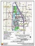
Figure 14-1Holbrook Junction Planned and Partially Completed Mitigation Projects (RCI 2002) |
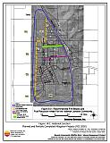 |
Figure 14-2Holbrook Junction Fuel Hazard Classification |
 |
Figure 14-3. Holbrook Junction Fuel Hazard Photo Points

Photo Point 1. Holbrook Junction Fuel Hazard Photo Point. 4288739N, 0276959E, 12°N. The extreme hazard pinyon pine/sagebrush/bitterbrush and moderate hazard sagebrush/crested wheatgrass vegetation types are the main fuel types identified in the Holbrook Junction community.
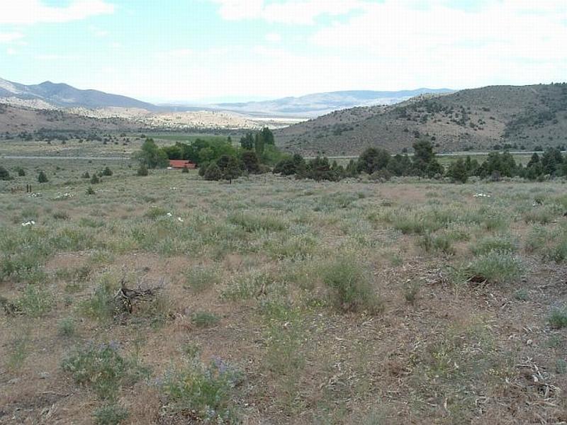
Photo Point 2. Holbrook Junction Fuel Hazard Photo Point. 4289084N, 0277140E, 90°E. South of the community, the US Forest Service has installed a 100-foot wide firebreak adjacent to a 900-foot wide shaded fuelbreak. The firebreak is dominated by lupine, bottlebrush squirreltail, and cheatgrass and was considered a low fuel hazard.
Figure 14-4Holbrook Junction USFS and NDF Completed Mitigation Projects |
 |