![]()
![]()
6.0 Bodie Flats
6.1 Hazard and Risk Assessment
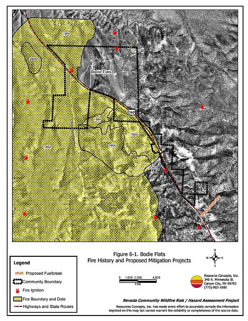
The Bodie Flats community is located along US Highway 395, approximately 4.5 miles south of Gardnerville Nevada. The community is situated primarily on the eastern side of the highway and includes the Pine View Estates subdivision. On the west side of the highway the area called Carter’s Station and approximately five homes on China Springs Road are also included in the community. The majority of the residences are located within the areas of Bodie Flat, Cedar Flat, and the canyon along US Highway 395. The major land ownership in the community consists of either private land or 99-year leases from the Washoe Tribe of Nevada and California. Approximately 160 residences were evaluated when the risk and hazard assessment was conducted for Bodie Flats. The assessment resulted in classifying the Bodie Flats community in the Extreme Hazard category (81 points). A summary of the factors that determine this hazard rating is included in Table 6-2. The primary hazard factors for the Bodie Flats area were limited signage on residences and residential streets, limited defensible space implementation, and high to extreme hazard fuels throughout a large portion of the community.
6.1.1 Community Design
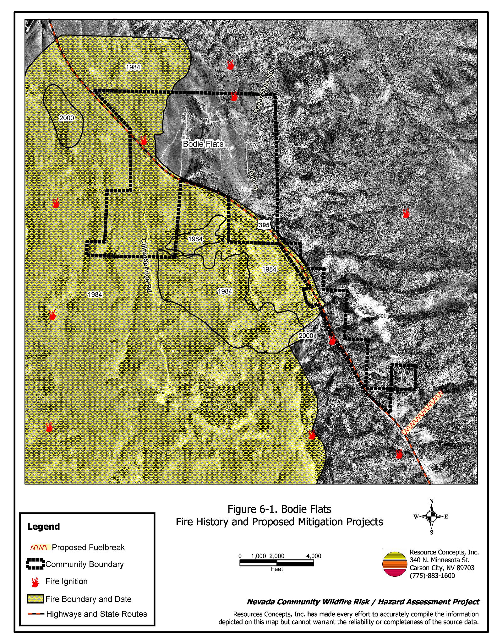
The Bodie Flats interface area is characterized as an intermix wildland-urban interface condition. Structures are scattered throughout the wildland area with no clear line of demarcation between wildland fuels and residences in the community. A majority of the homes assessed were on parcels of one acre or less and most structures are spaced close together (see Figure 6-1).
- Roads: US Highway 395 is the primary road connecting the Bodie Flats community with other communities in Douglas County. Jolie Street is the primary entrance to the Pine View Estates. Jolie Street and Courtland Lane are the primary entrance and exit routes for residences in the Bodie Flats and Cedar Flats areas and are at least 20 feet wide. US Highway 395 is paved and at least 24 feet wide, adequate width for two-vehicle passage and fire suppression equipment to maneuver. South of the Pine View Estates, dead-end roads and driveways may limit the ability for fire suppression equipment to maneuver or turn around.
- Signage: Street signs were present and visible along all streets in the Bodie Flats and Cedar Flat areas. A majority of street signs were either not present or not visible south of the Pine View Estates. Residential addresses were visible on approximately eighty percent of the homes surveyed. Clear and visible residential addresses and street signs are important to aid firefighting personnel in locating homes during low visibility conditions that may occur during a wildland fire.
- Utilities: All utilities were noted to be above ground. Some power line corridors and propane tanks are in need of vegetation clearance. Reducing vegetation underneath and adjacent to power lines minimizes the possibility of power lines producing sparks during windstorms and starting fires in nearby vegetation.
6.1.2 Construction Materials
A great majority of the homes in the community were built with fire-resistant siding and fire resistant composite roofing materials. Less than twenty percent of homes had unenclosed features such as porches, balconies, or decks that create drafts and provide areas where sparks and firebrands can be trapped, smolder, ignite, and rapidly spread fire to the home.
6.1.3 Defensible Space
Approximately fifteen percent of the homes assessed have landscaping that meets the minimum defensible space requirement to help protect the home from damage or loss during a wildfire. In Bodie Flats the recommended minimum defensible space distance ranged between 100 and 200 feet depending upon slope.
6.1.4 Suppression Capabilities
Wildfire Protection Resources
The Ruhenstroth Volunteer Fire Department (Station 10) of the East Fork Fire Protection District is responsible for wildfire and structure fire protection in Bodie Flats. At the time that interviews were conducted for this report the Ruhenstroth VFD reported eighteen members on its roster (East Fork Fire Protection District website). See Tables 4-2 and 4-3 for more information on the typical fire suppression response for first-alarm wildland-urban interface fires in Douglas County. Appendix E lists the type and number of fire suppression vehicles located at each EFFPD and Douglas County VFD station.
Because the Bodie Flats community is surrounded mostly by Indian allotment lands or public lands, the BLM/Interagency resources will respond to all wildland fire reports. The response will be initiated by the Sierra Front Interagency Dispatch Center.
Water Sources and Infrastructure
In the Pine View Estates subdivision, 500 gpm hydrants are available within 500 feet of structures. However, hydrants are not available in the rest of the Bodie Flats community, including the five residences on China Springs Road. The water system for Bodie Flats relies on a gravity system from a 120,000-gallon tank. The existing infrastructure for the water delivery system meets the 2000 Uniform Fire Code standards. Another nearby water source for Bodie Flats is a 50,000 gallon tank at Spring Valley/Double Springs, with a twenty minute turn-around distance.
6.1.5 Factors Affecting Fire Behavior
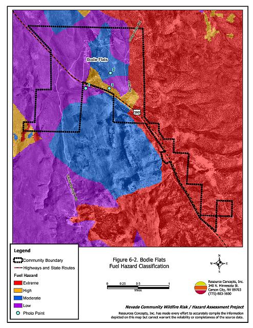
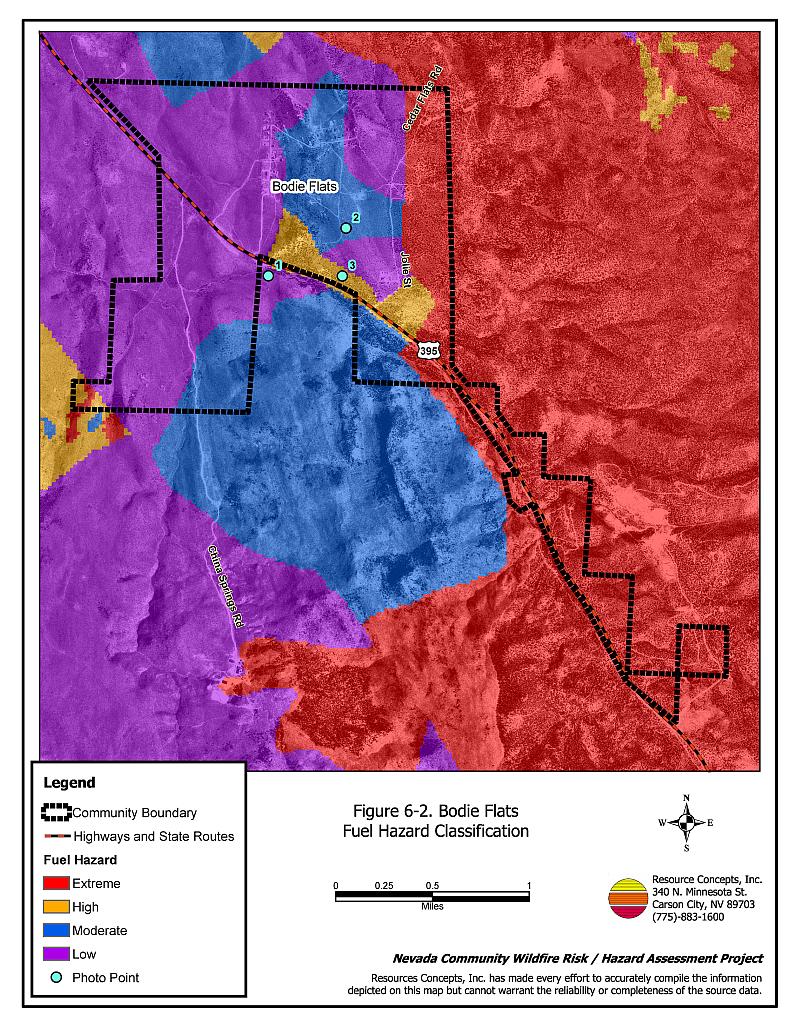
Vegetation, dead and down fuels, and topographic features contribute to the potential fire hazard around wildland-urban interface communities. The fuel hazards were mapped for Bodie Flats and fuel hazard photos were taken to provide additional information for the vegetation type descriptions (see Figures 6-2 and 6-3).
The terrain in the northern portion of the community is generally flat with south and west facing slopes located north and east of the residences. The southern portion of the community is predominantly located on a steep southwest-facing canyon slope. Slopes range from flat at the northern end of the community to greater than forty percent at the southern end. The predominant winds are from the south and southwest. There is a significant history of large fires and fire ignitions near the community.
The vegetative fuel density in the Bodie Flats community was generally classified as heavy with fuel loads ranging from one to ten tons per acre. The dominant vegetation types around Bodie Flats are sagebrush/perennial grass and pinyon/juniper. Fires in 1984 and 2000 burned the area southwest of the community and just into the north part of the community. Burned areas within the community are dominated by big sagebrush, Mormon tea, desert peach, rabbitbrush, and cheatgrass. The shrubs in these areas were one to two feet tall, widely spaced, and classified as a low fuel hazard.
In unburned areas the predominant vegetation was characterized by big sagebrush, Mormon tea, desert peach, currant, bitterbrush, rabbitbrush, and low sagebrush, with understory grass species including bottlebrush squirreltail, cheatgrass, basin wildrye, and Sandberg bluegrass. The density of the pinyon and juniper tree canopy varied from light to heavy. The fuel load was estimated between two and seven tons per acre. Where tree density is light, the fuel hazard was considered moderate and where the tree density was heavy, the fuel hazard was classified as extreme.
Vegetation in the southern portion of the community is similar to the unburned areas north of the community dominated by the same shrub, grass, and tree species. However as the elevation increases in the southern portion of the community the fuel density also increases. The fuel load ranged from five to ten tons per acre in this area and was classified as an extreme fuel hazard.
6.1.6 Fire Behavior and Worst Case Scenario
The worst-case scenario for a major wildland fire in the Bodie Flats community would likely occur in the event of a fire starting near the south end of the community on a high hazard day with a dry lightning storm causing several other ignitions. Combined with a 25 mph or greater south wind, a fire could be pushed northward along the east side of US Highway 395 and into the homes interspersed with the dense sagebrush and pinyon/juniper vegetation. Extreme fire behavior could be exhibited due to moderate to steep south-facing slopes and high wind speed conditions. A fire under these conditions could burn from the south all the way through the Bodie Flats community and continue northward where it would threaten homes and lives in the Ruhenstroth community. The scenario would be worse if East Fork Fire and Paramedic Districts resources were unavailable due to assignment to an emergency situation elsewhere.
6.1.7 Ignition Risk Assessment
Bodie Flats was given a high ignition risk rating due to high risks from lightning and power lines. A significant history of wildfire and fire ignitions exists on public lands and private lands surrounding the community. High ignition rates are likely due to the high fuel loads in and around the community, the tendency for lightning storms during the summer, and the number of people using the wildlands near Bodie Flats.
6.2 Risk and Hazard Reduction Recommendations
The Bodie Flats risk and hazard reduction recommendations focus on improving defensible space and promoting homeowner responsibilities. Other recommendations pertain to community coordination efforts that could be initiated to enhance the fire safe nature of the Bodie Flats community. Recommendations are detailed below.
6.2.1 Defensible Space Treatments
Defensible space treatments are an essential first line of defense for residential structures. Significantly reducing or removing vegetation within a prescribed distance from structures (minimum of 100 feet to 200 feet depending upon slope) reduces fire intensity and improves firefighter and homeowner chances for successfully defending a structure against an oncoming wildfire.
Property Owner Recommendations
- Remove, reduce, and replace vegetation to create defensible space around homes according to the guidelines in Appendix D. This area should be kept:
- Lean: There are only small amounts of flammable vegetation,
- Clean: There is no accumulation of dead vegetation or other flammable debris,
- Green: Existing plants are healthy and green during the fire season.
- Remove debris and flammable materials from within the defensible space area.
- Store firewood a minimum distance of thirty feet from structures.
- Mow or remove brush for a distance of 25 feet along each side of wood or vinyl fences in the community.
- Cheatgrass or other annual grasses that have become dominant within the defensible space zone should be mowed or treated with an application of pre-emergent herbicide prior to seed set. Treatments may need to be repeated the following year to ensure that the seed bank of unwanted grasses has been depleted. Refer to Appendix D for recommended seed mixes and planting guidelines that can be used in conjunction with removal of this annual grass.
- Maintain areas under wood decks and porches free of weeds and other flammable debris. Enclose these areas wherever possible.
- Clear all vegetation and combustible materials around propane tanks for a minimum of ten feet.
- Remove or properly board up abandoned trailers and mobile homes to prevent sparks from entering and igniting the structures.
- Install spark-arresting devices on chimneys.
- Thin pinyon and juniper trees in the defensible space area such that tree canopies are spaced a minimum distance of thirty feet from any other trees, shrubs, or residential structures. Limb branches of remaining pinyon and juniper trees within the defensible space area a minimum of four feet from the ground, or no more than one-third of the tree height. Reduce the needle and cone duff from under the remaining trees to a depth no greater than one-inch.
- Irrigate all trees and shrubs in close proximity to structures to increase their fire resiliency, especially during drought conditions.
- Immediately dispose of cleared vegetation when implementing defensible space treatments. This material dries quickly and poses a fire hazard if left on site.
- Maintain this defensible space as needed to keep the space lean, clean, and green.
6.2.2 Fire Suppression Capabilities
Coordination among local, state, and federal fire suppression agencies is important in the day-to-day fire prevention activities and becomes critical in the event of a wildland fire. During a fire event, firefighters from other communities and states may be dispatched to areas they have never been before. This is particularly true in areas like Bodie Flats, which may receive aid from outside fire suppression agencies in the event of a catastrophic wildland fire. The following recommendations related to actions homeowners can take to increase the quality of fire suppression response in their community.
Property Owner Recommendation
- Consider purchasing a fire retardant gel or foam product designed for homeowner use. These gels/foams can be applied to structures and vegetation to create an added layer of flame resistance in the event of a fire.
Washoe Tribe Recommendation
- Coordinate with Douglas County to increase street sign visibility and GPS location of roads for inclusion in the Douglas County GIS program databases.
Douglas County Recommendation
- Coordinate with the Washoe Tribe to increase street sign visibility and GPS location of roads for inclusion in the Douglas County GIS program databases.
6.2.3 Fuel Reduction Treatments
Fuel reduction treatments are applied on a larger scale than defensible space treatments. By permanently changing the fuel structure over large blocks of land to one of a lower volume or reduced flammability (a fuel reduction treatment), the expected result in the event of a catastrophic wildfire would be one of reduced capacity for uncontrolled spread through the treatment area.
Property Owner Recommendations
- Remove shrubs within ten feet and pinyon and juniper trees within 25 feet from each side of private driveways longer than 200 feet. Flammable fuels should be replaced with fire-resistant species such as crested wheatgrass, irrigated deciduous shrubs, wildflowers, lawn, or by seeding with an appropriate pre-suppression seed mix. Refer to Appendix D for recommended seed mixes and planting guidelines.
- Coordinate with the Bureau of Land Management to construct a shaded fuelbreak on the south side of the Bodie Flats community.
Bureau of Land Management Recommendations
- Construct and maintain a shaded fuelbreak at the south end of the Bodie Flats community in T.110N. R.21E. Section 15. The fuelbreak should be 200 feet in width on each side of the existing dirt road for approximately 2,500 feet. Shaded fuelbreak specifications include thinning trees such that canopies are spaced two times the distance of the height of the trees. Limb branches on remaining trees a minimum of four feet from the ground, or no more than one-third the height of the tree. Remove all shrubs within ten feet of all tree canopies. Increase the distance between shrubs such that canopies are spaced a distance twice the height of the shrubs.
- Coordinate with adjacent landowners to construct the proposed fuelbreak.
Washoe Tribe Recommendations
- Establish and promote a program for cleaning weeds and debris from around structures and fences, as well as reduce fuels on vacant lots in the Bodie Flats area.
- Coordinate with the Bureau of Land Management to construct a shaded fuelbreak on the south side of the Bodie Flats community.
Douglas County, Nevada Department of Transportation, and Washoe Tribe Recommendation
- In sagebrush areas, remove shrubs for a distance of 25-feet on each side of community roads. In areas where the vegetation is dominated by pinyon and juniper trees, remove trees and shrubs for a distance of 50-feet on each side of the community roads. Seed these fuel reduction areas with an appropriate pre-suppression seed mix. Refer to Appendix D for recommended seed mixes and planting guidelines.
Utility Company Recommendation
- Remove pinyon and juniper trees within fifteen feet of either side of power lines and poles throughout the Bodie Flats community.
6.2.4 Community Coordination
Many of the most effective activities aimed at reducing the threat of wildfire for the Bodie Flats community require that individual property owners coordinate with each other and with local fire agencies. Defensible space, for example, is more effective in small communities when applied uniformly throughout entire neighborhoods. Public education and awareness, neighbors helping neighbors, and proactive individuals setting examples for others to follow are just a few of the approaches that will be necessary to meet the fire safe goals in the community. Disposal of biomass generated from defensible space and fuel reduction treatments can sometimes be most efficiently handled through community programs.
Property Owner Recommendations
- Assure that address signs are visible from the road. Address characters should be at least four inches high, reflective, and composed of non-flammable material. Improving visibility of addresses will make it easier for those unfamiliar with the area to navigate under smoky conditions during a wildland fire.
- Form a local chapter of the Nevada Fire Safe Council. The Nevada Fire Safe Council proposes to work on solutions that reduce the risk of loss of lives and property from wildfires in Nevada’s communities. Through establishment of a local Chapter, communities become part of a large information-sharing network that receives notifications of programs and funding opportunities for fire mitigation projects such as those listed in this report. The Nevada Fire Safe Council will accept and manage grants and contracts on the Chapter’s behalf through its non-profit status. The Nevada Fire Safe Council provides assistance and support to communities to complete fire safe plans, set priorities, educate and train community members, and promote success stories of its members. For more information on forming a chapter, contact:
Nevada Fire Safe Council
1187 Charles Drive
Reno, Nevada 89509
www.nvfsc.org
East Fork Fire and Paramedic District Recommendation
- Distribute copies of the publication “Living With Fire” to all property owners who live in wildland-urban interface subdivisions in Bodie Flats. This publication is free of charge. Copies can be requested from the University of Nevada Cooperative Extension.
6.3 Summary of Recommendations
| Involved Party | Recommended Treatment | Recommendation Description |
|---|---|---|
| Property Owners | Defensible Space | Remove, reduce, and replace vegetation around homes according to the defensible space guidelines in Appendix D. |
| Fire Suppression Capability | Consider purchasing a fire retardant gel or foam product designed for homeowner use. | |
| Fuels Reduction | Remove shrubs within ten feet and pinyon and juniper trees within 25 feet from each side of private driveways longer than 200 feet. | |
| Community Coordination | Assure that address signs are visible from the road. Address characters should be at least four inches high, reflective, and composed of non-flammable material. Form a local chapter of the Nevada Fire Safe Council. |
|
| Bureau of Land Management | Fuels Reduction | Install a 200-foot wide shaded fuelbreak on each side of the existing dirt road at the south end of the Bodie Flats community (total width 400 feet). |
| Washoe Tribe | Fire Suppression Capability | Coordinate with Douglas County to increase street sign visibility and GPS location of roads for inclusion in the Douglas County GIS program databases. |
| Fuels Reduction | Establish and promote a program for cleaning weeds and debris from around structures and fences, as well as reduce fuels on vacant lots in the Bodie Flats area. Coordinate with the Bureau of Land Management to construct and maintain a shaded fuelbreak on the south side of the Bodie Flats community. Remove pinyon and juniper trees within fifteen feet of either side of power lines and poles throughout the Bodie Flats community. |
|
| Douglas County Nevada Department of Transportation |
Fire Suppression Capability | Coordinate with the Washoe Tribe to increase street sign visibility and GPS location of roads for inclusion in the Douglas County GIS program databases. |
| Fuels Reduction | Remove shrubs for a distance of 25-feet and trees for a distance of 50-feet on each side of community roads. | |
| Utility Company | Fuels Reduction | Remove pinyon and juniper trees within fifteen feet of either side of power lines and poles throughout the Bodie Flats community. |
| East Fork Fire and Paramedic Districts | Fuels Reduction | Coordinate with the Bureau of Land Management to construct and maintain a shaded fuelbreak on the south side of the Bodie Flats community. |
| Community Coordination | Distribute copies of the publication “Living With Fire” to all property owners. |
Table 6-2Bodie Flats Wildfire Hazard Assessment Summary Sheet |
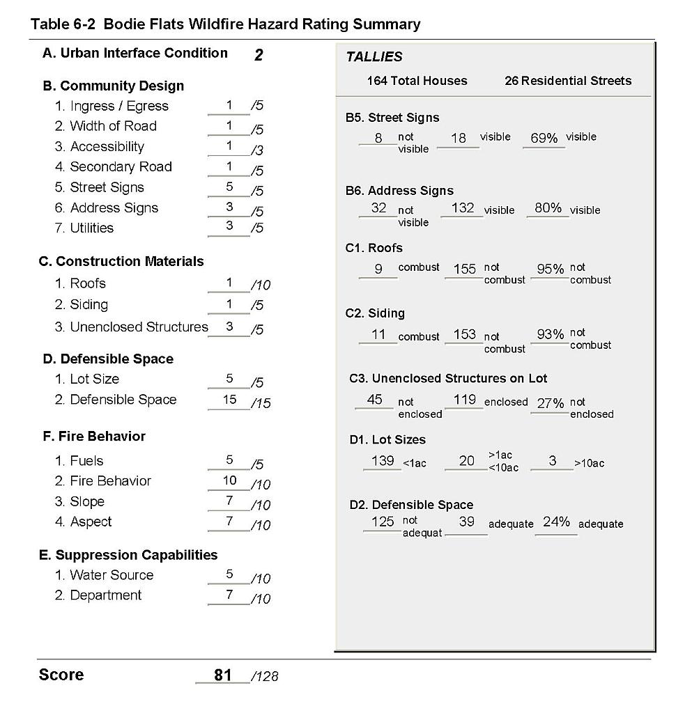 |
Figure 6-1Bodie Flats Fire History and Proposed Mitigation Projects |
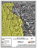 |
Figure 6-2Bodie Flats Fuel Hazard Classification |
 |
Figure 6-3. Bodie Flats Fuel Hazard Photo Points
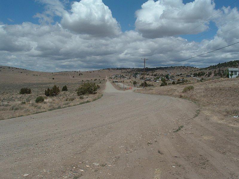
Photo Point 1. Bodie Flats Fuel Hazard Photo Point. 4303787N, 0269268E, 0°N. Three main fuel types were identified in the Bodie Flats community. Areas within previous burns are dominated by sagebrush and rabbitbrush. Fuel loads were estimated at one ton per acre and were classified as a low fuel hazard.
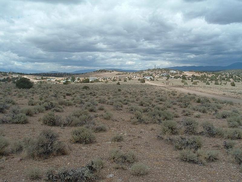
Photo Point 2. Bodie Flats Fuel Hazard Photo Point. 4304184N, 0269913E, 5°N. In unburned areas with low tree density, the dominant shrub species include big sagebrush, rabbitbrush, and Mormon tea. Bottlebrush squirreltail, Sandberg bluegrass, and cheatgrass are the primary grass species. Fuel loads were estimated at two tons per acre and the fuel hazard classified as moderate.
Photo Point 3. Bodie Flats Fuel Hazard Photo Point. 4303786N, 0269883E, 140°SE. Pinyon and juniper trees form a closed tree canopy in some of the unburned areas around the community. Where the tree canopy exists, dominant shrub species such as big sagebrush and rabbitbrush are present at lower densities. Fuel loads in this fuel type were estimated at four to seven tons per acre and were classified as an extreme fuel hazard as shown in the background of this photograph.