![]()
![]()
6.0 Carson Indian Colony
6.1 Risk and Hazard Assessment
The Carson Indian Colony, part of the Washoe Tribe of Nevada and California, is located along the western edge of Carson City just west of Curry Street. The Colony is situated at the base of the east slope of the Carson Range between C-Hill and Voltaire Canyon. The Colony is situated on both the valley floor and the piedmont slope. Approximately fifty residences were evaluated within the Carson Indian Colony that resulted in classifying the Tribal community in the Moderate Hazard category (46 points). A summary of the values that affect the hazard rating is included in Table 6-2. The primary wildfire hazard conditions in the Carson Indian Colony were limited signage on residences and vegetation or debris around some of the structures in the interface area.
6.1.1 Community Design
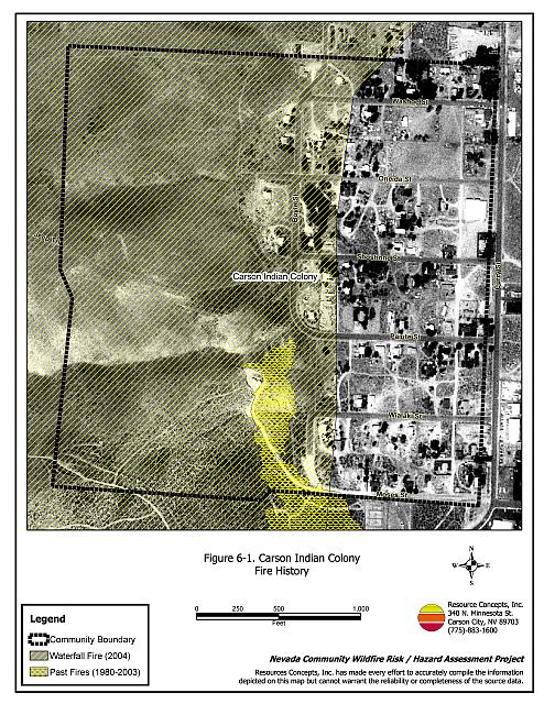
The Carson Indian Colony is characterized by a classic interface condition with some characteristics of an occluded interface condition. Throughout most of the Carson Indian Colony, there is a clear line of demarcation between structures and wildland fuels. However undeveloped vacant lots are also interspersed throughout the community with natural vegetative fuels. All of the lots assessed were on parcels of one acre or less and typically had more than three structures per acre. As such, most structures are spaced close together (see Figure 6-1).
- Access: Curry Street is the major transportation route to and from the Colony, though Boyle Street can be used to exit the community to the north. Curry Street is paved and is at least 24 feet in width. Only one dead-end road in the community limits the ability for fire suppression equipment to maneuver or turn around. All secondary roads in the community have road grades less than five percent.
- Signage: Street signs were present and visible along all streets. Residential addresses were visible on a little more than half of the homes surveyed. Clear and visible residential addresses are important to aid firefighting personnel in locating homes during low visibility conditions that may occur during a wildland fire.
- Utilities: All utilities were noted to be above ground, and power lines were properly maintained to minimize the potential for sparking power lines that could start fires in nearby vegetation during windstorms. Some propane tanks were in need of vegetation clearance.
6.1.2 Construction Materials
A great majority of the homes in the interface were built with fire-resistant siding and fire resistant composite roofing materials. Less than ten percent of homes had an unenclosed features such as a porch, balcony, or deck that create drafty places where firebrands and embers can be trapped, smolder, and ignite, readily spreading fire to the home.
6.1.3 Defensible Space
Only 38 percent of the homes assessed had landscaping that would meet the minimum defensible space requirement to help protect the home and minimize the potential for damage or loss during a wildfire. However, the majority of residences had excess vegetation and debris in close proximity to structures. There were also several abandoned structures and mobile homes identified, which can create a fire hazard for adjacent residences in the community.
6.1.4 Suppression Capabilities
Wildfire Protection Resources
The Carson City Fire Department provides wildfire and structure protection for homes in the Carson Indian Colony, however no formal agreement exists between the Washoe Tribe and the Carson City Fire Department. The Bureau of Land Management has a formal agreement with the Bureau of Indian Affairs to provide wildfire suppression resources to the 480 acres of BIA land in the municipality. The US Forest Service and the Nevada Division of Forestry also provide fire protection to the Carson City Municipality for wildland-urban interface fires. See Tables 4-2 and 4-3 for more information on fire suppression capabilities for initial attack of wildland fires.
Water Sources and Infrastructure
Water availability for fire suppression in the Carson Indian Colony includes 500 gpm hydrants within 500 feet of structures. The water system operates on gravity and electrical pumps. There is an emergency backup generator to run the pumps in the case of a power failure. The existing infrastructure for the water delivery system meets the 1997 Uniform Fire Code standards.
Community Preparedness
The Carson Indian Colony is included in the Carson City emergency plan and disaster plan. Development plans in the Colony are not reviewed by the Carson City Fire Department for fire safe design and construction.
6.1.5 Factors Affecting Fire Behavior
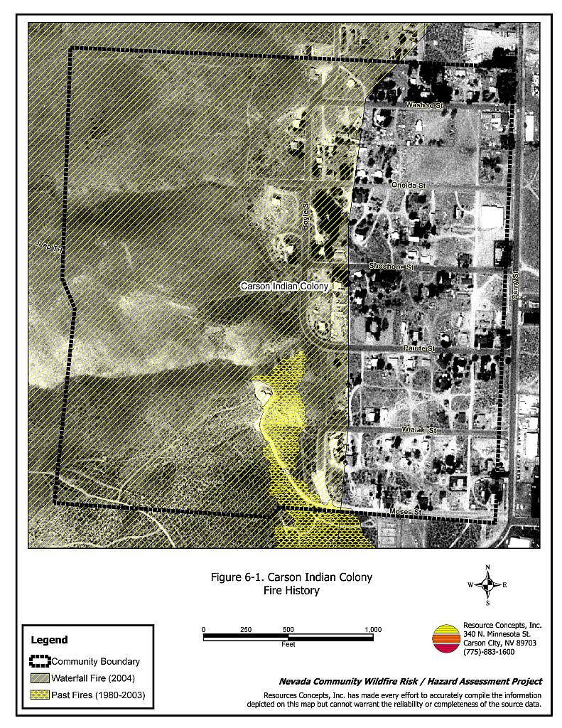
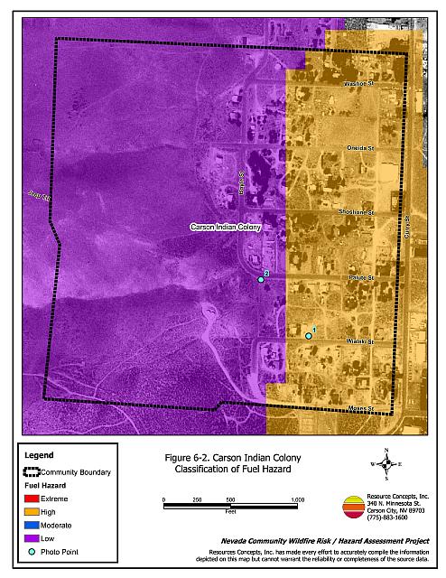
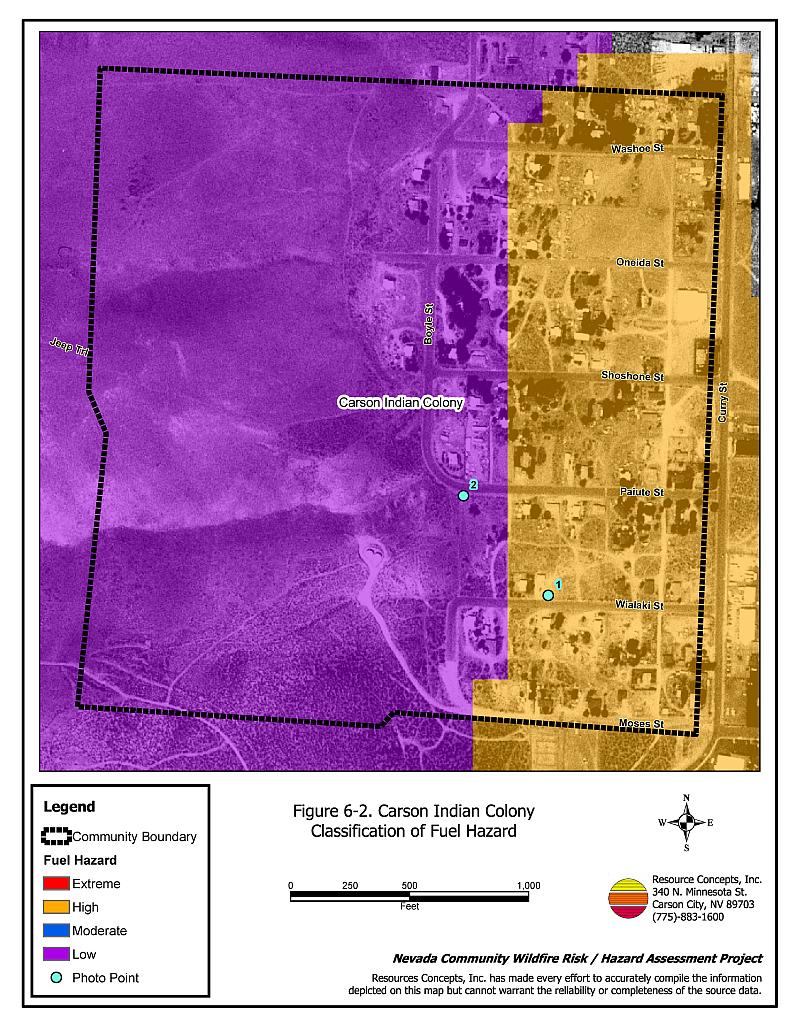
Vegetation, down fuels, and topography contribute to the potential fire hazard around wildland-urban interface communities. The fuel hazards were mapped for the Carson Indian Colony as shown in Figure 6-2. Photo points were established to document the current condition of the vegetative fuel hazard as shown in Figure 6-3. The fuel hazards mapped for the Carson Indian Colony were revised following the Waterfall Fire and reflect the most recent fuel hazard conditions.
The vegetative fuel density in and around the Carson Indian Colony interface area was generally classified as moderate. Both the Voltaire 2 Fire in 2003 and the Waterfall Fire in 2004 burned the area just west of Cason Colony residences. Vegetation density was greatly reduced in the burned areas and currently provides an effective fuelbreak from west or southwest fires. Rehabilitation and revegetation treatments have been proposed or implemented for the burned areas. If successful, the rehabilitated areas will result in maintaining low to moderate vegetative fuel density over the next ten to twenty years. Cheatgrass has a high potential of dominating the burned areas if the seeding efforts fail. The cheatgrass fuel hazard is predicted to range from low to high depending upon the amount and timing of annual precipitation.
Unburned fuels within the community are moderately dense, consisting primarily of big sagebrush, rabbitbrush, and bitterbrush ranging from three to four feet tall. Cheatgrass ground fuels provide horizontal and vertical continuity between the shrubs. The fuel loading within the Colony was estimated at two tons per acre and was considered a high fuel hazard.
The terrain around the residences is gently sloping with slopes less than 20 percent. Slopes increase from 20 to 35 percent or more just west of the residences. The predominant winds are from the south-southwest in the late afternoon. Strong downslope winds can occur during summer afternoons and evenings.
6.1.6 Previous Fire Hazard Reduction Projects
The Washoe Tribe Environmental Protection Department has completed some brush thinning within the Carson Indian Colony including chipping and removal of a portion of the large pile of brush biomass located in the center of the colony. The Environmental Protection Department is currently working with homeowners to enforce yard and community removal of flammable debris and it is planning additional brush thinning projects throughout the Colony.
6.1.7 Fire Behavior and Worst-Case Scenario
The worst-case wildfire scenario for the Carson Indian Colony would occur as a dry lightning ignition or a human caused fire started within the community. A fire started in the unburned fuels within the community could immediately threaten nearby homes.
6.1.8 Ignition Risk Assessment
The Carson Indian Colony has a high ignition risk rating. Many wildfires and ignitions have been recorded in the area adjacent to the Carson Indian Colony. There is a history of lightning strikes in the area. Ignitions are likely due to the moderate fuel load in the community, the tendency for lightning storms during the summer, and the number of wildland recreational users within the Carson City Municipality and near the Carson Indian Colony.
6.2 Risk and Hazard Reduction Recommendations, Roles, and Responsibilities
The Carson Indian Colony risk and hazard reduction recommendations focus on improving defensible space and promoting homeowner responsibilities. Other recommendations pertain to community coordination efforts that would enhance the fire safe nature of the Carson Indian Colony. Recommendations are detailed below.
6.2.1 Defensible Space Treatments
Defensible space is an essential first line of defense for residential structures. Significantly reducing or removing vegetation within a prescribed distance from structures (a minimum of 30 feet to 200 feet depending upon slope and vegetative fuel type) reduces fire intensity and improves firefighter and homeowner chances for successfully defending a structure against oncoming wildfire. Improving address identification improves firefighters’ ability to locate structures during smoky conditions.
Property Owner Responsibilities
- Remove, reduce, and replace vegetation to create defensible space around homes according to the guidelines in Appendix F. This area should be kept:
- Lean: There are only small amounts of flammable vegetation,
- Clean: There is no accumulation of dead vegetation or other flammable debris, and
- Green: Existing plants are healthy and green during the fire season.
- Remove debris and flammable materials from within the defensible space area.
- Store firewood a minimum distance of thirty feet from structures.
- Mow or remove brush growing against wood fences in the community.
- Maintain areas under wood decks and porches free of weeds and other flammable debris.
- Clear all vegetation and combustible materials around propane tanks for a minimum of ten feet.
- Spark arrestors should be installed on chimneys.
- Immediately dispose of cleared vegetation when implementing defensible space treatments. This material dries quickly and poses a fire hazard if left on site.
- Maintain this defensible space as needed to keep the space lean, clean, and green.
- Windows and doors in abandoned buildings should be boarded up. Abandoned trailers should be removed, or the windows and doors boarded up and the underneath skirted to reduce the potential for ignition from sparks or firebrands.
6.2.2 Fuel Reduction
Washoe Utilities Management Authority Responsibilities
- Continue to remove or mow vegetation within three feet of all fire hydrants to improve visibility and access to fire personnel.
Washoe Tribe Responsibilities
- Continue to promote the program for clearing weeds and debris from around structures and fences.
- Require fuel reduction on vacant lots.
6.2.3 Community Coordination
Many of the most effective activities aimed at reducing the threat of wildfire for the Carson Indian Colony require that individual homeowners coordinate with each other, the Washoe Tribe, and with local fire authorities. Defensible space, for example, is more effective in small communities when applied uniformly throughout entire neighborhoods. Public education and awareness, neighbors helping neighbors, and proactive individuals setting examples for others to follow are just a few of the approaches that will be necessary to meet the fire safe goals in the community. Disposal of biomass generated from defensible space and fuel reduction treatments can sometimes be most efficiently handled through community programs.
Property Owner Responsibilities
- Form a local chapter of the Nevada Fire Safe Council in conjunction with the Washoe Tribe of Nevada and California. The Nevada Fire Safe Council proposes to work on solutions that reduce the risk of loss of lives and property from wildfires in Nevada’s communities. Through establishment of a local Chapter, communities become part of a large information-sharing network that receives notifications of programs and funding opportunities for fire mitigation projects such as those listed in this report. The Nevada Fire Safe Council will accept and manage grants and contracts on the Chapter’s behalf through its non-profit status. The Nevada Fire Safe Council provides assistance and support to communities to complete fire safe plans, set priorities, educate and train community members, and promote success stories of its members. For more information on forming a chapter, contact:
Nevada Fire Safe Council
1187 Charles Drive
Reno, Nevada 89509
www.nvfsc.org - Assure that residential addresses are visible from the road. Address characters should be at least four inches high, reflective, and composed of non-flammable material. Improving visibility of addresses will make it easier for those unfamiliar with the area to navigate under smoky conditions caused by of a wildland fire.
6.3 Summary of Recommendations
| Involved Party | Recommended Treatment | Recommendation Description |
|---|---|---|
| Property Owners | Defensible Space Treatments | Remove, reduce, and replace vegetation around homes according to the guidelines in Appendix F. Maintain defensible space as needed to keep the space lean, clean, and green. Remove abandoned trailers. Board up windows and doors of abandoned structures. |
| Fuel Reduction Treatments | Reduce fuels at least ten feet along both sides of private driveways that are longer than 200 feet. | |
| Community Coordination | Form a local chapter of the Nevada Fire Safe Council. Improve address visibility. | |
| Washoe Utilities Management Authority | Fuels Reduction | Remove or mow vegetation within three feet of all fire hydrants to improve visibility and access to fire personnel. |
| Washoe Tribe | Fuel Reduction Treatments | Continue program to promote and facilitate cleaning weeds and debris from around structures and fences. Require property owners to reduce fuels on vacant lots in the Carson Indian Colony. |
Table 6-2Carson Indian Colony Wildfire Hazard Rating Summary |
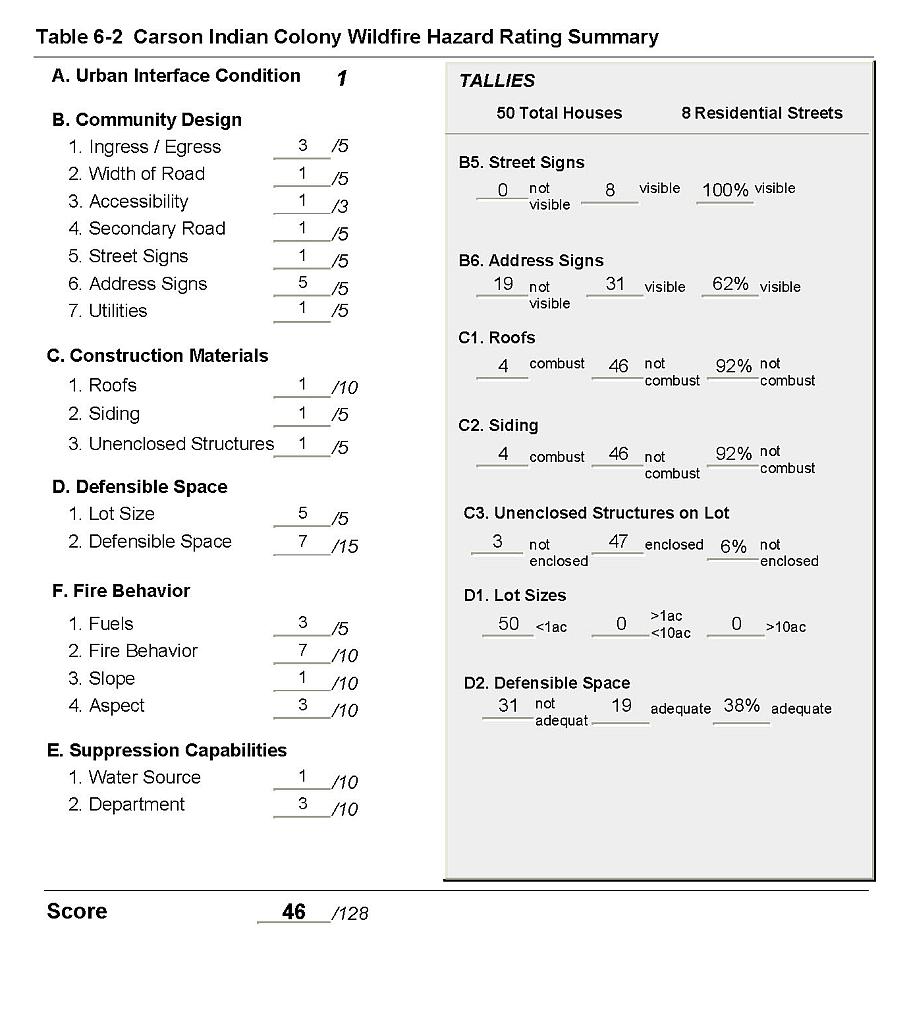 |
Figure 6-1Carson Indian Colony Fire History |
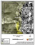 |
Figure 6-2Carson Indian Colony Classification of Fuel Hazard |
 |
Carson Indian Colony Fuel Hazard Photo Points
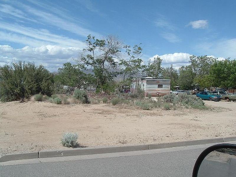
Photo Point 1. Carson Indian Colony Fuel Hazard Photo Point. 260333E, 4335652N, 352°NW. Within the Carson Indian Colony sagebrush and bitterbrush were interspersed between structures throughout the community. Fuel loads were estimated at two tons/acre and considered a high fuel hazard.
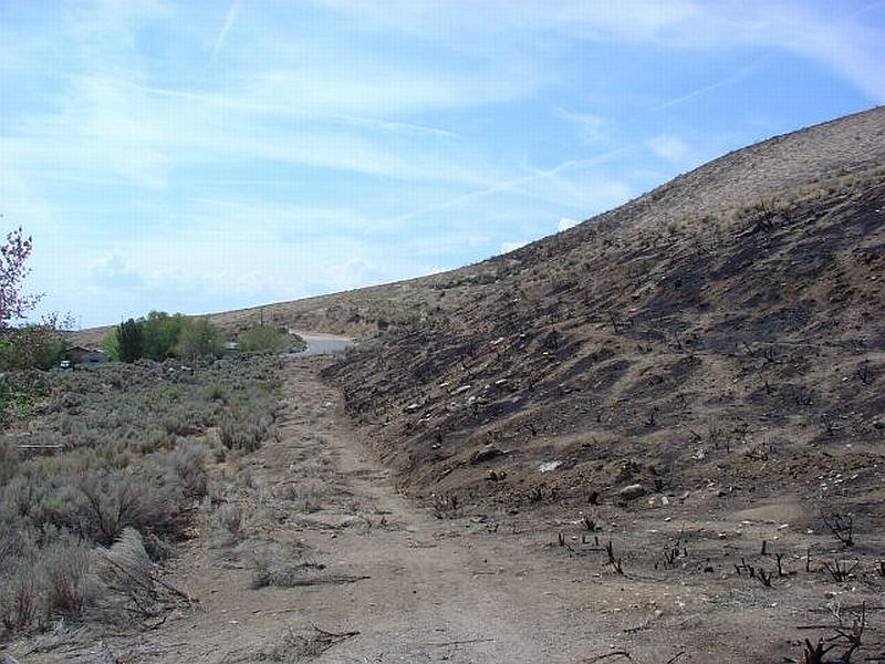
Photo Point 2. Carson Indian Colony Fuel Hazard Photo Point. 4335780N, 260224E,183°S. The Waterfall and Voltaire two fires in 2004 and 2003 have reduced the fuel hazard to low west of the Carson Indian Colony.