![]()
![]()
7.0 Six Mile
7.1 Risk and Hazard Assessment
Six Mile is a community located at an elevation of 4,500 feet at the base of south facing slopes near the south end of the Virginia Range. The community is located just north of the Lyon-Storey County line adjoining the community of Mark Twain to the south in Lyon County (see the Lyon County Risk/Hazard Assessment report in this series for a discussion of Mark Twain). The risk assessment resulted in classifying Six Mile in the Moderate Hazard category (58 points). A low fire behavior potential, as well as and moderate levels of combustible building materials, architectural features, community accessibility, visibility of residential addresses, fire suppression infrastructure and resources, and structure density are some of the features that contributed to the moderate hazard score. A summary of the factors is included in Table 7-2.
7.1.1 Community Design
The wildland-urban interface condition surrounding Six Mile is intermixed. Structures are scattered throughout the wildland area with no clear line of demarcation between wildland fuels, buildings, and undeveloped open space throughout the community. Of the 260 residences evaluated in the community, 256 are on parcels ranging between one and ten acres and the remaining four residences are on parcels of greater than ten acres.
- Roads: State Route 79, one of the primary access roads for the community, is moderately narrow (between 20 and 24 feet wide), paved, and has adequate turnaround space for fire suppression equipment. One percent of the secondary roads have grades steeper than five percent.
- Signage: Street signs were present along all but one of the streets. Residential addresses were visible on about 75 percent of the houses.
- Utilities: All of the utilities are above ground and well maintained.
7.1.2 Construction Materials
Of the 260 homes assessed, 83 percent had been built with fire resistant siding materials and nearly all of them have fire resistant roofing materials (composition, metal, or tile). Approximately half of the homes observed had unenclosed balconies, porches, decks, or other architectural features that can create drafts and provide areas where sparks and embers can accumulate, smolder, ignite, and rapidly spreading fire to the home.
7.1.3 Defensible Space
Approximately one quarter of the homes have landscaping that meets the defensible space requirement to protect the home from damage or to minimize loss during a wildfire. The defensible space requirement is based on vegetation and slope as illustrated in Appendix E of this report.
7.1.4 Suppression Capabilities
Wildfire Protection Resources
The Six Mile Volunteer Fire Department is based out of Storey County Fire Station #3 in Six Mile. At the time of inquiry, the Six Mile Volunteer Fire Department reported seventeen volunteers on call (G. Hames, pers. comm.). Resource availability and mutual aid agreements with Storey County Fire Protection District are described in Section 4.1.1.
Water sources and Infrastructure
There are no fire hydrants or community water systems in Six Mile. Supplemental water for fire suppression is in Lyon County with a twenty-minute turnaround time.
Community Preparedness
The Storey County Fire Department has an informational web page in development (www.storeyfire.com) and offers periodic programs for the public to increase community fire awareness and fire safety. The fire department also carries out building safety inspections on a regular basis.
7.1.5 Factors Affecting Fire Behavior
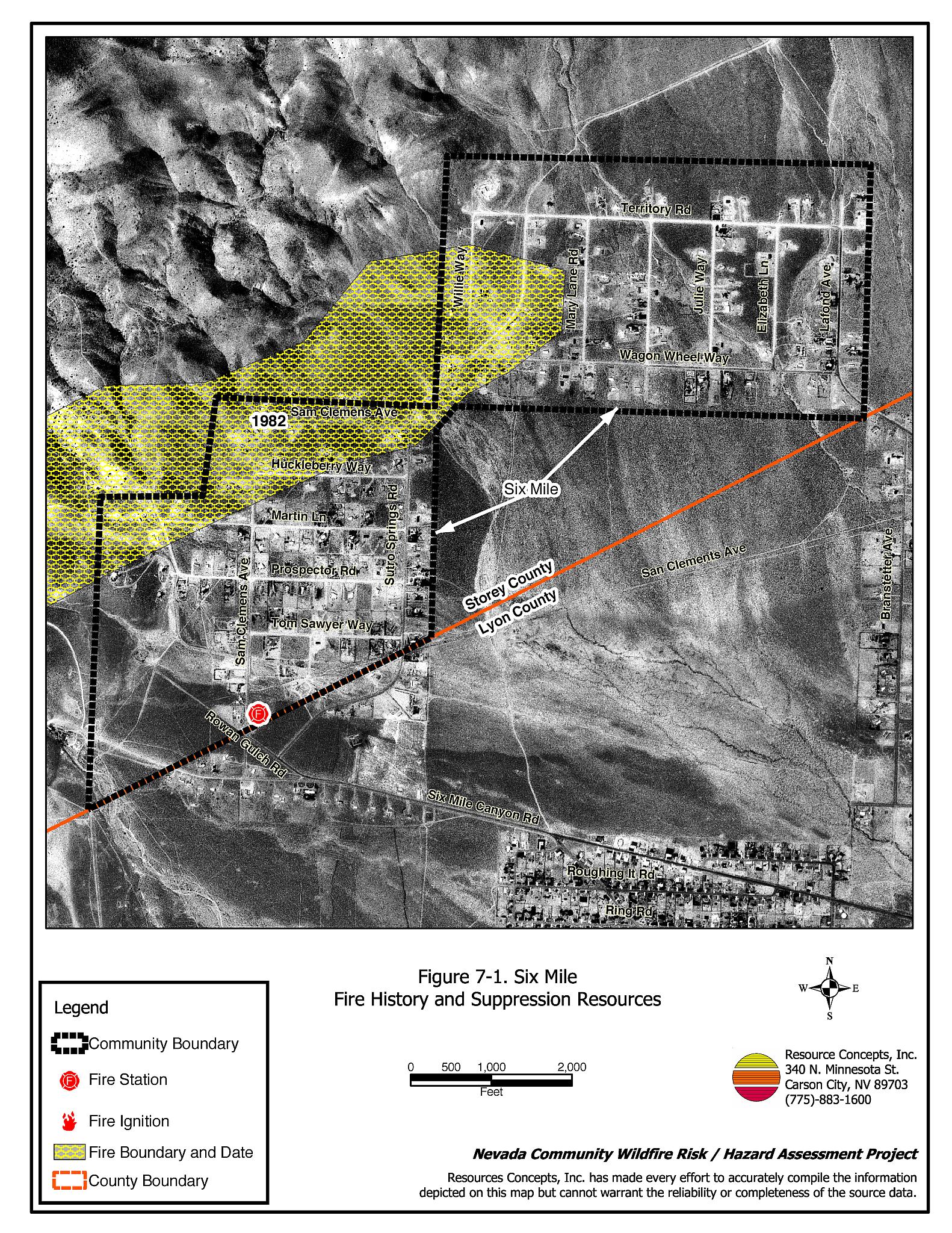
Slopes in the area are mild, between zero and ten percent. The interface slopes with south or southeast aspects contribute to more rapid drying and increased flammability of fuels. Reported wildland fire history shows a 1982 burn that extended in an east- west band across the foothills west of the community including what is now Huckleberry Way, the north extension of Sam Clemens Avenue, and part of Willie Way. The predominant wind directions in the area are south or southwest, although winds could come from any direction given the open terrain. Light to medium density fuels in the interface area are mostly sagebrush with some rabbitbrush, two to three feet in height. Fuel loading was estimated to be less than one ton per acre and was considered a low fuel hazard.
7.1.6 Fire Behavior Worst-case Scenario
The worst-case wildfire scenario would be a fire that starts mid-afternoon during the summer months when winds from any direction could drive the fire into the community. Winds 25-35 mph could drive flame lengths of eight to ten feet into residences and other structures of the community. Heavy tourist traffic en route to and from Virginia City would exacerbate the worst-case wildfire scenario.
7.1.7 Ignition Risk Assessment
Reported ignitions in the Six Mile area are scarce, as shown in Figure 7-1, resulting in a low ignition risk rating for the community.
7.2 Risk and Hazard Reduction Recommendations and Responsibilities
The risk and hazard reduction recommendations for Six Mile prioritize defensible space treatments within the community. Community coordination and public education are important recommendations that work in conjunction with each other to facilitate implementation and long-term maintenance of defensible space and fire safety awareness. Roles and responsibilities are summarized in Table 7-1.
7.2.1 Defensible Space
Vegetation density, type of fuel, and slope gradient around a home affect the potential fire exposure levels to the home. The goals of defensible space are to reduce the risk of property loss from wildfire by eliminating flammable vegetation near the home, thereby lowering the potential to burn, and to provide firefighters a safer working area from which to defend the home or outbuilding during a wildland fire. Guidelines for improving defensible space around residences and structures in the community are given below and are described in detail in Appendix E.
Property Owner Responsibilities
- Remove, reduce, and replace vegetation to create defensible space around homes according to the guidelines in Appendix E. This area should be kept:
- Lean: There are only small amounts of flammable vegetation,
- Clean: There is no accumulation of dead vegetation or other flammable debris, and
- Green: Existing plants are healthy and green during the fire season.
- Shrubs should be thinned to a spacing equal to twice their height.
- Prune any remaining trees so that branches are at least fifteen feet away from buildings and chimneys. Prune and remove all dead and diseased branches from trees.
- Maintain a minimum clearance of thirty feet from the crown of trees to structures and other tree crowns that remain within the defensible space zone. Keep this area free of smaller trees, shrubs, and other ladder fuels.
- Clear weeds and brush at a width of ten feet along both sides of driveways.
- Mow, prune, or remove brush growing within ten feet of fences in the community.
- Clear all vegetation and combustible materials around propane tanks for a minimum distance of ten feet.
- Store firewood a minimum distance of thirty feet from structures.
- Maintain areasunder wood decks and porches free of weeds and other flammable debris. Install screens around unenclosed overhangs where possible.
- Immediatelydispose of cleared vegetation when implementing defensible space treatments. This material dries quickly and poses a fire hazard if left on site.
- If possible, irrigate all remaining trees and large shrubs in close proximity to structures to increase their fire resiliency. This is especially important during drought conditions.
- Maintain defensiblespace annually.
7.2.2 Community Coordination
Many of the most effective activities aimed at reducing the threat of wildfire for the Six Mile Community require that individual property owners coordinate with each other and with local fire authorities. Defensible space, for example, is more effective in small communities when applied uniformly throughout entire neighborhoods. Public education and awareness, neighbors helping neighbors, and proactive individuals setting examples for others to follow are just some of the approaches that will be necessary to meet the fire safe goals in the community.
Disposal of biomass generated from defensible space treatments can often be most efficiently handled through community programs.
Property Owner Responsibility
- Cooperate with the neighboring community of Mark Twain (Lyon County) to form a local chapter of the Nevada Fire Safe Council. The Nevada Fire Safe Council facilitates solutions to reduce the loss of lives and property from wildfire in Nevada’s communities. Through the establishment of a local Chapter, local communities will become part of a large network for sharing information, including notification of programs and funding opportunities for fire mitigation projects such as those listed in this report. The Nevada Fire Safe Council will accept and manage grants and contracts on the Chapter’s behalf through its non-profit status. The Nevada Fire Safe Council will provide assistance and support to communities to complete fire safe plans, set priorities, educate and train community members, and promote success stories of its members. To form a local Chapter or for more information contact the:
Nevada Fire Safe Council
1187 Charles Drive
Reno, Nevada 89509
(775) 322-2413
www.nvfsc.org
- Assure that address signs are visible from the road. Address characters should be at least four inches high, reflective, and composed of non-flammable material. Improving visibility of addresses will make it easier for those unfamiliar with the area to navigate under smoky conditions during a wildland fire.
Storey County Commissioner Responsibilities
- Require all future development in the County meet the national fire codes with regard to community design aspects; building construction and spacing; road construction and design; water supply; and emergency access. Refer to Appendix F for an example of fire safe recommendations for planning new developments.
7.2.3 Public Education
Public education about fire safety is critical. A program that explains fire safe measures in clear and emphatic terms will have an impact on residents of the wildland-urban interface. Informed community members will be more inclined to make efforts in effectively reducing the wildfire hazards to their homes and neighborhoods.
Storey County Fire Department Responsibilities
- Distribute copies of the publication “Living with Fire” to all property owners. This publication is free of charge. Copies can be requested from the University of Nevada Cooperative Extension.
- Enforce or develop county laws, regulations, and ordinances that support implementation and maintenance of defensible space, and address fuel reduction responsibilities for absentee homeowners and vacant lots.
- Contact the University of Nevada Cooperative Extension and the BLM Carson City Field Office for assistance with public education.
7.3 Summary of Recommendations
| Responsible Party |
Recommended Treatment |
Recommendation Description |
|---|---|---|
| Property Owners | Defensible Space | Remove, reduce, and replace vegetation around structures according to the defensible space guidelines in Appendix E. Improve address visibility from roads. |
| Community Coordination | Coordinate with the community of Mark Twain to form a joint local chapter of the Nevada Fire Safe Council. Participate in public education opportunities and become knowledgeable of emergency evacuation procedures. Organize community clean-up events to remove weeds and debris in town and facilitate timely disposal of cleared vegetative fuels. Expand the use of address and street signage where needed. |
|
| Storey County Fire Department | Public Education | Allow burning only under a permit process or on designated community burning days. Enforce or develop county laws, regulations, and ordinances for defensible space and fuel reduction that include responsibilities for absentee homeowners, vacant lots, and new subdivisions. Distribute copies of the publication “Living with Fire” to all property owners. Contact the Nevada Cooperative Extension and BLM for assistance with public education. |
| Storey County Commissioners | Community Coordination | Require all future development in the County meet the national fire codes with regard to community design aspects, building construction and spacing, road construction and design, water supply, and emergency access. |
Figure 7-1Six Mile Fire History and Suppression Resources |
 |
Table 7-2Six Mile Wildfire Hazard Rating Summary |
 |