![]()
![]()
5.0 Gold Hill
5.1 Risk and Hazard Assessment
Gold Hill is located at 6,000 feet in the Virginia Range in the heart of a very large historic mining district and is adjoined to the north by Virginia City. The town does not have its own fire department and is served by the Storey County Fire Station #1 in Virginia City. The town is situated two-thirds of the way up Gold Canyon at the base of steep, west-facing slopes, which contribute to a high fire behavior potential. Gold Hill was classified in the High Hazard category (72 points). Elements affecting the hazard rating were steep secondary roads, poor defensible space, and the potential hazard presented by some overhead utilities. Scores for Gold Hill are included at the end of this chapter in Table 5-2.
5.1.1 Community Design
The area surrounding Gold Hill is classified as an intermix wildland-urban interface condition. The RCI Project Team observed a total of 25 structures scattered throughout the wildland area with no clear line of demarcation between wildland fuels and the buildings. There is undeveloped open space throughout the community. Approximately two-thirds of the lots assessed were less than one acre. The remaining parcels were between one and ten acres in size. As such, most structures are spaced closely together, though a few structures are surrounded by sizeable expanses of vacant land.
- Roads: State Route 342 is the primary access road for the community. This road is paved at least 24 feet wide and provides adequate turnaround space for fire suppression equipment. Approximately twenty percent of the secondary roads have grades steeper than five percent.
- Signage: Street signs were present along all but one street. Residential addresses were clearly visible on approximately half of the houses.
- Utilities: All of the utilities are above ground. Many areas within power line corridors are in need of vegetation clearing and thinning.
5.1.2 Construction Materials
The majority of the homes observed in the interface were not built with fire resistant siding materials. All homes had fire resistant roofing materials such as composition roofing, metal, or tile. Approximately one half of the homes observed had unenclosed balconies, porches, decks, or other architectural features that create drafts and provide areas where sparks and embers can accumulate, smolder, ignite, and rapidly spread fire to the home.
5.1.3 Defensible Space
Approximately 36 percent of the residences assessed have landscaping that meets the minimum defensible space requirement to help protect a home from damage and minimize loss during a wildfire. The nature of the fuels surrounding a home and the slope of the home site will determine the specifications for defensible space. Fuels in the area are generally moderate and discontinuous in and around town. Some slopes in the canyon reach seventy to eighty percent. See the Defensible Space Guidelines and the Homeowner’s Annual Checklist in Appendix E for specific information on defensible space.
5.1.4 Suppression Capabilities
The first alarm response to a fire in Gold Hill comes from Fire Station #1 in Virginia City, which is staffed by a combination of paid and volunteer firefighters with a payroll of six fire professionals and seventeen volunteers at the time of inquiry (G. Hames, pers. comm.).
Central Lyon County Fire Protection District-Silver City Station #34 automatically aids the Storey County Fire Station #1 in all fire events. Resource availability and mutual aid agreements with Storey County Fire Protection District are described in Section 4.1.1.
Water Sources and Infrastructure
- Gold Hill has 500 gpm water hydrants within 500 feet of the structures.
- There are several water tanks totaling 3-million gallons. A new 2-million gallon tank will be installed in 2005 in Virginia City.
All water originates from Marlette Lake and is transported to the municipal system via pipeline. The water system is run by both gravity and electric pumps with an emergency back-up generator. The water systems meet or exceed the current codes.
5.1.5 Factors Affecting Fire Behavior
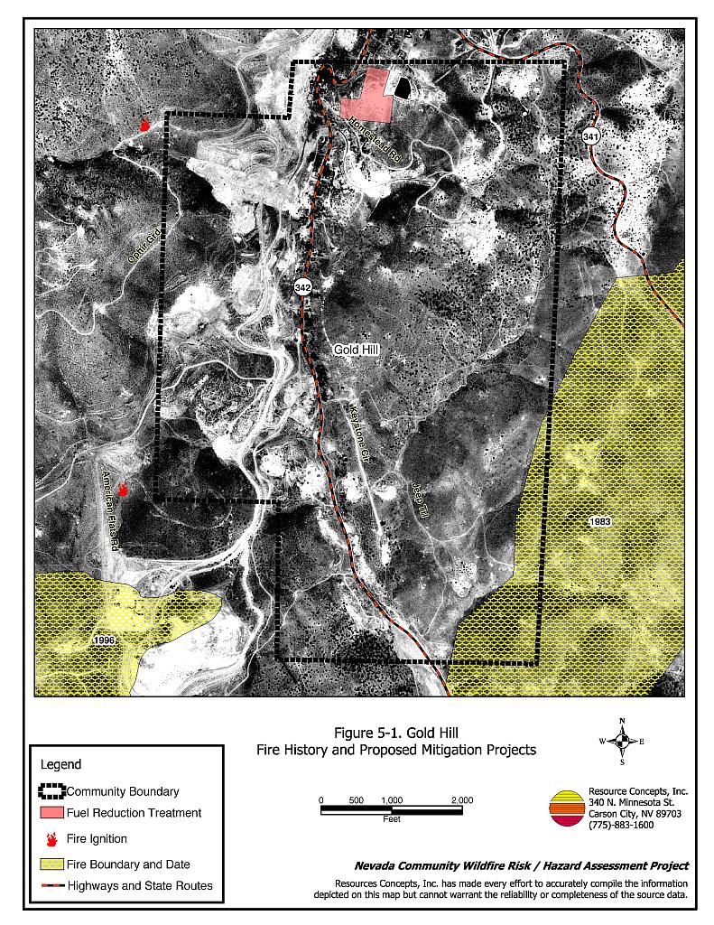
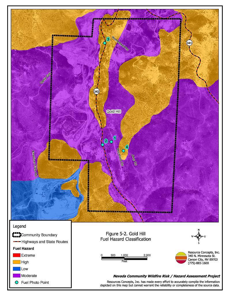
The vegetation fuel hazard in the Gold Hill interface area is predominantly moderate to high as shown in Figure 5-2. Pinyon and juniper occur on the steep slopes east, southwest, and northwest of Highway 342 where the fuel hazard is high. Areas considered a moderate fuel hazard consist mostly of shrubs two to three feet tall including big sagebrush, bitterbrush, rabbitbrush, and desert peach. Cheatgrass is intermixed with native bunchgrass species throughout most of the interface, which presents a readily ignitable fuel bed and can elevate shrublands to a high fuel hazard in wet years. The fuel condition of greatest concern is located within the most densely occupied residential area along Highway 342 where dense fuels and steep slopes coincide with structures built of highly combustible materials. Fuel hazard photographs are included in Figure 5-3.
Slopes in the area reach seventy to eighty percent. Steep conditions are conducive to the uphill spread of fire. West and south-facing aspect slopes tend to be drier and are therefore more receptive to ignition. There is a moderate fire history in the vicinity of Gold Hill: one fire burned within less than a mile of town to the south and to the east in 1983 and a subsequent fire consumed an area to the south west of town in 1996. The prevailing winds in the area are from the south, a condition that would be a major factor in the worst-case wildfire scenario.
5.1.6 Fire Behavior Worst-case Scenario
The worst-case wildfire scenario would be a fire that starts south of town on a windy summer afternoon with heavy tourist traffic in the area. Gold Hill is positioned about two-thirds of the way up Gold Canyon, which is a topographic feature that could create a chimney effect concentrating upslope winds from the south. An ignition point south of town caused by one of many sources (e.g. lightning, auto fire, power line) would be rapidly pushed upslope into the community and into structures before fire suppression resources could take an effective defensive position. A fire in the canyon would also block the downhill escape route along Highway 342 and potentially threaten Virginia City to the north. An accelerated wind-driven fire along the drier east side (west aspect) of Gold Canyon would tend to put more property at risk, as the majority of homes and buildings are concentrated there.
5.1.7 Ignition Risk Assessment
Gold Hill was determined to have a high ignition risk rating due in part to heavy traffic in the narrow canyon during tourist season and due to the popular and easily accessible four-wheel drive trails in the area.
5.2 Risk and Hazard Reduction Recommendations and Responsibilities
The responsibility to keep a community fire safe falls not only on the local fire protection district but also on the residents of the community, businesses, and local governments. The recommendations for Gold Hill focus primarily on efforts that property owners and community members can undertake to increase wildfire safety through reduction of hazardous fuels in town. The recommendations are detailed below and summarized in Table 5-1.
5.2.1 Defensible Space Treatments
Vegetation density, type of fuel, and slope gradient around a home affect the potential fire exposure levels to the home. The goals of defensible space are to reduce the risk of property loss from wildfire by eliminating flammable vegetation near the home, thereby lowering the potential to burn and to provide firefighters a safer working area to defend the home or outbuilding during a wildland fire. Guidelines for improving defensible space around residences and structures in the community are given below and are described in detail in Appendix E.
Property Owner Responsibilities
- Remove, reduce, and replace vegetation to create defensible space around homes according to the guidelines in Appendix E. This area should be kept:
- Lean: There are only small amounts of flammable vegetation,
- Clean: There is no accumulation of dead vegetation or other flammable debris, and
- Green: Existing plants are healthy and green during the fire season.
- Store firewood a minimum distance of thirty feet from structures.
- Mow or remove brush growing within ten feet of fences in the community.
- Maintain areas under wood decks and porches free of weeds and other flammable debris. Install screens around unenclosed overhangs where possible.
- Clear all vegetation and combustible materials around propane tanks for a minimum distance of ten feet.
- Clear weeds and brush to a width of ten feet along both sides of the driveways.
- Maintain a minimum clearance distance of thirty feet from the crown of trees to structures and other tree crowns that remain within the defensible space zone. Keep this area free of smaller trees, shrubs, and other ladder fuels.
- Trim and remove tree branches a minimum of four feet from the ground to reduce ladder fuels on all deciduous and coniferous trees within the defensible space zone. Prune and remove all dead and diseased branches.
- Prune all tree branches to a minimum distance of fifteen feet from buildings, paying special attention around chimneys.
- Thin sagebrush and other shrubs to a distance of twice their height between shrubs.
- Immediately dispose of cleared vegetation when implementing defensible space treatments. This material dries quickly and poses a fire hazard if left on site.
- Where possible, irrigate all trees and large shrubs that remain in close proximity to structures to increase their fire resiliency. This is especially important during drought conditions.
- Maintain the defensible space as needed.
5.2.2 Fuels Reduction Treatments
It is important to keep power line corridors and transformers clear of flammable vegetation, as fires have been known to start from arcing power lines during windy conditions or exploding transformers during periods of high electricity use. Damage by fire to power lines often creates power failures, which are especially dangerous to communities without a backup energy source. During a wildfire, energized power lines may fall and create additional hazards for citizens and firefighters, including blocked road access.
Utility Company Responsibilities
- Reduce and remove vegetation to maintain clearance around power lines. Clear vegetation within fifteen feet of utility poles near the community. Remove all tree limbs from power lines.
Storey County Fire Department Responsibilities
- Remove or mow vegetation within ten feet of fire hydrants to improve visibility and access by fire personnel.
- Implement a fuel reduction treatment on approximately 8.5 acres below the water treatment facility located west of Highway 342 between Gold Hill and Virginia City as shown in Figure 5-1. Break up the horizontal continuity of the fuel bed by thinning shrubs to spacing equivalent to twice their height. Revegetate interspaces with the procedures identified in Appendix E. Control cheatgrass if necessary by mowing prior to seed maturity.
Storey County and Nevada Department of Transportation Responsibilities
- Reduce and remove fuels along county roads, State Routes, and highways using brush hogs or mowers to reduce the vegetation height to four inches for a distance of 25 feet on both sides of the road or to the fenced right-of-way boundary.
5.2.3 Community Coordination
Property Owner Responsibilities
- Form a local chapter of the Nevada Fire Safe Council. The Nevada Fire Safe Council facilitates solutions to reduce the loss of lives and property from wildfire in Nevada’s communities. Through the establishment of a local Chapter, local communities will become part of a large network for sharing information including notification of programs and funding opportunities for fire mitigation projects such as those listed in this report. The Nevada Fire Safe Council will accept and manage grants and contracts on the Chapter’s behalf through its non-profit status. The Nevada Fire Safe Council will provide assistance and support to communities to complete fire safe plans, set priorities, educate and train community members, and promote success stories of its members. To form a local Chapter or for more information contact the:
Nevada Fire Safe Council
1187 Charles Drive
Reno, Nevada 89509
(775) 322-2413
www.nvfsc.org
- Assure that residential addresses are visible from the road. Address characters should be at least four inches high, reflective, and composed of non-flammable material. Improving visibility of addresses will make it easier for those unfamiliar with the area to navigate under smoky conditions in the event of a wildland fire.
- Read and become fully knowledgeable of evacuation procedures, fire safety zones, and safety procedures for sheltering in place in the event that evacuation is not possible.
Storey County Commissioner Responsibilities
- Require all future development in the County to meet the national fire codes with regard to community design aspects, building construction and spacing, road construction and design, water supply, and emergency access. Refer to Appendix F for an example of fire safe recommendations for planning new developments.
5.2.4 Public Education
Public education focused on increasing community fire safety is critical. A program that explains fire safe measures in clear and emphatic terms will have an impact on residents in the wildland-urban interface. Informed community members will be more inclined to take actions to effectively reduce fuels and other wildfire hazards around their homes and in their neighborhoods.
It is also critically important for residents to be fully knowledgeable of evacuation routes and procedures. A group of volunteers should be trained and prepared to assist in directing tourists to designated safe zones and evacuation routes in the event that emergency evacuation is necessary.
Storey County Fire Department
- Complete and distribute copies of the Gold Hill emergency evacuation plan to all residents. Conduct public workshops each year prior to the tourist and fire season to ensure that all residents are fully knowledgeable of evacuation routes, evacuation procedures, designated fire safe zones, and procedures for sheltering in place in case evacuation becomes infeasible during a fast moving fire storm.
- Distribute copies of the publication Living with Fire to all property owners. This publication is free of charge. Copies can be requested from the University of Nevada Cooperative Extension.
- Enforce or develop county laws, regulations, and ordinances that support implementation and maintenance of defensible space and establish fuel reduction responsibilities for absentee homeowners and vacant lots.
- Contact the University of Nevada Cooperative Extension and the BLM Carson City Field Office for assistance with public education.
5.3 Summary of Recommendations
| Responsible Party |
Recommended Treatment | Recommendation Description |
|---|---|---|
| Property Owners | Defensible Space | Remove, reduce, and replace vegetation around home according to the defensible space guidelines in Appendix E. |
| Community Coordination | Form a local chapter of the Nevada Fire Safe Council. Improve address visibility. Participate in public education opportunities and become knowledgeable of emergency evacuation procedures. |
|
| Utility Company | Fuels Reduction | Reduce and remove vegetation in power line corridors. Maintain fifteen feet of clearance around utility poles. |
| Storey County And NDOT |
Fuels Reduction | Reduce and remove vegetation in county road, State Route, and highway right-of ways to maintain an average four-inch vegetation height. Reseed treated areas to minimize cheatgrass and noxious weed invasion. |
| Storey County Commissioners | Community Coordination | Require all future development in the County meet the national fire codes with regard to community design aspects, building construction and spacing, road construction and design, water supply, and emergency access. |
| Storey County Fire Department | Fuels Reduction | Remove or mow vegetation within ten feet of fire hydrants to improve visibility and access by firefighters. Implement fuels reduction treatment on 8.5 acres in the vicinity of the water treatment facility west of Highway 342. |
| Public Education | Complete and distribute the Gold Hill emergency evacuation plan. Conduct annual workshops to train residents on evacuation procedures and safety procedures for sheltering in place. Enforce or develop county laws, regulations, and ordinances for defensible space and fuel reduction that include responsibilities for absentee homeowners, vacant lots, and new subdivisions. Distribute copies of the publication “Living with Fire” to all property owners. Contact the Nevada Cooperative Extension and BLM for assistance with public education. |
Figure 5-1Gold Hill Fire History and Proposed Mitigation Projects |
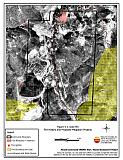 |
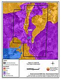
Figure 5-2Gold Hill Fuel Hazard Classification |
 |
Gold Hill Fuel Hazard Photo Points

Photo Point 1. 0271040N. 4351229E. Direction 160°SSE. Moderate fuel hazard. Typical fuels include cheatgrass and sagebrush with scattered pinyon and juniper trees. The fuel hazard can escalate in a wet year to a high or extreme hazard condition as a result of high cheatgrass production.
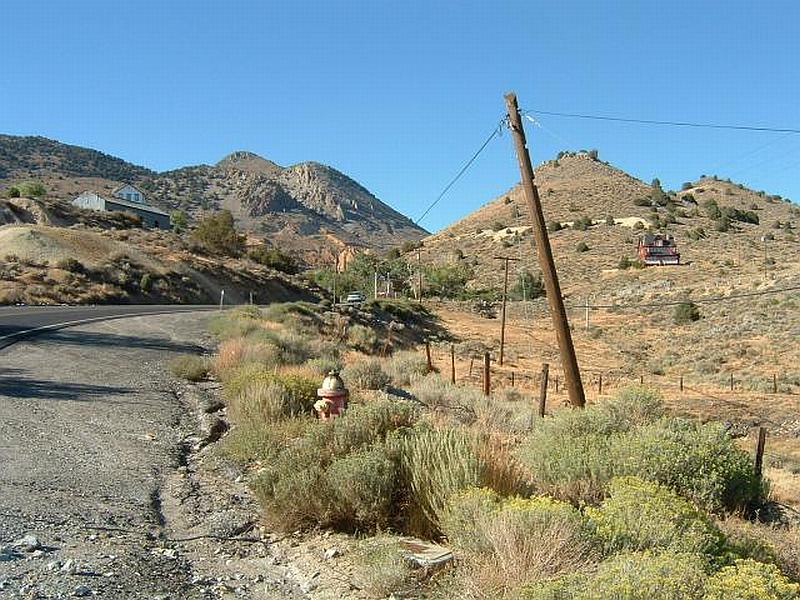
Photo Point 2. 0270922N. 4351190E. Direction 12°NNE. Moderate fuel hazard area. Recommendations for Gold Hill include reduction and removal of vegetation within ten feet of fire hydrants to improve visibility and access by fire personnel and removal of fuels along county roads using brush hogs or mowers to reduce vegetation height to four inches for a distance of 25 feet on both sides of the road or to the fenced right-of-way boundary.

Photo Point 3. 0270951N. 4352553E. Direction 171°SSE. High fuel hazard at the interface in Gold Hill. Continuous fuels of pinyon, juniper, and black locust on steep slopes extend to the edge of structures.

Photo Point 4. 0271202N. 4351109E. Direction 12°NNE. High fuel hazard consists of a pinyon and juniper woodland overstory with sagebrush and cheatgrass in the understory. Fuel reduction from a past fire in 1983 (right) still maintains a moderate fuel hazard as compared to the unburned pinyon-juniper woodland (left). If left untreated, the pinyon and juniper will continue to expand downslope and worsen the fuel hazard for Gold Hill.
Table 5-2Gold Hill Wildfire Hazard Rating Summary |
 |