![]()
![]()
3.0 Description of the County
3.1 Demographics, Location, Topography, and Climatic Data
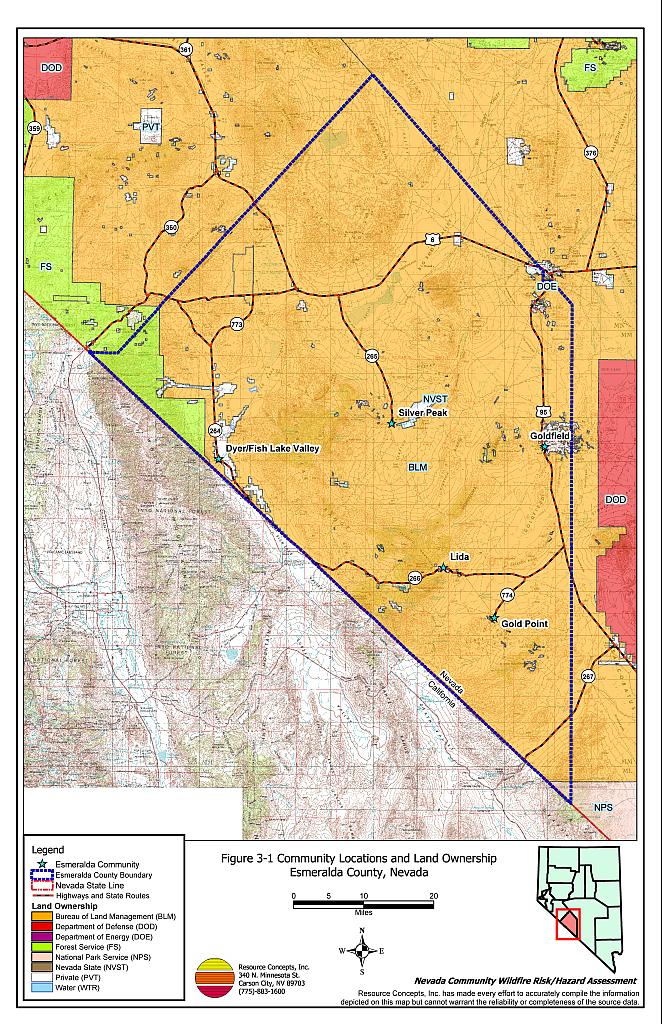
Esmeralda County is located in western Nevada, between Mineral and Nye counties and along the Nevada/California border. The County is approximately 2,294,000 acres in size. A summary of land management administration is provided in Table 3-1 and depicted in Figure 3-1.
| Land Administrator | Acres | Percent of Total |
|---|---|---|
| Bureau of Land Management | 2,170,039 | 94 |
| US Forest Service | 65,519 | 3 |
| State of Nevada | 867 | <1 |
| Private | 53,710 | 2 |
| National Park Service | 3,411 | <1 |
| Other (Water) | 452 | <1 |
| Approximate values derived from BLM land ownership GIS database. | ||
The Bureau of Land Management administers 94 percent of the lands in Esmeralda County. Approximately two percent of the county is private land with a current population estimate of 1,116 persons (Nevada State Demographer 2003). Service industries and local government are the main employers in the county.
The Silver Peak range and the Montezuma Mountains extend through the center of the county. The White Mountains border the county to the west. Gold Mountain Peak occupies the southeast corner of the county. Elevations within the county range from 3,720 feet on the border with Inyo County to 13,140 feet at Boundary Peak in the White Mountains.
Overall, Esmeralda County is one of the driest regions in Nevada. Rainfall averages about three inches annually.
3.2 Wildfire History
There has been minimal wildland fire activity in Esmeralda County over the last 22 years (Nevada BLM State Office 2002). Figure 3-2 illustrates the wildfire history in the county during that period. Table 3-2 summarizes fire history and fire ignitions by year.
| Year | Number of Fire Ignitions | Total Fire Acreage |
|---|---|---|
| 1980 | 1 | 12 |
| 1981 | 1 | 30 |
| 1982 | 0 | 0 |
| 1983 | 0 | 0 |
| 1984 | 1 | 0 |
| 1985 | 0 | 0 |
| 1986 | 1 | 1 |
| 1987 | 0 | 0 |
| 1988 | 1 | 0 |
| 1989 | 0 | 0 |
| 1990 | 1 | 0 |
| 1991 | 0 | 0 |
| 1992 | 1 | 0 |
| 1993 | 0 | 0 |
| 1994 | 0 | 0 |
| 1995 | 2 | 0 |
| 1996 | 4 | 1401 |
| 1997 | 0 | 0 |
| 1998 | 0 | 0 |
| 1999 | 4 | 773 |
| 2000 | 2 | 0 |
| 2001 | 0 | 0 |
| 2002 | 0 | 0 |
| 2003 | 1 | 0 |
| TOTAL | 20 | 2217 |
| Source: Fire ignition and base acreage data provided by the National Interagency Fire Center, Boise, Idaho. | ||
3.2.1 Ignition Risk Factors
Ignition risks for wildfires fall into two categories - lightning and human caused. Human caused ignitions can derive from a variety of sources such as fires started along highways and county roads from burning material thrown out of vehicle windows or ignited during auto accidents, off-road vehicles, railroads, arcing power lines, agricultural fires, ditch burning, debris burning in piles or burn barrels, burning matches, and fireworks. In Esmeralda County, database records indicate that of twenty wildland fire incidents recorded by ignition source between 1981 and 2003 fourteen were due to natural causes and six were human caused. The primary ignition risks in Esmeralda County, based on the professional judgment of fire suppression personnel, are dry lightning from thunderstorms and human caused ignitions such as campfires, fireworks, off-road vehicles, or highway-related ignitions.
3.2.2 Fire Ecology
The science of fire ecology is the study of how fire contributes to plant community structure and species composition. A “fire regime” is defined in terms of the average number of years between fires under natural conditions (fire frequency), and the extent to which dominant vegetation is replaced by fire (fire severity). Natural fire regimes have been affected throughout most of Nevada by twentieth century fire suppression policies. Large areas that formerly burned with high frequency but low intensity (fires more amenable to control and suppression) are now characterized by large accumulations of unburned fuels, which once ignited, will burn at higher intensities.
Big sagebrush is the most common plant community in Nevada with an altered fire regime, now characterized by infrequent, high-intensity fires. Sagebrush requires ten to twenty or more years to reestablish on burned areas. During the interim these areas can provide the conditions for establishment and spread of invasive species and in some cases inhibit sagebrush reestablishment. The most common invasive species to reoccupy burned areas in Esmeralda County are annual plants including Russian thistle, halogeton, red brome and cheatgrass.
The total height and volume of annual plant growth is dependent on annual moisture. In years of higher than normal precipitation cheatgrass and red brome will produce much higher volumes of highly flammable fuels. These annual grasses present a variable fuel hazard condition with the ability to fully occupy interspaces between shrubs during a wet year creating a continuous and receptive fuel bed capable of rapidly burning into adjacent vegetation. A fire spreading from a cheatgrass or red brome stand into adjacent, unburned native vegetation creates additional disturbed areas vulnerable to cheatgrass or red brome invasion. Associated losses of natural resource values such as wildlife habitat, soil stability, and watershed functions are additional consequences.
Eliminating cheatgrass and red brome presents a difficult challenge. Mowing defensible space and fuelbreak areas each year before seed maturity is effective in reducing annual grass growth. In areas where livestock may be utilized, implementing early-season intensive grazing up to and during flowering may aid in depleting the seed bank[1]. The use of pre-emergent herbicides has also proven effective in reducing growth and depleting the seed bank. Any herbicide treatment on public lands must be done in accordance with federal guidelines. Private landowners should proceed with caution if using herbicides, complying with all label instructions and consulting their local extension specialist.
3.3 Natural Resources and Critical Features Potentially at Risk
Critical features at risk of loss during a wildfire event include economic assets (agricultural and industrial resources), cultural features (historic structures, archaeological sites) and recreation-based resources. Critical community features include schools (often used as staging areas or incident command centers during a fire event) fire stations, and hospitals. Critical features identified in each community are shown on the community map at the end of each Community Risk/Hazard Assessment.
3.3.1 Historical Registers
One site in Esmeralda County is listed on the Nevada State Register of Historical Places and one is included on the National Register of Historical Places. Historic districts, historic buildings, and resources that lie in a wildland-urban interface area are summarized in Table 3-3.
| Site Name | Location | Source Register |
|---|---|---|
| Goldfield Historic District | Goldfield | National Register of Historic Places |
| Goldfield Hotel | Corner of Crook Avenue and Columbus Street, Goldfield | Nevada State Register of Historic Places |
3.3.2 Recreation
The US Forest Service manages the Inyo National Forest, a small portion of which lies in the northwest corner of Esmeralda County (see Figure 3-1). A very small part (3,411 acres) of Death Valley National Park extends into the south corner of the county, and is managed by the National Park Service. Recreation opportunities in the county consist primarily of ghost town viewing and rock hounding.
3.3.3 Flora and Fauna
The desert tortoise is the only species listed as threatened or endangered in accordance with the Endangered Species Act known to be present in Esmeralda County. Eight additional sensitive species are known or have the potential of occurrence in Esmeralda County based on data maintained by the Nevada Natural Heritage Program (NNHP database; last updated for Esmeralda County March 18, 2004) as listed in Table 3-4. The Nevada Natural Heritage Program, the Nevada Division of Forestry, and the Nevada Department of Wildlife should be consulted regarding specific concerns and potential mitigation to minimize impacts to these species prior to implementing fuel reduction projects or the occurrence of a wildfire.
| Scientific name | Common name | Legislation |
|---|---|---|
| Fish | ||
| Gila bicolor ssp | Fish Lake Valley tui chub | NRS 501 |
| Mammals | ||
| Euderma maculatum | Spotted bat | NRS 501 |
| Birds | ||
| Athene cunicularia hypugaea | Western burrowing owl | NRS 501 |
| Buteo regalis | Ferruginous hawk | NRS 501 |
| Buteo swainsoni | Swainson’s hawk | NRS 501 |
| Centrocercus urophasianus | Greater sage-grouse | NRS 501 |
| Oreortyx pictus | Mountain quail | NRS 501 |
| Otus flammeolus | Flammulated owl | NRS 501 |
| Reptiles | ||
| Gopherus agassizii | Desert tortoise | ESA Listed Threatened NRS 501 |
| Plants | ||
| Opuntia pulchella | Sand cholla | NRS 527 |
| Sclerocactus nyensis | Tonopah pinchshion cactus | NRS 527 |
| Sclerocactus polyancistrus | Hermit cactus | NRS 527 |
3.4 Previous Fire Hazard Reduction Projects
During the spring of 2003 the BLM Battle Mountain Field Office conducted site assessments for each of the five Esmeralda County communities in this report. The field team assessed existing fuel conditions, physical conditions, fire history, and any special concerns or design features that might have a negative effect on hazards and risks that contribute to wildfire threat. BLM assessments were restricted to public lands, although they often included recommendations for private land in their mitigation proposals. BLM assessments are detailed further in specific community chapters.
Figure 3-1Community Locations and Land Ownership, Esmeralda County, Nevada |
 |
Figure 3-2Fire History and Critical Features Potentially at Risk, Esmeralda County, Nevada |
 |