![]()
![]()
25.0 Topaz Ranch Estates
25.1 Hazard and Risk Assessment
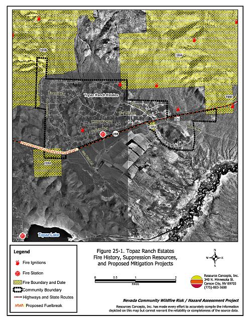
The Topaz Ranch Estates community is located in southern Douglas County along State Route 208, just east of the junction between US Highway 395 and State Route 208. The community is primarily situated on a south-facing slope at the southern end of the Pine Nut Mountains and north of Wild Oat Mountain. Public lands border the community to the north and west, and National Forest to the south. Approximately 840 homes were observed in the community during the assessment. The hazard assessment resulted in classifying Topaz Ranch Estates in the High Hazard category (65 points). A summary of the factors that determine this hazard rating is included in Table 25-2. The primary conditions in the Topaz Ranch Estates community that affected the hazard score were the potential for hazardous fire behavior, many occurrences of inadequate defensible space, and the distance to water sources for fire suppression.
25.1.1 Community Design
The Topaz Ranch Estates interface area is characterized by the intermix wildland-urban interface condition. Structures are scattered throughout the wildland area with no clear line of demarcation between wildland fuels and residences in the community. In the intermix condition parcels are generally greater than one acre (see Figure 25-1).
- Roads: State Route 208 is the primary access route between the Topaz Ranch Estates community and other communities in Douglas County. Topaz Ranch Drive and Albite Road are the primary access roads for the community to access State Route 208. The roads are paved, usually greater than 24 feet wide, and provide adequate access for fire suppression vehicles. Most of the secondary community roads have adequate turn around space for fire suppression equipment. Approximately half of the community roads have a gradient greater than five percent.
- Signage: Street names are adequately identified with reflective lettering. Residential addresses were visible on a majority of the homes assessed; however, more than 100 homes did not have easily visible addresses. Clear and visible residential addresses are important to aid firefighting personnel in locating homes during low visibility conditions that occur during a wildland fire.
- Utilities: Overhead power lines are present within the community. Power line right-of-ways are not properly maintained in all cases, which increases the possibility of power lines sparking during windstorms and starting fires in nearby vegetation. Propane tanks are present throughout the community and in many cases lack the minimum ten feet of vegetation clearance.
25.1.2 Construction Materials
Almost all of the homes assessed were built with fire resistant siding materials and non-combustible roofing materials, mainly composition type roofing. About 38 percent of the homes observed have unenclosed balconies, porches, decks or other architectural features that create drafts and provide areas where sparks and firebrands can be trapped, smolder, ignite, and rapidly spread fire to the home.
25.1.3 Defensible Space
Sixty three percent of the homes observed in the interface have landscaping that would meet the minimum defensible space requirement to help protect the home from damage or loss during a wildfire. Several landowners have conducted additional fuel reduction treatments on entire lots.
25.1.4 Suppression Capabilities
Wildfire Protection Resources
Topaz Ranch Estates is provided wildland and structure fire protection by the East Fork Fire and Paramedic District’s Topaz Ranch Estates Volunteer Fire Department Station 4 (a combination career/volunteer station with two career members) and the Topaz Lake Volunteer Fire Department Station 5. The Topaz Ranch Estates VFD responded to 213 emergency calls in 2001. Station 4 actively works with the Topaz Ranch Estates community on the “Compost your Combustibles” and reflective address sign programs (East Fork Fire and Paramedic Districts website). See Tables 4-2 and 4-3 for more information on the typical fire suppression response for first-alarm wildland-urban interface fires in Douglas County. Appendix E lists the type and number of fire suppression vehicles located at each EFFPD and Douglas County VFD station.
BLM / Interagency wildland fire resources will respond to al wildland fire reports within the Topaz Ranch Estates community to protect adjacent public land and National Forest. The closest federal response would come from the Topaz Lake Guard Station. The response will be initiated by the Sierra Front Interagency Dispatch Center.
Water Sources and Infrastructure
Water availability for fire suppression in Topaz Ranch Estates includes one 210,000-gallon tank and one 660,000-gallon tank in the community. There is also one static 50,000 gallon tank near Penrod Lane in the Holbrook Junction Community. This tank is not connected to wells and must be filled each fire season. No emergency generators are available for the pumps that fill the tanks. Hydrants are available three miles from the community at Topaz Lodge in the Topaz Lake community. Topaz Lake may be used as a helicopter dip site and drafting source.
25.1.5 Factors Affecting Fire Behavior
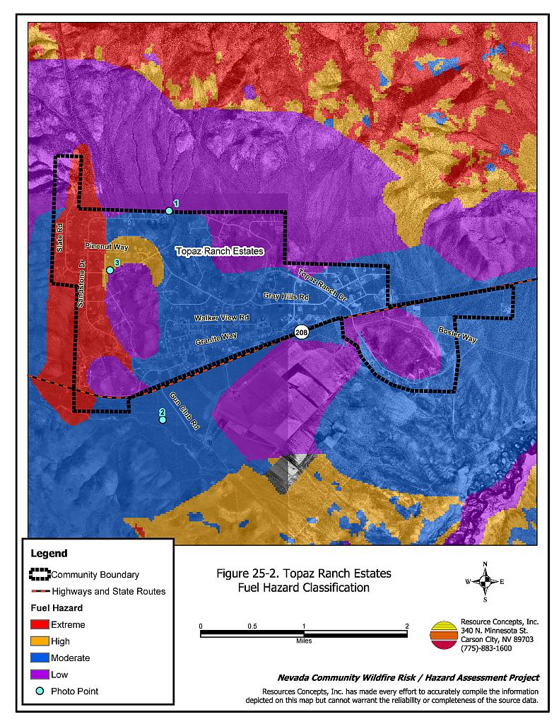
Vegetation, dead and down fuels, and topographic features contribute to the potential fire hazard around wildland-urban interface communities. The fuel hazards were mapped for Topaz Ranch Estates, and fuel hazard photos were taken to provide additional information for the vegetation type descriptions (see Figures 25-2 and 25-3).
The terrain within the Topaz Ranch Estates is gently sloping with average slopes of ten percent; however, in the north and northwest parts of the community, slopes exceed twenty percent. The fuel hazard in the Topaz Ranch Estates community ranged from low to extreme due to natural vegetation types and previously completed fuel reduction work within the community. Three fires have occurred within the community and have generally reduced the fuel hazard in these areas to a low hazard. In the burned areas, the vegetation primarily consists of widely spaced big sagebrush, rabbitbrush, bitterbrush, Mormon tea, Nevada ephedra, and spiny horsebrush, with understory grasses of crested wheatgrass and cheatgrass. In burned areas, the fuel load was estimated between one and two tons per acre. In other areas of the community, characterized by shallow soils, the vegetation consists of widely spaced, low sagebrush (less than one foot high) with traces of rabbitbrush and bitterbrush. The low hazard areas were estimated to have fuel loads less than one ton per acre.
The area where houses are located and the area south of State Route 208 had a moderate fuel hazard. Dominant vegetation consists of big sagebrush, Mormon tea, desert peach, bitterbrush, and rabbitbrush with bottlebrush squirreltail, cheatgrass, and basin wildrye in the understory. Some pinyon pine are scattered throughout this fuel type. Fuel loads were estimated between two and four tons per acre.
On the west side of the community the fuel hazard was considered extreme. The primary species present included big sagebrush, Mormon tea, desert peach, bitterbrush and rabbitbrush, with a dense overstory of pinyon pine. The fuel load was estimated to be ten to fifteen tons per acre.
Numerous fires have occurred within the vicinity of the community from both human and lightning causes. A 307-acre fire and the sixteen-acre Wildoat Fire occurred south of the community in 1994. A 9,833-acre fire also occurred northeast of the community in 1994. A 7,443-acre fire occurred in 1996, northwest of the community. Numerous other fires have occurred south of the community between 1950 and 1975. The predominant wind direction is from the south, especially in the late afternoon.
25.1.6 Fire Behavior Worst Case Scenario
The worst-case scenario for Topaz Ranch Estates would likely occur in the event of a lightning or human-caused ignition in the area of Granite and Brecca Streets. With south winds exceeding 25 miles per hour, a fire could rapidly spread north and upslope through the dense pinyon pine and sagebrush vegetation. Homes could be immediately threatened by fire. The scenario would be worse if volunteer fire department resources were unavailable at the time of ignition. A minimum of thirty minutes (and more likely one hour) is needed for career-department resources to respond to an emergency in the community. Many homes could be lost before fire suppression resources would have the opportunity to respond.
25.1.7 Ignition Risk Assessment
Topaz Ranch Estates has been rated with a high ignition risk, with lightning storms being the primary risk and the overhead power lines posing a secondary risk.
25.2 Risk and Hazard Reduction Recommendations
The Topaz Ranch Estates risk and hazard reduction recommendations focus on improving defensible space and promoting homeowner responsibilities Other recommendations pertain to community coordination efforts that could be initiated to enhance the fire safe nature of Topaz Ranch Estates.
25.2.1 Defensible Space Treatments
Property Owner Recommendations
Defensible space treatments are an essential first line of defense for residential structures. Significantly reducing or removing vegetation within a prescribed distance from structures (minimum of 30 feet to 200 feet depending upon slope and vegetative fuel type) reduces fire intensity and improves firefighter and homeowner chances for successfully defending a structure against an oncoming wildfire.
- Remove, reduce, and replace vegetation around homes according to the guidelines in Appendix D. This area should be kept:
- Lean: There are only small amounts of flammable vegetation,
- Clean: There is no accumulation of dead vegetation or other flammable debris,
- Green: Existing plants are healthy and green during the fire season.
- Maintain the area beneath unenclosed wood decks and porches free of weeds and flammabledebris. Enclose these areas wherever possible.
- Store firewood a minimum distance of thirty feet from structures.
- Clear all vegetation and combustible materials for a minimum of ten feet around propane tanks.
- Mow or remove brush growing within a distance of 25 feet and grasses growing within ten feet of wood fences in the community.
- Install spark-arresting screens on chimneys.
- Cheatgrass or other annual grasses that have become dominant within the defensible space zone should be mowed or treated with an application of pre-emergent herbicide prior to seed set. Treatments may need to be repeated the following year to ensure that the seed bank of unwanted grasses has been depleted. Refer to Appendix D for recommended seed mixes and planting guidelines that can be used in conjunction with removal of this annual grass.
- Thin pinyon trees in the defensible space area such that tree canopies are spaced a minimum distance of thirty feet from any other trees, shrubs, or residential structures. Limb remaining pinyon and juniper trees within the defensible space area to a minimum of four feet up from the ground, or no more than one-third the height of the trees. Reduce the needle and cone duff from under the remaining trees to a depth no greater than one-inch.
- Irrigate all trees and shrubs in close proximity to structures to increase their fire resiliency, especially during drought conditions.
- Immediately remove cleared vegetation to an approved disposal site when implementing defensible space treatments. This material dries quickly and presents a fire hazard if left on site.
- Maintain this defensible space as needed to keep the space lean, clean, and green.
25.2.2 Fuel Reduction Treatments
Fuel reduction treatments are applied on a larger scale than defensible space treatments. By permanently changing the fuel structure over large blocks of land to one of a lower volume or reduced flammability (a fuel reduction treatment), the expected result in the event of a catastrophic wildfire would be one of reduced capacity for uncontrolled spread through the treatment area.
Property Owner Recommendations
- Remove sagebrush within ten feet and pinyon pine within 25 feet on both sides of private driveways longer than 200 feet. Replace highly flammable shrubs and trees with fire-resistant species such as crested wheatgrass, lawn, or a pre-suppression seed mix. Appropriate seed mixtures and seeding specifications are provided in Appendix D.
- On all private lots with pinyon pine trees, reduce tree density for an additional 100 feet beyond the defensible space area. Trees should be thinned such that canopies are spaced two times the height of the trees. Remove ladder fuels (shrubs and grasses) within ten feet of all tree drip lines. Limb pinyon trees a minimum of four feet from the ground, or no more than one-third the height of the trees. Coordinate with EFFPD for assistance with homeowner cooperation and biomass removal programs.
- Coordinate with EFFPD to construct and maintain a 200-foot wide fuelbreak (100-feet each side of State Route 208) for a distance of approximately one mile on the south side of the community, for a total treatment of approximately 23 acres (see Figure 25-1). Thin trees to a maximum density of ten trees per acre within the first fifty feet on both sides of the road. For an additional fifty feet thin trees so that the distance between tree canopies is equal to twice the height of the trees. Thin shrubs to a canopy spacing twice the height of the shrubs and remove all shrubs within ten feet of tree canopies.
East Fork Fire and Paramedic Districts Recommendations
- Coordinate with property owners to construct a 200-foot wide fuelbreak (100-feet each side of State Route 208) for a distance of approximately one mile on the south side of the community, for a total treatment of approximately 23 acres (see Figure 25-1). Thin trees to a maximum density of ten trees per acre within the first fifty feet on both sides of the road. For an additional fifty feet, thin trees so that the distance between tree canopies is equal to twice the height of the trees. Thin shrubs to a canopy spacing of twice the height of the shrubs and remove all shrubs within ten feet of tree canopies.
- Coordinate with homeowners to construct and maintain fuels reduction treatments on all private parcels with a pinyon pine trees.
- The biomass generated from construction of the fuelbreak and other fuel reduction treatments should be removed and disposed of at an appropriate site. The fuelbreak should be maintained such that there is no significant increase in shrub and tree density from post-treatment levels.
Douglas County Roads Department Recommendation
- Remove pinyon trees, shrubs, and weeds for a distance of 25 feet on each side of roads in the community. For an additional 25 feet on each side of the road, reduce pinyon pine density to less than ten trees per acre.
Utility Company Recommendation
- Remove pinyon pine and shrubs within fifteen feet of power poles and power lines throughout the Topaz Ranch Estates community.
25.2.3 Community Coordination
Many of the most effective activities aimed at reducing the threat of wildfire for the Topaz Ranch Estates community require that individual property owners coordinate with each other and with local fire authorities. Defensible space, for example, is more effective in small communities when applied uniformly throughout entire neighborhoods. Public education and awareness, neighbors helping neighbors, and proactive individuals setting examples for others to follow are just a few of the approaches that will be necessary to meet the fire safe goals in the community. Disposal of biomass generated from defensible space and fuel reduction treatments can sometimes be most efficiently handled through community programs.
Property Owner Recommendations
- Assure that address signs are visible from the road. Address characters should be at least four inches high, reflective, and composed of non-flammable material. Improving visibility of addresses will make it easier for those unfamiliar with the area to navigate under smoky conditions during a wildland fire.
- Form a local chapter of the Nevada Fire Safe Council. The Nevada Fire Safe Council proposes to work on solutions that reduce the risk of loss of lives and property from wildfires in Nevada’s communities. Through establishment of a local Chapter, communities become part of a large information-sharing network that receives notifications of programs and funding opportunities for fire mitigation projects such as those listed in this report. The Nevada Fire Safe Council will accept and manage grants and contracts on the Chapter’s behalf through its non-profit status. The Nevada Fire Safe Council provides assistance and support to communities to complete fire safe plans, set priorities, educate and train community members, and promote success stories of its members. For more information on forming a chapter, contact:
Nevada Fire Safe Council
1187 Charles Drive
Reno, Nevada 89509
www.nvfsc.org
East Fork Fire and Paramedic Districts Recommendation
- Distribute copies of the publication “Living With Fire” to all property owners who live in Topaz Ranch Estates. This publication is free of charge. Copies can be requested from the University of Nevada Cooperative Extension.
25.3 Summary of Recommendations
| Involved Party | Recommended Treatment | Recommendation Description |
|---|---|---|
| Property Owners | Defensible Space | Remove, reduce, and replace vegetation around home according to the defensible space guidelines in Appendix D. |
| Fuels Reduction | Reduce vegetative fuels for a distance of ten feet on both sides of private driveways longer than 200 feet. Coordinate with EFFPD to conduct fuels reduction treatments. On all private lots with pinyon pine trees, reduce tree density for an additional 100 feet beyond the defensible space area. Trees should be thinned such that canopies are spaced two times the height of the trees. Coordinate with the NEFFPD to implement fuel reduction on all private parcels with pinyon trees. Coordinate with EFFPD to construct shaded fuelbreak along State Route 208. |
|
| Community Coordination | Assure that address signs are visible from the road. Address characters should be at least four inches high, reflective, and composed of non-flammable material. Form a local chapter of the Nevada Fire Safe Council. |
|
| Douglas County | Fuels Reduction | Remove pinyon/juniper trees, shrubs, and weeds for a distance of 25 feet on each side of roads in the community. For an additional 25 feet on each side of the road, reduce pinyon pine density to less than ten trees per acre. |
| Utility Company | Fuels Reduction | Remove trees or trim any branches within fifteen feet of either side of power lines and poles throughout the Topaz Ranch Estates community. |
| East Fork Fire and Paramedic Districts | Fuels Reduction | Coordinate with property owners to construct a 200-foot wide fuelbreak (100-feet each side of State Route 208) for a distance of approximately one mile on the south side of the community, for a total treatment of approximately 23 acres (see Figure 25-1). Coordinate with property owners to implement fuels reduction treatments on all private parcels with a pinyon pine tree canopy layer. |
| Community Coordination | Distribute copies of the publication “Living With Fire” to all property owners. |
Table 25-2Topaz Ranch Estates Wildfire Hazard Rating Summary |
 |
Figure 25-1Topaz Ranch Estates Fire History, Suppression Resources, and Proposed Mitigation Projects |
 |
Figure 25-2Topaz Ranch Estates Fuel Hazard Classification |
 |
Figure 25-3. Topaz Ranch Estates Fuel Hazard Photo Points

Photo Point 1. Topaz Ranch Estates. 4292177N, 0281197E, 20°NE. Low sagebrush and traces of rabbitbrush and bitterbrush were widely spaced and less than one foot in height on shallow soils. The fuel loads were estimated at less than one ton per acre and considered a low fuel hazard.

Photo Point 2. Topaz Ranch Estates. 4288925N, 0281099E, 280°W. The fuel hazard within a majority of the area where houses are located and south of State Route 208 was considered moderate. Dominant vegetation consists of big sagebrush, Mormon tea, desert peach, bitterbrush, and rabbitbrush with bottlebrush squirreltail, cheatgrass, and basin wildrye in the understory. Some pinyon pine are scattered throughout this fuel type. Fuel loads were estimated between two and four tons per acre in this area.
Photo Point 3. Topaz Ranch Estates. 4291253N, 0280278E, 300°NW. On the west side of the community the fuel hazard was considered extreme. The dominant species include big sagebrush, Mormon tea, desert peach, bitterbrush and rabbitbrush, with a dense overstory of pinyon pine. The fuel load was estimated to be ten to fifteen tons per acre.