![]()
![]()
13.0 Genoa
13.1 Hazard and Risk Assessment
The town of Genoa is located in the northwest portion of Douglas County along Foothill Road (State Route 206) at the base of the Carson Range. The town of Genoa (historically Mormon Station) is considered the oldest town in the state of Nevada. The Genoa community includes the incorporated town of Genoa, homes and subdivisions located adjacent to the town boundaries, and the Genoa Lake Estates. Approximately 200 residences were assessed in the Genoa wildland-urban interface areas. The hazard assessment resulted in classifying the Genoa community in the High Hazard category (72 points). Summaries of the factors that determine these hazard ratings are included in Table 13-2. The high hazard rating is attributed to the large number of homes with inadequate defensible space and address identification as well as high and extreme hazard fuel conditions and potential for hazardous fire behavior.
13.1.1 Community Design
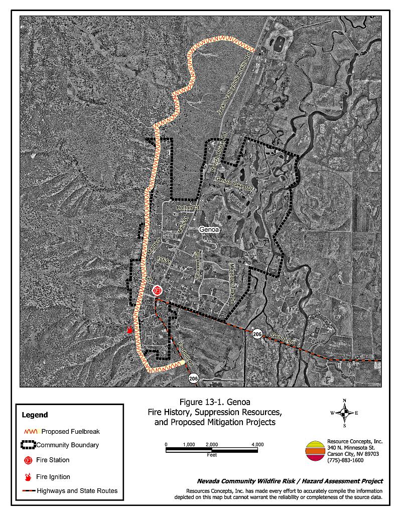
Genoa is a community with both intermix and classic wildland-urban interface conditions. The intermix condition is described as structures scattered throughout the wildland area with no clear line of demarcation between wildland fuels and residential structures in the community. In the areas of classic interface condition, homes border wildland fuels with a clear line of demarcation between the fuels and the residences. Most of the residences observed in Genoa were on parcels of between one and ten acres. See Figure 13-1 for a detailed graphic of the community.
- Roads: Foothill Road (State Route 206) and Genoa Lane are the primary roads connecting Genoa with other towns in Douglas County. These primary access roads are all at least 24 feet wide, paved, and have adequate turnaround space for fire suppression equipment. The secondary roads in the older sections of town are generally narrow and may limit fire suppression equipment maneuverability and two-vehicle passage; however, the roads end with adequate turnaround space and road grades are generally less than five percent.
- Signage: A majority of streets had signs that were easily visible from the road. Addresses were visible only on approximately two-thirds of the homes. Clear and visible street signs and residential addresses are important to aid firefighting personnel in locating at risk areas of a community during low visibility conditions that occur during a wildfire.
- Utilities: Utilities were a combination of above ground and below ground power. Power line corridors have not been properly maintained. Vegetation clearance is needed to minimize wildfire damage to electric utilities and reduce the possibility that sparks created by electric utilities could start a fire in adjacent vegetation.
13.1.2 Construction Materials
Ninety-five percent of the homes in the Genoa interface were built with treated wood siding materials, stucco, vinyl, brick, or other fire resistant siding materials. Ninety-two percent of homes had fire-resistant roofing materials such as composition roofing or metal. Approximately twenty percent of the homes observed have unenclosed balconies, porches, decks or other architectural features that create drafts and provide areas where sparks and firebrands can be trapped, smolder, ignite, and rapidly spread fire to the home.
13.1.3 Defensible Space
Approximately forty percent of the homes assessed in the Genoa wildland-urban interface had defensible space within the minimum recommended distance depending upon slope and vegetative fuel type to help protect the home from damage or loss during a wildfire.
13.1.4 Suppression Capabilities
Wildfire Protection Resources
The Genoa Volunteer Fire Department (Station 3) of the East Fork Fire and Paramedic Districts provides structure and wildland fire protection to the town of Genoa. Station 3 responded to 104 calls in 2000 (East Fork Fire Protection District website). See Tables 4-2 and 4-3 for more information on the typical fire suppression response for first-alarm wildland-urban interface fires in Douglas County. Appendix E lists the type and number of fire suppression vehicles located at each EFFPD and Douglas County VFD station.
Water Sources and Infrastructure
Hydrants are available within 1,000 feet of residences in the town of Genoa and the Genoa Lakes subdivision. However, hydrants are not available for older homes on the west side of the community and residences on the ranches and ranchettes on the east side of the community. Two tanks with a cumulative capacity of 850,000 gallons supply the hydrant system and are available for drafting sources. No emergency generators are available for the well pumps that supply the tanks. Possible helicopter dip sites include the Carson River and golf course water hazards.
13.1.5 Factors Affecting Fire Behavior
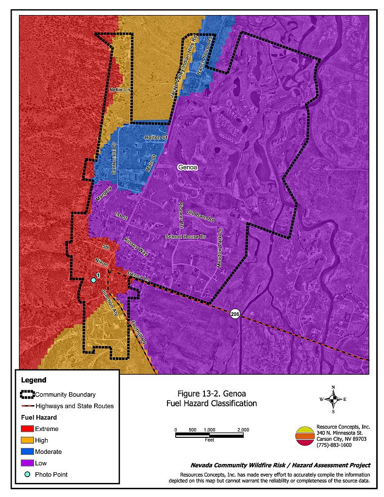
Vegetation, down and dead fuels, and topography contribute to the potential fire hazard around wildland-urban interface communities. The fuel hazards were mapped for Genoa and fuel hazard photos were taken to illustrate the relationship between vegetation types, slope, aspect, and overall fuel hazard (see Figures 13-2 and 13-3). The town of Genoa is situated at 4,800 feet at the base of the eastern-slope of the Carson Range. Steep canyons including Sierra, Schoolhouse, and Genoa Canyons lie directly west of the community. Predominant winds are from the south and downslope from the west. Slopes within the community range between two and 25 percent.
The predominant vegetation types on the west side of Genoa are Jeffrey pine/bitterbrush/ sagebrush, bitterbrush/sagebrush, sagebrush/perennial grass, and irrigated pastureland. The irrigated pastureland and Carson River riparian areas border the east and southeast sides of the community. In the Jeffrey Pine vegetation type on the west side of the community, rabbitbrush, bitterbrush, big sagebrush, and desert peach were the primary shrubs with cheatgrass and perennial grass ground fuels. The fuel load was estimated at four to sixteen tons per acre and considered an extreme fuel hazard. The irrigated pastureland and riparian areas were considered a low fuel hazard.
In the bitterbrush/sagebrush vegetation type along the southwest side of the community, the dominant shrubs species included big sagebrush, bitterbrush, desert peach, elderberry, and mountain mahogany with a grass understory of cheatgrass, bottlebrush squirreltail, and Sherman big bluegrass. Shrub heights ranged between two and eight feet in height. The fuel load was estimated at five to six tons per acre and was considered an extreme fuel hazard due to the vertical and horizontal continuity of the fuel.
In the sagebrush/perennial grass vegetation type, located at the south end of the community, big sagebrush, bitterbrush, and mountain mahogany were the dominant shrub species with bottlebrush squirreltail, cheatgrass, and bluegrass species comprising the ground fuels. The fuel load in this type was estimated at four to six tons per acre and considered a high fuel hazard.
The native vegetation surrounding homes in the Genoa Lakes subdivision consisted of big sagebrush, bitterbrush, and rabbitbrush with a cheatgrass understory. Fuels were estimated to range between two and four tons per acre and were considered a moderate fuel hazard.
A large percentage of the land surrounding homes on the east side of Genoa was irrigated agricultural land, which serves as a greenstrip for the community. The vegetative fuels were considered to be light with an estimated fuel load of less than one ton per acre. Due to the annual (or more frequent) harvest of the vegetation, and the irrigated, fire-resistant, qualities of the vegetation these lands were rated as a low fuel hazard.
13.1.6 Fire Behavior Worst Case Scenario
The area surrounding Genoa has an extensive wildfire history, primarily from dry lightning strikes during summer thunderstorms. A 250-acre fire occurred on the west side of the community in 1957 and another 316-acre fire occurred in 1984 less than one-mile south of Genoa. The worst-case scenario for the community would likely involve a dry lightning storm in the afternoon of a high hazard day. If an ignition were to occur on the east-facing slope, west of Genoa, strong, westerly downslope winds greater than 25 miles per hour could push the fire downslope through brush and timber. A crown fire could quickly threaten residences and businesses in town. This situation would be worse if it were to occur during one of the many events like the Candy Dance and Fourth of July when several thousand tourists are in town. Fire suppression resources could be delayed and evacuation could be extremely difficult if these situations were to occur simultaneously.
13.1.7 Ignition Risk Assessment
Genoa has a high potential for ignition due to wildfire and ignition history, and a high potential for structure loss due to dense vegetation, heavy fuel loads, and mountainous topography. The primary ignition risk in Genoa is lightning, although human caused ignitions are unpredictable and can occur at any time.
13.2 Risk and Hazard Reduction Recommendations
The Genoa risk and hazard reduction recommendations address the primary concern regarding protection of existing and future development in the wildland-urban interface area. Other recommendations pertain to community coordination and public education efforts that could be undertaken to enhance fire safety in Genoa.
13.2.1 Defensible Space Treatments
Defensible space treatments are an essential first line of defense for residential structures. Significantly reducing or removing vegetation within a prescribed distance from structures (30 to 200 feet depending upon slope and vegetative fuel type) reduces fire intensity and improves firefighter and homeowner chances for successfully defending a structure against an oncoming wildfire.
Property Owner Recommendations
- Remove, reduce, and replace vegetation around homes according to the guidelines in Appendix D. This area should be kept:
- Lean: There are only small amounts of flammable vegetation,
- Clean: There is no accumulation of dead vegetation or other flammable debris,
- Green: Existing plants are healthy and green during the fire season.
- Maintain this defensible space as needed to keep the space lean, clean, and green.
- Immediately remove cleared vegetation to an approved disposal site when implementing defensible space treatments. This material dries quickly and presents a fire hazard if left on site.
- Maintain the area beneath unenclosed wood decks and porches free of weeds and flammabledebris. Enclose these areas wherever possible.
- Clear all vegetation and combustible materials around propane tanks for a minimum distance of ten feet.
- Mow or remove brush growing within 25 feet of wood fences in the community and grass within ten feet.
- Store firewood a minimum distance of thirty feet from structures.
- Install spark-arresting screens on chimneys.
- Annually remove vegetation and debris along irrigation ditches to reduce the fuel load.
- Remove pine needles, leaves, and debris from roofs and rain gutters.
- Prune tree branches within fifteen feet of chimneys and structures.
- Limb branches of conifers a minimum of fifteen feet up from the ground, or no more than one-third of the total tree height to reduce ladder fuels. All dead and diseased branches and duff should be removed from beneath remaining trees.
- Irrigate all trees and large shrubs in close proximity to structures to increase their fire resiliency, which is especially important during drought conditions.
- Cheatgrass or other annual grasses that have become dominant within the defensible space zone should be mowed or treated with an application of pre-emergent herbicide prior to seed set. Treatments may need to be repeated the following year to ensure that the seed bank of unwanted grasses has been depleted. Refer to Appendix D for recommended seed mixes and planting guidelines that can be used in conjunction with removal of this annual grass.
13.2.2 Fuel Reduction Treatments
Fuel reduction treatments are applied on a larger scale than defensible space treatments. By permanently changing the fuel structure over large blocks of land to one of lower volume or reduced flammability (a fuel reduction treatment), the expected result in the event of a catastrophic wildfire would be one of reduced capacity for uncontrolled spread through the treatment area.
Property Owner Recommendations
- Reduce vegetative fuels for a distance of ten feet on both sides of private driveways longer than 200 feet. Remove highly flammable shrub species and replace with fire-resistant species such as crested wheatgrass, lawn, or a pre-suppression seed mix. Recommended seed mixtures and seeding specifications are provided in Appendix D.
- Coordinate with EFFPD and the US Forest Service to construct and maintain a proposed fuelbreak on the west side of the community.
East Fork Fire and Paramedic Districts and US Forest Service Recommendations
- Coordinate with property owners to construct a 400-foot wide shaded fuelbreak for a distance of approximately four miles on the west side of the community, for a total treatment of approximately 185 acres (see Figure 13-1). Remove small trees and shrubs within thirty feet of tree driplines. For shrubs outside the drip line, thin shrubs to a canopy spacing twice the height of the shrubs. Thin trees stands to a minimum basal area of 60 to 80 sq. ft. per acre. For example, where trees in the stand are of an average diameter of 14 inches (DBH), tree spacing should be reduced to approximately 65 trees per acre, with a minimum spacing of 25 feet between tree boles. If the average diameter of trees in the stand is 24 inches (DBH), tree spacing should be reduced to 22 trees per acre, with a minimum spacing of 45 feet between tree boles. Prune lower limbs within fifteen of the ground, but do not remove limbs from more than one-third the height of the tree. Refer to Appendix D for more information on tree spacing between boles for various basal areas and tree diameters.
- The biomass generated from construction of the fuelbreak should be removed and disposed of at an appropriate site (piled and burned or transported off the site). The fuelbreak should be managed and retreated as necessary to maintain the desired plant density and spacing.
Douglas County Recommendation
- Remove brush for a distance of 25 feet on the west side of Foothill Road from Jacks Valley Road south to Fairview Lane. Remove all shrubs with mechanical mastication equipment, and plant fire-resistant perennial grasses and wildflowers. Appropriate seed mixtures and seeding specifications are provided in Appendix D.
Utility Company Recommendation
- Remove trees or trim any branches within fifteen feet of either side of power lines and poles throughout Genoa.
13.2.3 Community Coordination
Many of the most effective activities aimed at reducing the threat of wildfire for the Genoa community require that individual property owners coordinate with each other and with local fire authorities. Defensible space, for example, is more effective in small communities when applied uniformly throughout entire neighborhoods. Public education and awareness, neighbors helping neighbors, and proactive individuals setting examples for others to follow are just a few of the approaches that will be necessary to meet the fire safe goals in the community. Disposal of biomass generated from defensible space and fuel reduction treatments can sometimes be most efficiently handled through community programs.
Property Owner Recommendations
- Assure that address signs are visible from the road. Address characters should be at least four inches high, reflective, and composed of non-flammable material. Improving visibility of addresses will make it easier for those unfamiliar with the area to navigate under smoky conditions that can occur during a wildland fire.
- Form a local chapter of the Nevada Fire Safe Council. The Nevada Fire Safe Council proposes to work on solutions that reduce the risk of loss of lives and property from wildfires in Nevada’s communities. Through establishment of a local Chapter, communities become part of a large information-sharing network that receives notifications of programs and funding opportunities for fire mitigation projects such as those listed in this report. The Nevada Fire Safe Council will accept and manage grants and contracts on the Chapter’s behalf through its non-profit status. The Nevada Fire Safe Council provides assistance and support to communities to complete fire safe plans, set priorities, educate and train community members, and promote success stories of its members. For more information on forming a chapter, contact:
Nevada Fire Safe Council
1187 Charles Drive
Reno, Nevada 89509
www.nvfsc.org
East Fork Fire and Paramedic Districts Recommendation
- Distribute copies of the publication “Living With Fire” to all property owners who live in Genoa. This publication is free of charge. Copies can be requested from the University of Nevada Cooperative Extension.
13.3 Summary of Recommendations
| Involved Party | Recommended Treatment | Recommendation Description |
|---|---|---|
| Property Owners | Defensible Space | Remove, reduce, and replace vegetation around homes according to the defensible space guidelines in Appendix D. |
| Fuels Reduction | Reduce vegetative fuels for a distance of ten feet on both sides of private driveways longer than 200 feet. Coordinate with the EFFPD and the US Forest Service to construct and maintain a fuelbreak on the west side of the community. |
|
| Community Coordination | Assure that address signs are visible from the road. Address characters should be at least four inches high, reflective, and composed of non-flammable material. Form a local chapter of the Nevada Fire Safe Council. |
|
| US Forest Service East Fork Fire and Paramedic Districts |
Fuels Reduction | Coordinate with property owners to construct and maintain a 400-foot wide fuelbreak on the west side of the community. |
| Community Coordination | Distribute copies of the publication “Living With Fire” to all property owners. | |
| Douglas County | Fuels Reduction | Remove brush for a distance of 25 feet on the west side of Foothill Road from Jacks Valley Road south to Fairview Lane. |
| Utility Company | Fuels Reduction | Remove trees or trim any branches within fifteen feet of either side of power lines and poles throughout Genoa. |
Table 13-2Genoa Wildfire Hazard Rating Summary |
 |
Figure 13-1Genoa Fire History, Suppression Resources, and Proposed Mitigation Projects |
 |
Figure 13-2Genoa Fuel Hazard Classification |
 |
Figure 13-3. Genoa Fuel Hazard Photo Points

Photo Point 1. Genoa Fuel Hazard Photo Point. 4320950N, 0253402E, 285°W. On the west side of Genoa the vegetation consists of Jeffrey pine with an understory of bitterbrush, big sagebrush, and desert peach. The fuel load was estimated at four to sixteen tons per acre and considered an extreme fuel hazard.