![]()
![]()
6.0 Kyle Canyon
6.1 Risk and Hazard Assessment
Kyle Canyon is located on the east side of Mt. Charleston in the Spring Mountains, approximately forty miles northwest of Las Vegas. The surrounding terrain is steep and highly dissected. The majority of the housing in the community occurs at the upper end of a narrow canyon. A total of 335 homes were observed for the hazard assessment in the Kyle Canyon community. The assessment resulted in classifying Kyle Canyon in the Extreme Hazard category (95 points). The rating is primarily attributed to limited access, poor defensible space, the potential for extreme fire behavior, and structures without fire resistant building materials. Table 6-3 at the end of this section presents a summary of the community hazard rating values for Kyle Canyon.
6.1.1 Community Design
The area surrounding the Kyle Canyon community is characterized as a rural interface condition with small, scattered clusters of structures surrounded and separated by wildland fuels. Each lot observed in the community was smaller than one acre in size indicating high density housing.
- Access: The primary access into Kyle Canyon is State Route 157, a paved two-lane road that is between 20 and 24 feet wide. The road extends twenty miles from US Highway 95. This is the only access road into and out of the canyon. In places, the road grade is greater than five percent, which could be problematic for heavy water tenders and engines. The base of the canyon may also be reached via State Route 158 from Lee Canyon. Many secondary roads are paved but generally do not provide adequate room for fire suppression equipment to maneuver. Access for emergency response is further limited in the summer due to highly congested traffic and limited parking available for tourists who currently park along the roadsides.
- Signage: Street signs are visible on approximately half of the roads in the community. Residential addresses are visible on about 75 percent of the homes in the community. Clear and visible street signs and residential addresses are important to aid firefighters in locating homes during low visibility conditions that occur during a wildland fire.
- Utilities: Utilities are a moderate ignition risk. Many areas within power line corridors and around transformers are in need of vegetation clearing and thinning.
6.1.2 Construction Materials
Approximately 95 percent of the homes in the interface area are built with non-combustible roofing materials, but only twenty percent of the homes have fire resistant siding materials. Approximately seventy percent of the homes observed have unenclosed balconies, decks, porches, eaves, or attic vents that can create drafty areas where sparks and embers can be trapped, smolder, ignite, and rapidly spread fire to the house.
6.1.3 Defensible Space
None of the 355 homes assessed within the Kyle Canyon area met the minimum requirements for defensible space landscaping to minimize damage or loss of homes and other structures during a wildfire. The defensible space requirement is based on vegetation and slope as illustrated in Appendix E. The recommended defensible space zone throughout the Kyle Canyon community is 100-200 feet wide at a minimum. The terrain is steep, with heavy tree and shrub vegetation in close proximity to the homes. Many homes are in direct contact with tree branches or have trees that overhang roofs and decks.
6.1.4 Suppression Capabilities
Wildfire Protection Resources
The Nevada Division of Forestry administers a 1,800-acre NRS 473 fire protection district on Mount Charleston. The Mount Charleston Fire Protection District includes 400-500 homes in Kyle and Lee Canyons, a school, and commercial and community buildings. The Nevada Division of Forestry Fire Station in Kyle Canyon provides 24-hour, continuous coverage with a three-person engine company. Staffing is increased seasonally with the addition of a Type III wildland engine crew from April to September.
Clark County Rural Fire Station 81 is located in Kyle Canyon, providing services for a volunteer fire department with twenty members. The US Forest Service staffs the Kyle Station seasonally with crews and equipment for wildland fire incidents.
Fire apparatus assigned to Kyle Canyon is summarized in Table 6-1 based on data available at the time of interviews with local and regional fire authorities.
| Type of Resource | Amount of Equipment | Cooperating Partner (Resource Location) |
|---|---|---|
| Type 1 Structure Engine Type 6 Quick Attack Engine Basic Life Support (BLS) Rescue |
1 1 1 |
Clark County Rural Fire Station 81 (Kyle Canyon) |
| Type 3 Brush Engine Type 4 Brush Engine Type 7 Brush Patrol Engine |
1 1 1 |
US Forest Service (Kyle Station 81 - seasonal) |
| Type 1 Structure Engine Type 3 Brush Engine |
1 1 |
Nevada Division of Forestry (Kyle Fire Station) |
| Source: Steve McClintock, Dave Bibee and Steve Brittingham, pers. comm. 20 March 04 | ||
Additional county resources would be dispatched through the Clark County Fire Alarm office.
Fire suppression resources administered by federal agencies such as the US Forest Service are listed according to their local assigned area. It is important to note that these apparatuses are considered national resources and are commonly reassigned to areas of higher severity during the fire season. In response to a wildland fire call, interagency dispatch centers locate and dispatch the closest available resource according to incident command and computer-aided dispatch protocols.
Water Sources and Infrastructure
Water available for fire suppression in the Kyle Canyon community includes fire hydrants within 500 feet of structures with a minimum flow capacity of 500 gallons per minute. The water system includes two storage tanks totaling almost 200,000 gallons in the Rainbow subdivision; one water storage tank with 100,000 gallons capacity in the Echo subdivision; one water storage tank with 100,000 gallons capacity at the Mt. Charleston Hotel; and one water storage tank with 25,000 gallons capacity at Mt. Charleston Lodge. An additional 300,000-gallon water storage tank is under construction in the Echo subdivision. Five ponds at three different locations have been identified as dip/drafting sites.
Fire Protection Personnel Qualifications
Volunteer and career firefighters who would respond to a wildfire near Kyle Canyon have a minimum of NFPA Firefighter I and II training and a limited number have had some wildland firefighting training (NWCG 310-1). The Nevada Division of Forestry and US Forest Service personnel meet minimum requirements per NWCG 310-1.
Work Load
The Nevada Division of Forestry responded to 200 emergency medical calls and thirty wildland brush fire calls in 2003. The Clark County Fire Department responded to 37 emergency medical calls and eight wildland brush fire calls in 2003.
Detection and Communication
There are no fire lookouts in the Mt. Charleston area but there are reconnaissance flights during high-risk periods. Nevada Division of Forestry and the Clark County Fire Department communication systems are compatible with neighboring agencies and there are no gaps in the radio coverage. There are no community sirens for early warnings.
Financial Support
Funding for Clark County Fire Department annual operating expenses comes from the County General Fund, which is generated primarily through property taxes. Nevada Division of Forestry fire protection is contracted with Clark County.
Community Preparedness
Clark County has an active Local Emergency Planning Committee and has adopted an all-risk, multi-agency emergency plan. The plan is reviewed annually and updated as needed.
The Nevada Division of Forestry has a fire suppression pre-attack plan for the Kyle Canyon area. It is updated as needed.
Clark County Fire Department and the Nevada Division of Forestry review development plans to ensure compliance with the UFC 1997 fire code. The Nevada Division of Forestry also requests voluntary compliance with defensible space guidelines.
6.1.5 Factors Affecting Fire Behavior
The lower reach of Kyle Canyon along State Route 157, below the intersection with State Route 158, is dominated by cliffrose and bursage, estimated at approximately two to three tons per acre. Ground fuels consist of annual grasses. The fuels are generally continuous with cliffrose reaching approximately six feet in height. The fuel hazard was considered extreme.
Further up the canyon ponderosa pine, mountain mahogany, white fir, aspen, and Gambel’s oak are added to the fuel load. Extensive accumulations of dead wood occur throughout the wooded area. Mountain mahogany is extremely dense and tall with abundant dead material persisting on most plants. The Rainbow and Echo Subdivision areas are located near the upper part of a long narrow canyon, within this woody fuel type.
The canyon topography can act as a natural chimney, drawing fire toward these neighborhoods. The steep slopes in this area are commonly covered with continuous fuels that pose a serious threat due to their close proximity to structures. Southern aspects, such as are found in Echo Subdivision, and northern aspects, as the Old Town Lodge site, are present in this canyon community.
At higher elevations in Kyle Canyon, vegetation is characterized with heavy fuels such as pinyon, juniper, and chaparral. The Spring Mountain Correctional Youth Camp, east of State Route 158, is located in a saddle where two drainages converge at a ridgeline. This topographic location presents conditions conducive to frequent winds. Prevailing winds in this area are from the south and southwest. The area has continuous fuels on steep (sixty to eighty percent), south facing slopes. Angel Peak, to the east of the Spring Mountain Youth Camp, has the same vegetation.
6.1.6 Fire Behavior Worst-Case Scenario
The Kyle Canyon area has been described as a disaster waiting to happen. Two general worst-case scenarios are described for the Kyle Canyon community. A third worst-case scenario is described for the Spring Mountain Youth Center and Angel Peak. The conditions for each scenario described would occur on a high visitor day (up to 10,000 vehicle trips per day on weekends in June, July, and August [Grismanauskas, pers comm.]). Parked cars along the road further limit access.
In the first scenario, a dry lightning storm would result in multiple ignitions upslope (west or north) from the community. Fire would be rapidly driven into the community by afternoon down slope winds. Multiple fires could conceivably exceed initial attack capabilities. Additional resources would have difficulty reaching the area by road due to the large amount of traffic exiting the canyon.
In the second scenario, a wildfire ignition from a dry lightning storm or human carelessness would ignite a fire down slope (south and east) of the community. Initially the fire would be pushed down canyon by downslope winds. As the fire becomes larger, it would become a plume-dominated fire. The natural chimney effect of Kyle Canyon would cause the fire to move up canyon into the community.
In both of the above scenarios, evacuations and response of firefighting resources may be compromised because there is only one road leading into and out of the community. The existing safe zone is not large enough to accommodate the number of people present in the area on a weekend in the summer.
The worst-case scenario for the Spring Mountain Youth Center and Angel Peak area involves a dry lightning storm in the summer with multiple ignitions in the south drainage below the facility. Prevailing south to southwest winds would rapidly drive a fire up the natural chimney. Flame lengths from a crown fire could be in excess of 100 feet in the dense pinyon and juniper. Potential for a similar fire in the north drainage exists during dry lightning storms with strong erratic winds.
6.1.7 Ignition Risk Assessment
The majority of the developed area in Kyle Canyon has a high ignition risk. Ignition history for the area shows numerous lightning strikes and other ignitions. The presence of campgrounds and the high level of visitor traffic during the fire season also contribute to the high rating.
6.2 Risk and Hazard Reduction Recommendations
The Kyle Canyon area is highly vulnerable to catastrophic fire. It is essential that property owners take a proactive stance in protecting their property through the establishment of good defensible space around all structures and the implementation of fuels reduction treatments within and surrounding their neighborhoods. The Mt. Charleston Chapter of the Nevada Fire Safe Council is an excellent means for organizing these activities. Collaboration with Clark County, the Nevada Division of Forestry, and the US Forest Service is essential to continued installation of fuelbreaks in strategic areas. Annual updates to initial attack and fuels reduction plans are critical for improving and maintaining Kyle Canyon as a fire safe community.
6.2.1 Defensible Space
Vegetation density, type of fuel, and slope gradient around a home affect the potential fire exposure levels to the home. These conditions define the defensible space area required for individual homes. The goals of defensible space are to reduce the risk of property loss from wildfire by eliminating flammable vegetation near the home. In turn, this lowers the chances of a wildfire spreading onto adjacent properties and it aids firefighters in their efforts to protect property against an approaching wildfire. Guidelines for establishing and improving defensible space around residences and structures in the community are given below and described in greater detail in Appendix E.
Defensible space is especially important in Kyle Canyon because homes and other structures are amidst heavy wildland vegetative fuels characterized as extreme fuel hazards. Defensible space is the homeowner’s responsibility, and it is an essential first line of defense for saving lives and property during a catastrophic wildland fire.
Private Property Owners
- Remove, reduce, and replace vegetation around homes. Keep this area:
- Lean: There are only small amounts of flammable vegetation.
- Clean: There is no accumulation of dead vegetation or other flammable debris.
- Green: Existing plants are healthy and green during the fire season.
- Thin existing trees to maintain a minimum distance of thirty feet between tree crowns.
- Thin mountain mahogany, Gambel’s oak, and other shrubs and brush to a distance equal to twice their height.
- Prune and remove dead and diseased tree branches. For ponderosa pine and white fir, prune branches a minimum of fifteen feet from the ground, but not more than one-third of the total tree height. For pinyon and juniper, prune all branches minimum of four feet from the ground, not to exceed one-third of the total tree height.
- Thin shrubs and other brush to a distance equal to twice their height (crown to crown).
- Clear brush, weeds, and grasses from within a ten-foot wide strip along either side of driveways.
- Enclose wood decks and porches. If this is not possible, keep the area beneath wood decks and porches free of weeds and other flammable debris. Where possible, install screens around unenclosed overhangs.
- Clear vegetation and combustible materials from around propane tanks for a minimum of ten feet.
- Clear leaves and debris from roofs and rain gutters.
- Store firewood a minimum of thirty feet from structures.
- Mow or remove brush growing against fences in the community.
- Immediately remove all cleared vegetation to an approved disposal site. This material dries quickly and poses a fire risk if left on site.
- Where possible, irrigate trees and large shrubs that remain in close proximity to structures to increase their fire resiliency. This is especially important during drought conditions.
- Install screens over all exterior vents to prevent sparks from entering the attic and other areas inside the home.
- Ensure that all branches are at least fifteen feet from chimneys and other heat sources. Install spark arrestors or screens on fireplace and wood stove chimneys.
- Maintain defensible space annually.
Clark County Fire Department and Nevada Division of Forestry
- Ensure that Clark County Fire Department and Nevada Division of Forestry personnel are trained and made available to perform courtesy defensible space inspections with homeowners.
6.2.2 Fuels Reduction
Recommendations provided below focus on the reduction of fuels along local roadways and the development of fuelbreaks in key locations around the Kyle Canyon community. A shaded fuelbreak is a fuels reduction treatment that alters the spacing and arrangement of combustible fuels in areas where the current fuel arrangement could support a catastrophic wildfire. If properly maintained, a shaded fuelbreak can eliminate the continuity of fuels in the tree, shrub, and ground layers. As a result, the heat intensity and rate of spread of an oncoming wildfire can be reduced considerably, offering conditions where a fire can be more safely and effectively managed on the ground.
Shaded Fuelbreak and Fuel Reduction Treatment Guidelines
The following specifications apply to fuel reduction treatments in this chapter.
- Broadcast seed fuelbreak areas prior to fuel removal to enhance soil stabilization and the establishment of fire-resistant vegetation, and to prevent noxious weed invasions. Use a pre-suppression seed mixture appropriate for the local climate and soil conditions, such as the one recommended in Appendix E.
- Thin mountain mahogany, pinyon, and juniper trees to a spacing equivalent to twice the height of the trees.
- Thin ponderosa pine and white fir trees to a minimum spacing of twenty to forty feet between tree trunks depending on the diameter of the tree, equivalent to 80 to 100 square feet of basal area per acre. (Refer to Appendix E for guidelines on basal area.) Thinning can be performed in a traditionally even-spaced manner, or trees can be thinned into a cluster-mosaic at the direction of a professional forester.
- Thin trees from below - remove smaller ponderosa pine, Gambel’s oak, pinyon pine, and mountain mahogany from under old growth ponderosa pine.
- The Nevada Forest Practice Act restricts the use of heavy equipment on slopes greater than thirty percent. Consult with a professional forester form the Nevada Division of Forestry for technical assistance with marking trees for removal, permitting and special operations on steep slopes.
- Where trees are removed, cut stumps as close to the ground as possible, leaving no stump higher than four inches.
- For mature large conifers such as ponderosa pine and white fir, prune all branches from six to fifteen feet above the ground, but not more than one-third of the total tree height. For smaller conifers such as pinyon and juniper trees, limb all branches a minimum of four feet from the ground, not to exceed one-third of the total tree height.
- Prune and remove dead and diseased tree branches
- Keep the area within ten feet of pruned trees free of smaller trees, shrubs, duff, and other ladder fuels.
- Thin areas of dense brush to a spacing between shrub canopies equal to twice the shrub height. Further reduce the fuel volume by reducing shrubs to a height of eighteen inches or less.
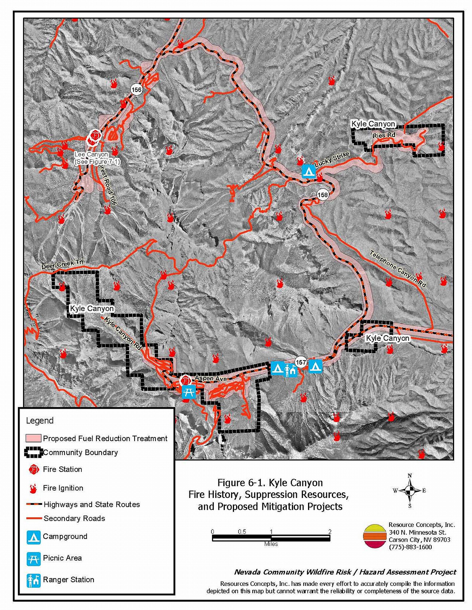
Details and locations for individual features are described below and illustrated in Figure 6-1.
Mt. Charleston Fire Safe Council Chapter, Old Town, Echo, and Rainbow Subdivisions
- Complete shaded fuelbreaks on each parcel, beginning at the bottom of the canyon and progressing towards the top. Extend the treatment area at least 300 feet beyond the perimeter of the developed parcels.
Clark County Fire Department, Nevada Division of Forestry, US Forest Service
- Construct and maintain a shaded fuelbreak along State Routes 157 and 158 for a width of 300 feet on the uphill side, and for 600 feet on the downhill side of the road. Remove all brush within twenty feet of State Route 157 on both sides of the road.
- Construct and maintain a shaded fuelbreak for a distance of 300 feet around the Kyle, Fletcher View, and Hilltop Campgrounds and the Cathedral Rock Day Use Area. Reduce vegetation within campgrounds, picnic areas, and all other concentrated public-use areas consistent with shaded fuelbreak guidelines.
- Construct and maintain a shaded fuelbreak 300 feet wide on the south side of the US Forest Service Ranger Station.
- Construct and maintain a shaded fuelbreak 600 foot wide along the downhill side of the access road from State Route 158 to the Spring Mountain Youth Camp.
- Construct and maintain a 600 foot wide shaded fuelbreak along both the south and north slopes below the Spring Mountain Youth Camp.
- Construct and maintain a shaded fuelbreak 300 feet wide around the radio radar facilities on Angel Peak east of the Spring Mountain Youth Center.
Utility Company
- Remove trees under utilities rather than topping the trees for power line clearance. Topping trees severely weakens them and predisposes them to attach by bark beetles. The fir engraver bark beetle (Scolytus ventralis) causes significant mortality in white fir.
- Clear all vegetation surrounding the electrical transfer station near the bottom of the canyon within thirty feet of the fence. Thin trees to a spacing equivalent to two times the height of the trees from crown to crown for an additional distance of 300 feet.
6.2.3 Community Coordination
Many of the most effective activities aimed at reducing the threat of wildfire require that individual property owners coordinate with each other and with local fire authorities. Defensible space, for example, is more effective in small communities when applied comprehensively throughout entire neighborhoods. Public education and awareness, neighbors helping neighbors, and proactive individuals setting examples for others to follow are just some of the approaches that will be necessary to meet the fire safe goals in the community.
Private Property Owners
- Ensure that address signs are visible from the road. Address characters should be at least four inches high, reflective, and composed of non-flammable material. Improving visibility of addresses will make it easier for those unfamiliar with the area to navigate under smoky conditions during a wildland fire.
- Work with the Nevada Division of Forestry, Clark County Fire Department, and Clark County Sheriff’s Department to identify any non-ambulatory persons within the community who may need evacuation assistance in the event of an emergency.
US Forest Service
- Close or extend the road off the east end of the Rainbow subdivision that dead-ends in a thickly wooded area between Rainbow and Highway 157. If it remains an un-gated dead end, there is a risk that it will mistakenly be taken for an escape route during a wildfire. Connecting it to Highway 157 will improve suppression resource access in a heavily wooded area.
Clark County Fire Department, Nevada Division of Forestry, and US Forest Service
- Prepare and distribute copies of the Kyle Canyon emergency evacuation plan to all residents, and post the plan throughout the community. Identify the names and addresses of all non-ambulatory persons within the community who need evacuation assistance. Conduct public workshops annually prior to the tourist/fire season to assure that all residents are fully knowledgeable of evacuation routes, evacuation procedures, designated fire safe zones, and procedures for deploying fire shelters if evacuation becomes infeasible during a fast moving fire storm.
- Complete the installation of a community siren to be used as an alarm call for evacuation.
- Develop and maintain helicopter dip sites for water storage or secure agreements to use existing wells or ponds as water sources for fire suppression.
- Identify or develop fire safe zones and fire safe structures for people to use if they are trapped in the canyon during a wildfire. These areas could include the fire stations, library, school, and a cleared area directly above the community (at least two acres in size). Limit the number of people (residents and tourists) in the canyon on high hazard days according to the capacity of the safety zones (use the estimated capacity of all identified fire safe zones and structures to determine the total number of people allowed in the canyon on a given summer day). Use the Fire Marshall’s building capacity when estimating the number of people allowed in structures identified as fire safe.
- Post “No Parking” signs and enforce limited parking along the roadway in areas where roadside parking would restrict emergency access. Locate alternative parking areas for crowded conditions or provide a shuttle service from the bottom of the canyon where more room is available for a public parking area.
- Create turnarounds with a minimum radius of seventy feet and adequate clearance on either side of access roads for large fire engines and other fire apparatus.
Clark County
- Ensure cooperation between the Assessor’s Office and the Roads Department to ensure that all roads in new developments are named, mapped, and identified with GPS locations.
- Develop county ordinances that enforce the implementation and maintenance of defensible space, and address fuels reduction responsibilities for absentee homeowners and vacant lots.
6.2.4 Public Education
Public distribution of general information on safety in high fire-risk environments and dissemination of information regarding evacuation plans and with fire safe zones is essential to help residents and property owners in Kyle Canyon make informed decisions prior to and during a wildfire. A program that explains fire safe measures in clear and emphatic terms will have an impact on residents in the wildland-urban interface: informed community members will be more inclined to take actions to effectively reduce fuels and other wildfire hazards around their home and in their neighborhoods.
Clark County Fire Department
- Distribute copies of the publication “Living with Fire” to all property owners. This publication is free of charge. Copies can be requested from the University of Nevada Cooperative Extension.
- Contact the Nevada Division of Forestry, the Humboldt-Toiyabe National Forest, and University of Nevada Cooperative Extension for assistance with public education.
6.2.5 Fire Suppression Resources and Training
Clark County Fire Department
- Comply with minimum standards regarding training and personal protective equipment for all firefighters in accordance with the Wildland and Prescribed Fire Qualification System Guide PMS 310-1. (See Section 4.2 of this report for a description of these standards).
- Investigate the purchase of a fire blocking gel for buildings. These products come in the form of gels or foams that can be applied to structures and to vegetation in order to create an additional layer of fire protection.
Property Owners
- Consider purchasing a fire blocking gel for an emergency application to structures.
6.3 Summary of Recommendations
| Involved Party | Recommended Treatment | Recommendation Description |
|---|---|---|
| Property Owners | Defensible Space | Apply and maintain aggressive defensible space treatments according to the guidelines in Appendix E. |
| Community Coordination | Ensure that address signs are clearly visible from the road. Identify non-ambulatory persons in need of assistance with evacuation. |
|
| Fire Suppression Resources | Investigate the purchase and use of fire blocking foams and gels for individual property protection in the wildland-urban interface. | |
| Clark County Fire Department Nevada Division of Forestry |
Defensible Space | Conduct courtesy inspections of defensible space condition and defensible space treatments on private property. |
| Property Owners Mt. Charleston Chapter of the Fire Safe Council |
Fuels Reduction | Complete shaded fuelbreaks on each parcel in the Old Town, Echo, and Rainbow Subdivisions beginning at the bottom of the canyon and progressing upslope to at least 300 feet beyond developed parcels. |
|
Clark County Fire Department Nevada Division of Forestry US Forest Service |
Fuels Reduction | Construct and maintain shaded fuelbreaks:
|
| Community Coordination | Prepare and distribute a Kyle Canyon emergency evacuation plan. Identify and enforce traffic and parking regulations to minimize congestion and standstills during an emergency. Identify and develop fire safe zones and sheltering structures. Limit the number of visitors in the area to the capacity of these safe zones. Install a community siren to advise residents and visitors of evacuation orders. Develop new sources or secure permission to use existing wells and ponds as water reserves for wildfire. |
|
| US Forest Service | Community Coordination | Close the dead-end road at the east end of Rainbow subdivision or create a loop road that connects with Highway 157. |
| Utility Company | Fuels Reduction | Remove trees within overhead utilities corridors;
completely remove all vegetation within fifteen feet of utility poles. Clear all vegetation surrounding the electrical transfer station in Kyle Canyon. |
| Clark County Fire Department | Public Education | Distribute copies of “Living with Fire” to all property owners living in Kyle Canyon. Contact NDF, the USFS, and the University of Nevada Cooperative Extension for assistance with public education activities. |
| Fire Suppression Resources and Training | Comply with NWCG 310-1 training and equipment standards. Evaluate the use of fire blocking foams and gels for building protection in the wildland-urban interface. |
|
| Clark County | Community Coordination | Ensure cooperation between the Assessor’s Office and the Roads Department so that all roads in new developments are named, signed, mapped, and identified with GPS locations. Develop county ordinances that enforce the implementation and maintenance of defensible space. |
Table 6-3Kyle Canyon Fire Hazard Ratings Summary |
 |
Figure 6-1Kyle Canyon Fire History, Suppression Resources, and Proposed Mitigation Projects |
 |
Figure 6-2Kyle Canyon Fuel Hazard Classification |
 |
Figure 6-3 Kyle Canyon Fuel Hazard Photo Points

Photo Point 1. 4014820 N. 0626510 E. Direction 242°ESE. Near the Mt. Charleston Hotel in lower Kyle Canyon fuels three to eight feet tall of cliffrose, sagebrush, and rabbitbrush create a continuous understory fuel bed beneath an overstory of pinyon pine, Gambel&8217;s oak, and mountain mahogany. The fuel hazard is extreme. Annual grasses in the ground fuels further increase the hazard.

Photo Point 2. 4013601 N. 0621824 E. Direction 150°N. Residences are scattered throughout the proposed fuel reduction treatment area. Tall shrub layers reach into the tree overstory, creating an extremely hazardous arrangement of ladder fuels. The existing fuel hazard is extreme.